Low avalanche danger widespread, not much snow

The avalanche situation in Tirol is favorable, but adequate backcountry tours are scant due to lack of snow. At least until the end of next week, high-pressure front weather will predominate, thus, no change is in sight. For this juncture of the season: too mild, too sunny, too dry.

Few danger zones for avalanches to trigger

All in all, with a view of possible avalanche dangers, we are confronted with two problems, currently assigned Danger Level 1, signifying they are not marked. The first: small-sized glide-snow avalanches on steep grass-covered slopes. The second: on extrmely steep shady slopes at high altitudes, small slab avalanches can in isolated cases release in gullies and bowls.

What is important in this context: low avalanche danger does not signify no avalanche danger. True, avalanche prone locations are found seldom in Danger Level 1, often only in extremely steep terrain (>40°), but in such steep terrain there is also the danger of taking a fall. Which means that even a small avalanche – which would be no problem in other terrain – could be fatal.

Vor allem im Nordwesten Tirols wurde der Oberflächenreif welcher sich vergangene Woche an der Schneeoberfläche ausgebildet hatte, in der Nacht auf Freitag, 5.12. bei windschwachem Niederschlag eingeschneit und nochmals von den Schneefällen vergangenen Montag, 8.12. überlagert. Dieser kann bei Stabilitätstests vereinzelt noch angesprochen werden, hat sich aber in der Zwischenzeit Großteils verfestigt (©Walter Schmid, 10.12.2025).
Particularly in North Tirol, the surface hoar that was generated last week was blanketed by precipitation with little wind last Friday, 5.12, and again by the snowfall last Monday, 8.12. Stability tests show that in isolated cases, it can trigger (©Walter Schmid, 10.12.2025).
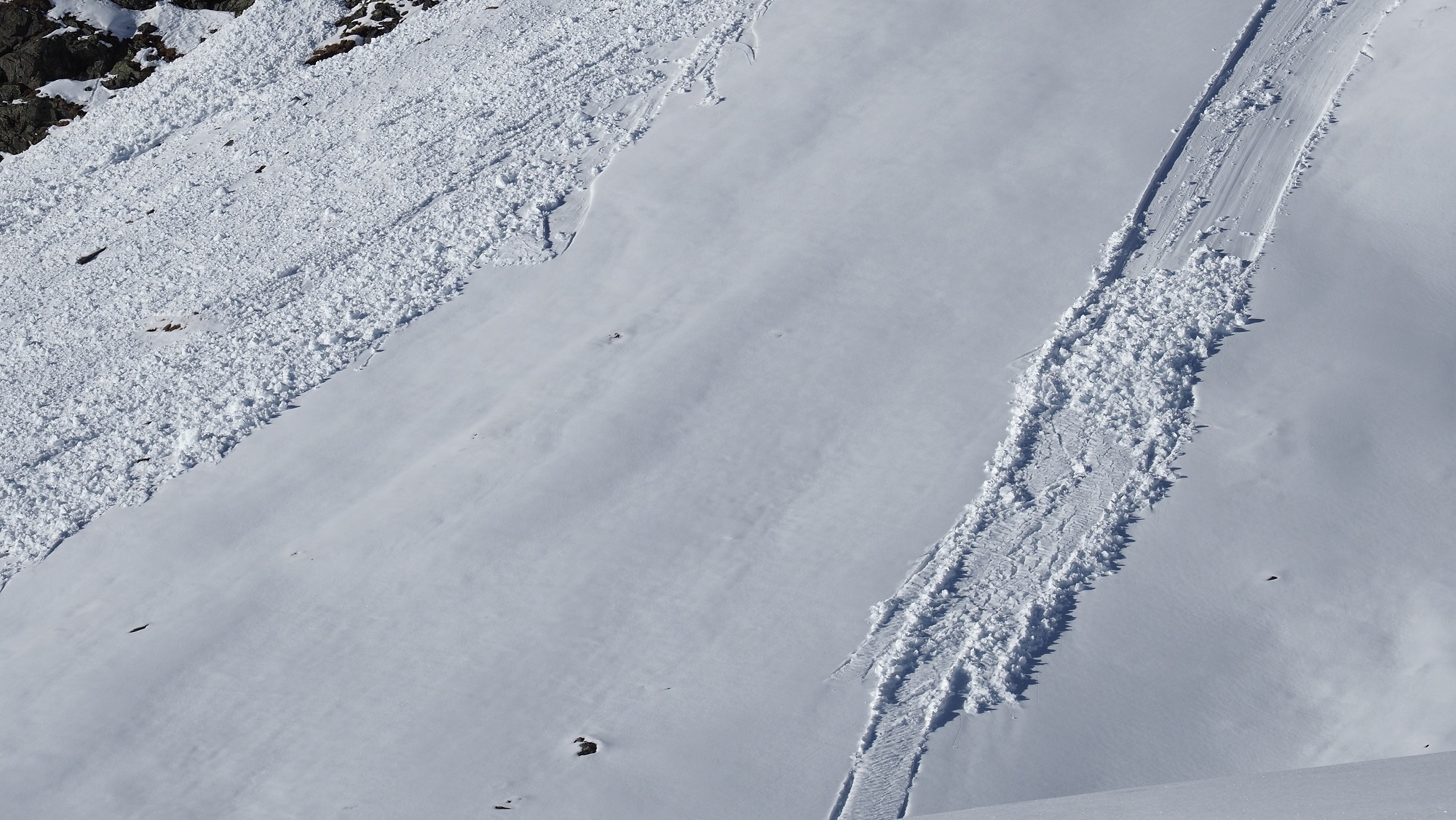
Vereinzelt können an steilen Grashängen noch kleine Gleitschneelawinen abrutschen. Hier am Widdersberg in den Kalkkögeln (© Barbara Fink, 11.12.2025).
On steep grass-covered slopes, small glide-snow avalanches can glide away in isolated cases. Above, Widdersberg in the Kalkkögeln (© Barbara Fink, 11.12.2025).

Generally speaking, other dangers are currently coming to the forefront: since there is such a small amount of snow on the ground, the dangers of rocks and hard ground are a threat to skiers and boarders in off-piste terrain. Also the rain crusts up to at least 2600m from Monday have created a “bone-breaker” – breakable crusts are a real threat. The best bet for skiers is to stick to sunny slopes wherever there is sufficient snow and where the melt-freeze crusts can often turn to firn snow, depending on altitude.

Weiterhin für die Jahreszeit unterdurchschnittliche Schneehöhen auf Tirols Bergen.
Persistently below-average snow depths in Tirol for this juncture of the season.

Outlook: stable high-pressure front weather, no change in the avalanche situation

The weak cold front that brought us a bit of gloomy weather north of the Main Alpine Ridge today, Thursday 11.12, will be over by tomorrow, Friday. Stable high-pressure weather conditions, mild temperatures, lots of sunshine, little wind form the expected scenario for the weekend. That means hardly any change in avalanche danger, it will continue to be low. Avalanche prone locations for dry-snow avalanches will become fewer, steep south-facing slopes are becoming bare of snow.

Temperaturprognose für Obergurgl (2019m): In den nächsten Tagen begleiten uns weiterhin recht milde Temperaturen. Die Frostgrenze liegt tagsüber stets in hohen Lagen (©Meteoblue).
Temperature forecast for Obergurgl (2019m): for the next few days, quite mild temperatures, the zero-degree level will lie at high altitudes. (©Meteoblue).
Die akkumulierte Neuschneesumme für die Tuxer Alpen: bis Ende nächster Woche kein Schnee in Sicht (© GeoSphere Austria).
Accumulated amounts of fresh snow in the Tux Alps: at least until the end of next week, no snowfall in sight (© GeoSphere Austria).

Review of last week

Artificial snow-slab on Leppleskofel

A brief interesting detour: a naturally triggered slab avalanche which unleashed last Saturday, 6 December, on Leppleskofel inside the ski area of St. Jakob in Defereggen.

The precise location: a part of the regular piste No. 11, a steep northwest-facing slope with a gradient of 30 – 35° at 2550m altitude. At the time of the avalanche, neither the lift on Leppleskofel nor the piste were open. There were no persons involved in the avalanche. The only damage caused by the snow masses was a single snow-cannon that was swept along.

What is interesting is the combination of slab plus weak layer which led to the avalanche’s release. The slab consisted primarily of artificial snow. During the hours and days prior to the triggering, this zone was intensively blanketed with artificial snow. However at ground level there was a weak fundament of large-sized faceted crystals constituting a weak layer which developed in early winter when the natural snow cover expansively metamorphosed during a phase of fine weather. The snow cannons stopped making snow about an hour before the avalanche, due to mild temperatures. Moreover, one person skied down the slope without triggering the slab.

Übersichtsbild der mittelgroßen Schneebrettlawine am Leppleskofel (© Roland Kendlbacher, 06.12.2025).
Overall view of the medium-sized slab avalanche on Leppleskofel (© Roland Kendlbacher, 06.12.2025).
Anrissbereich der Lawine. Die Anrissmächtigkeit betrug bis zu 1,5m (©Mark Kleinlercher, 06.12.2025).
Fracture zone of the avalanche. Depth of fracture: up to 1.5 metres (©Mark Kleinlercher, 06.12.2025).
Eine Schneekanone wurde von den Schneemassen mitgerissen und beschädigt. Der produzierte Kunstschnee war aufgrund der milden Temperaturen recht warm. Entsprechend war auch die Lawinenablagerung feucht-nass (©Mark Kleinlercher, 06.12.2025).
One snow cannon was swept along and damaged by the avalanche. The artificial snow was quite warm due to mild temperatures, making the snow deposited by the avalanche moist-to-wet (©Mark Kleinlercher, 06.12.2025).

Rain up to high altitudes led to frequent naturally triggered avalanches for a brief spell

The warm front which passed through the land from Sunday afternoon until Monday afternoon (7-8 December) brought 20-40mm of precipitation to northern and western regions of North Tirol, between 10 and 20mm south of the Inn and in the Hohe Tauern. The ascending snowfall level was striking. Monday morning it rained up to 2600m. In the moist and warm air, a thin melt-freeze crust formed on the snowpack surface up to over 3000m in some places.

As a result of the warmth and the water seepage into the snowpack, there were frequent naturally triggered wet loose-snow avalanches registered which particularly on shady slopes swept along the soft, metamorphosed snowpack all the way down to the ground, sometimes reaching medium size. Also near-surface slab avalanches were reported, frequently released on surface hoar. In addition, the gliding snow activity on steep grass-covered slopes increased for a short time.

Am meisten Niederschlag gab es westlich und nördlich des Inns sowie im Kaisergebirge (©GeoSphere Austria).
Most of the precipitation occurred west and north of the Inn, and in the Wilder Kaiser massif (©GeoSphere Austria).
Mit der Warmfront stiegen die Temperaturen deutlich an, auch teils starker Westwind begleitete das Niederschlagsereignis.
As a result of the warm front, temperatures surged. Strong-velocity westerly winds often accompanied the precipitation.
Anstieg der trocknen Schneefallgrenze in der Weißkugelgruppe.
Ascending dry-snowfall level in Weisskugel Massif.
Mit dem Regeneintrag lösten sich zahlreiche spontane Lockerschneelawinen, zum Teil auch oberflächennahe Schneebrettlawinen aus sehr steilem bis extrem steilen Gelände (©LWD Tirol, 09.12.2025).
As a result of rain seepage, numerous loose-snow avalanches triggered naturally, also near-surface slab avalanches on very-steep to extremely-steep slopes (©LWD Tirol, 09.12.2025).
Eine nasse Lockerschneelawine, welche sich im felsdurchsetzten Steilgelände löste, riss hier bis zum Boden durch und löste in der Folge noch ein kleines Schneebrett aus (©Tobias Holzknecht, 08.12.2025).
A wet loose-snow avalanche that unleashed in steep, rocky terrain, fractured down to ground level and subsequently triggered a small slab (©Tobias Holzknecht, 08.12.2025).
Zeichen markanten Regeneintrags in die Schneedecke in den Kitzbüheler Alpen (©Marvin Raaijmakers, 08.12.2025).
Signs of striking rain seepage into the snowpack in the Kitzbühel Alps (©Marvin Raaijmakers, 08.12.2025).
Lockerschneelawinen rissen in ihrer Sturzbahn oft die gesamte schwache Schneedecke mit und erreichten dadurch im Auslauf mitunter beachtliche Ausmaße. Peischelspitze, Lechtaler Alpen (©Adi Kerber, 08.12.2025).
Loose-snow avalanches often swept away the entire weak snowpack in their plummet path and thereby grew to impressive magnitude. Peischelspitze, Lechtal Alps (©Adi Kerber, 08.12.2025).
Auch die Aktivität von Gleitschneelawinen nahm mit dem Regen vorübergehend wieder deutlich zu. In der Zwischenzeit ist die Gleitaktivität wieder deutlich zurückgegangen. Stillupptal, Nördliche Zillertaler Alpen (©Thomas Eder, 08.12.2025).
Activity of glide-snow avalanches also temporarily surged as a result of the rain. In the interim, gliding snow activity has receded significantly. Stillupptal, northern Zillertal Alps (©Thomas Eder, 08.12.2025).