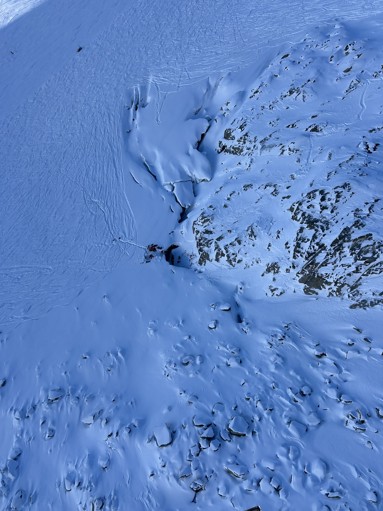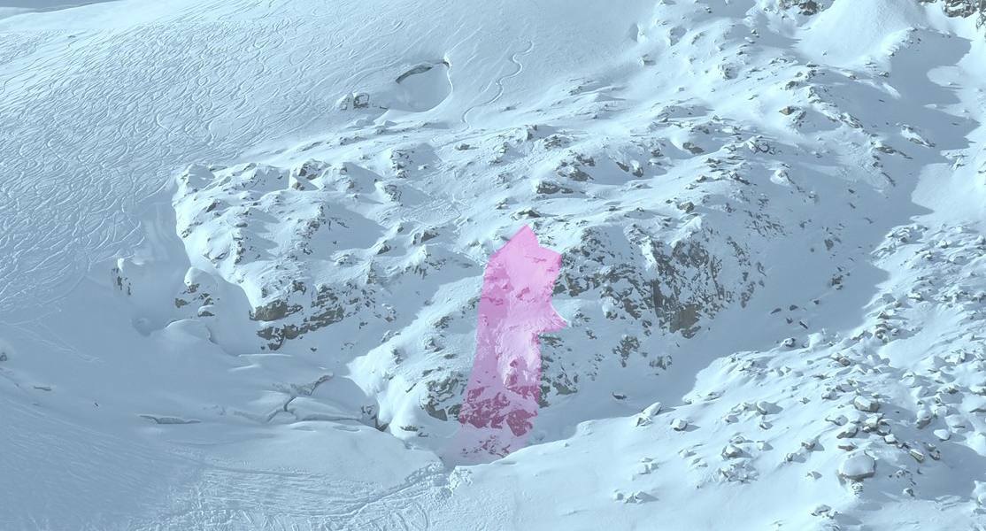
Lawinenunfall Östlicher Daunkogel vom 14.11.2026 (©LWD Tirol, 15.11.2026).

Avalanche incident Eastern Daunkogel – Mid-Stubai Alps, 14.11.2026

On 14.11.2026 below the 3330m-high Eastern Daunkogel in the Stubai Alps, a person was struck by a small slab, swept over rocky terrain and ultimately buried in a rimline chasm. The person died at the scene of the incident.

Cause of the incident was the freshly formed, trigger-sensitive drifted snow.

The unfolding incident

On 14.11.2026 towards 11.30 am, a person was in the unsecured skiing zone of the Stubai Glacier ski area below the Eastern Daunkogel. From the freshly snow-covered glacier terrain, the track led into increasingly steep and rocky terrain where at the foot of the slope there was a rimline chasm. The person triggered a small slab avalanche in extremely steep terrain and was partially buried in the rimline chasm at a depth of about 20 metres.

Persons in the ski area were witness to the avalanche and notified the rescue squad immediately. In an elaborate operation the person was found, but already dead, and retrieved from the rimline chasm.
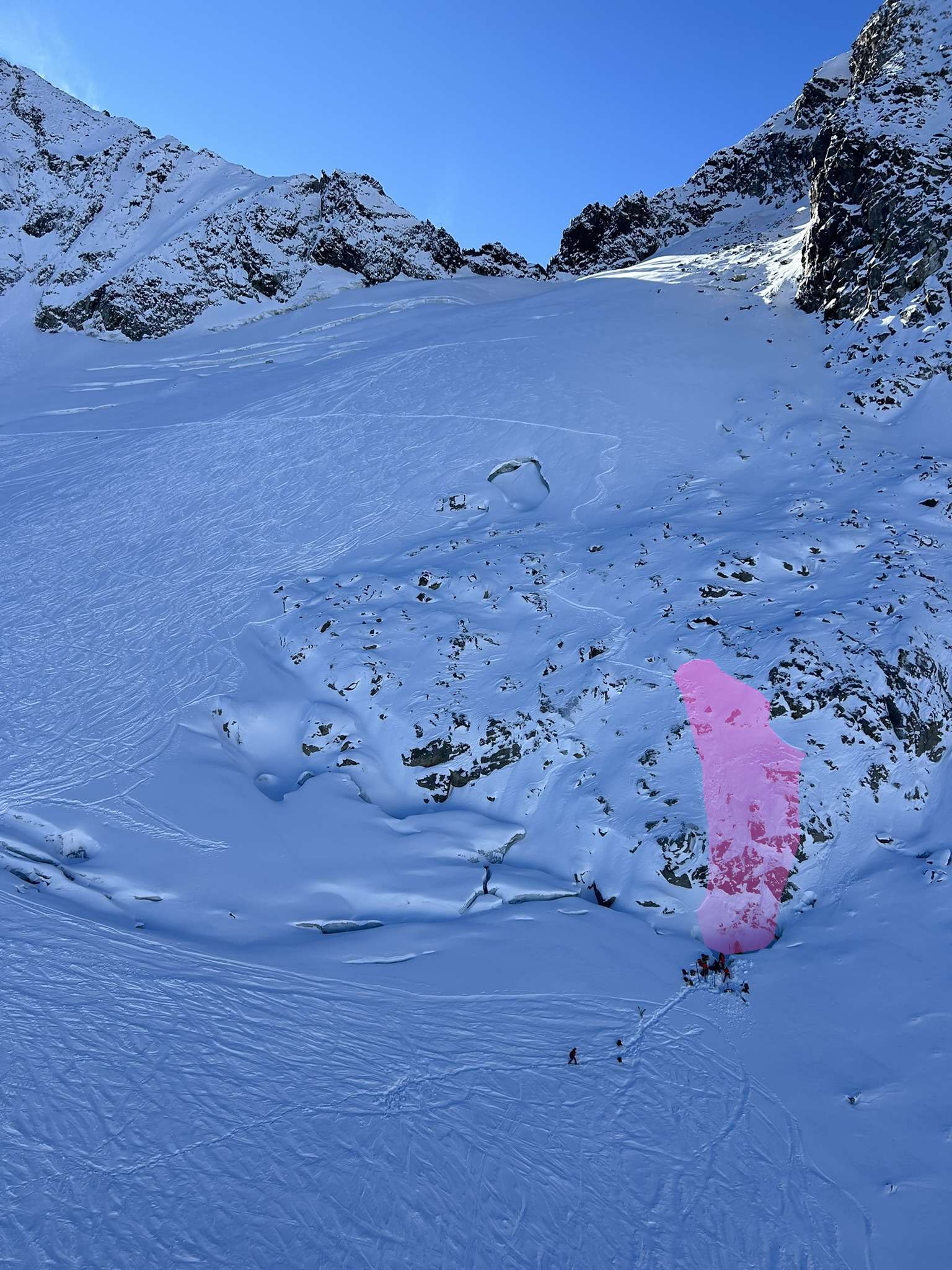
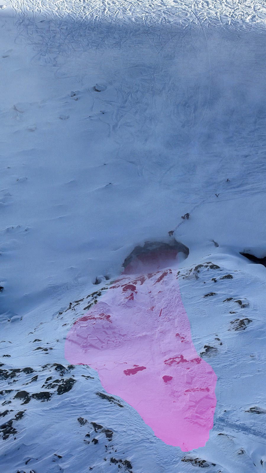
Lawine Östlicher Daunkogel: Eingezeichnet ist die kleine Lawine. Gut zu erkennen ist die Abfahrts- und Einfahrtsspur der Person. Am linken oberen Bild sieht man zudem eine Schneefahnen als Zeichen frischer Schneeverfrachtung. Das Foto wurde während der Rettungsaktion aufgenommen.  (©Alpinpolizei, 14.11.2026)
Avalanche Eastern Daunklogel: the small avalanche is marked. Easily visible is the descent and entry track of the person. Above left, in addition. the snow plume as indicator of fresh snow transport. The photo was taken during the rescue operation.(©Alpinpolizei, 14.11.2026)
Der Blick vom Hubschrauber zeigt eindrucksvoll das Absturzgelände samt der unmittelbar darunter befindlichen Randkluft. Rechts oben im Bild sieht man die Einfahrtsspur der Person (©Alpinpolizei, 14.11.2026).
View from helicopter shows impressively the terrain including the rimline chasm just below. Above right, the entry track of the person (©Alpinpolizei, 14.11.2026).
Ein weiteres Bild aus der Vogelperspektive während der Rettungsaktion (©Alpinpolizei, 14.11.2026)
Additional birds-eye view shot taking during the rescue operation (©Alpinpolizei, 14.11.2026).

The avalanche

The incident was, as mentioned above, a small slab avalanche with a length of about 50m, width of about 25m. The fracture depth varied between 10 and 30cm.
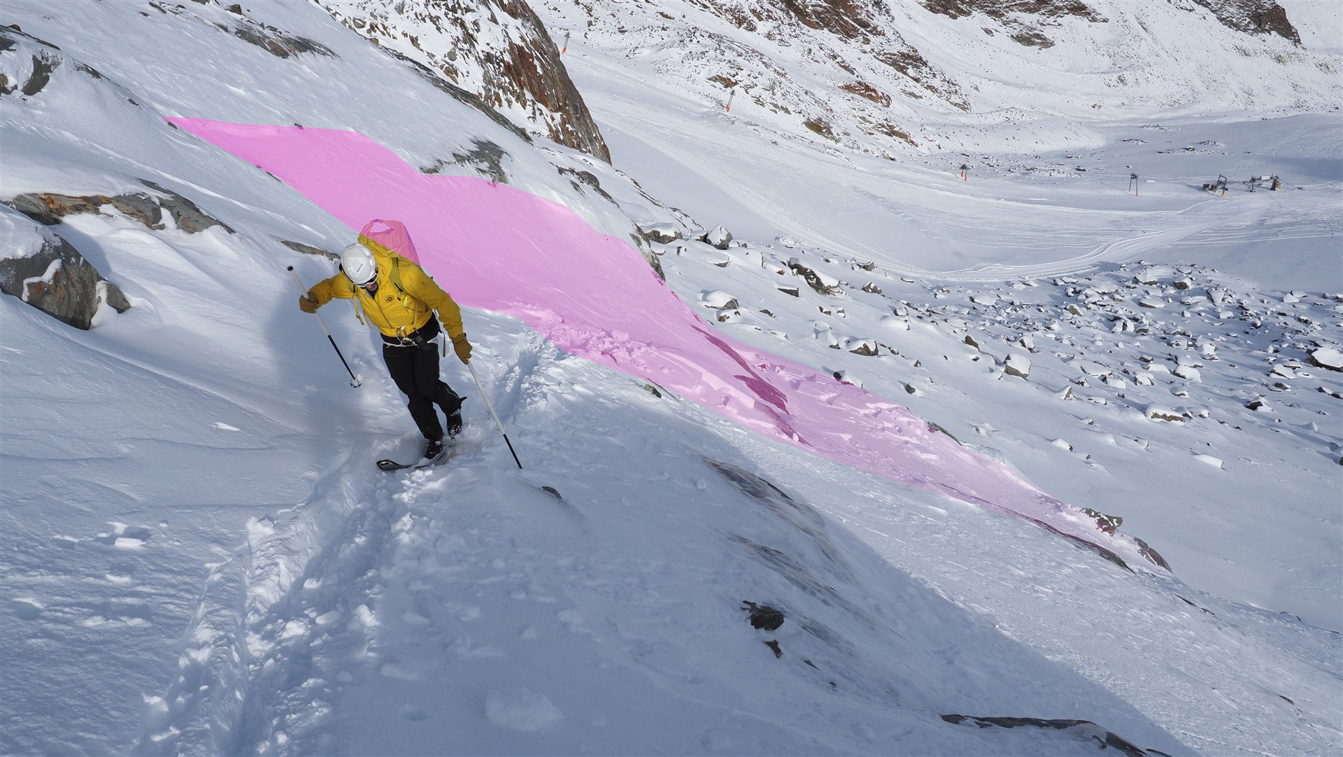
Die Lawine aus der Nähe betrachtet. Der oberste Anrissbereich war am Folgetag teilweise wieder zugeweht (©LWD Tirol, 15.11.2026).
By the day after the uppermost fracture zone was already drifted closed (©LWD Tirol, 15.11.2026).

The avalanche triggered at an altitude of approximately 3000m on an extremely steep, northeast-facing slope. The underground consisted partly of ice and of glacial rock plates.

The snowpack

Together with one of our observers from the Stubai Glacier and the Alpine Police, we conducted an analysis of the incident on the spot on 15.11.2026. A snow profile including stability tests was carried out in the immediate vicinity. It proved that the freshly generated snowdrift accumulations were often poorly bonded with the immediately previous snowfall and thus, prone to triggering. Let’s have a look at the snow profile in detail:
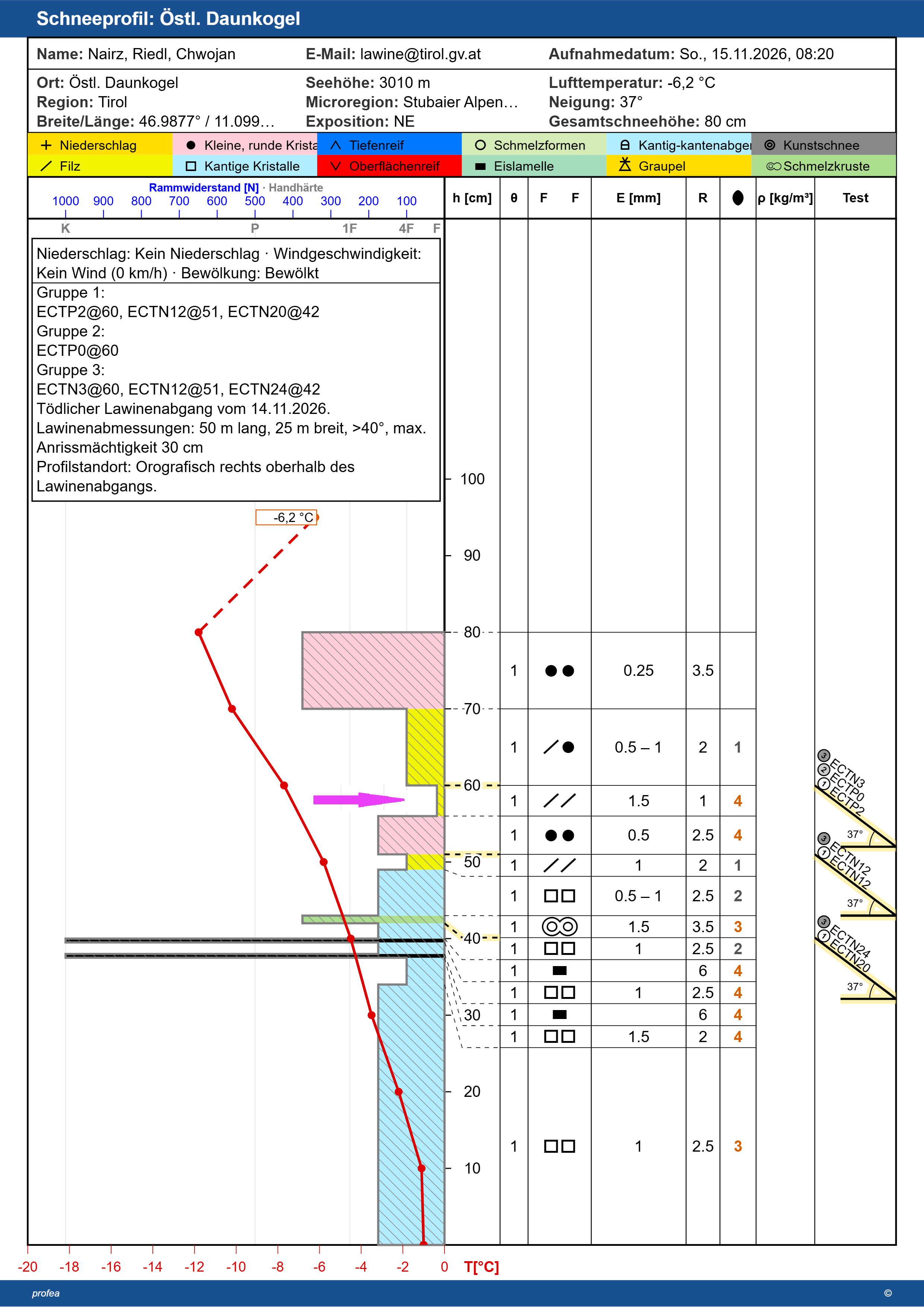
Schneeprofil vom Nahbereich des Lawinenabgangs: Der Pfeil weist auf die für den Lawinenabgang bedeutsame Schwachschicht hin. Es handelte sich dabei (am 15.11.) um immer noch sehr lockeren, filzigen Schnee, welcher ab dem 12.11.2026 gefallen ist. Das oberste, deutlich härtere Triebschneepaket löste sich bei mehreren durchgeführten Stabilitätstests (Gruppe 1 bis Gruppe 3) mitunter bereits bei sehr geringer Belastung. (Etwas versetzt von diesem Standort befand sich die Schwachschicht aus filzigen Kristallen unmittelbar unterhalb des Triebschneepakets.) Darunter erkennt man u.a. eine Abfolge von Krusten und bereits kantigen Kristallen. Die Verbindung dieser Schichten untereinander war, auch aufgrund von eingelagerten Schmelzkanälen, an diesem Standort recht gut.
Snow profile in the immediate vicinity of the avalanche incident: arrow indicates the relevant weak layer for the avalanche. This was a very loose, decomposed snow layer (on 15.11) which resulted from snowfall on 12.11.2026. The uppermost, much harder drifted snow mass triggered after several stability tests (group 1 to group 3) even from very little burdening. (Slightly removed from this location was a weak layer of decomposed snow crystals right below the snowdrift mass.) Below that, a series of crusts and faceted crystals is evident. The connection of these layers to one another was quite good in this spot, due to the embedded melt-canals.
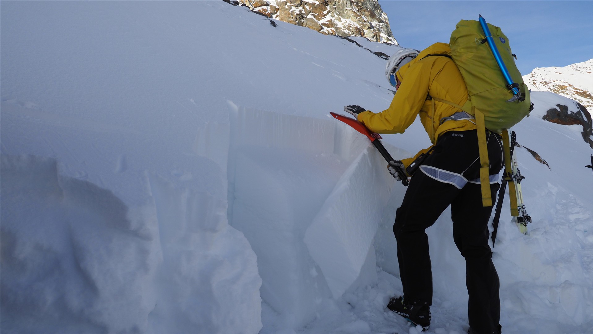
Das Foto entstand während eines Stabilitätstests. Man erkennt einen Schneeblock, der sich durch geringe Belastung gerade gelöst hatte (©LWD Tirol, 15.11.2026)
The photo was taken during the stability test. Visible: a snow block which just triggered through very little burdening (©LWD Tirol, 15.11.2026).

What is interesting in the analysis of the situation: the view of the previous, less heavy bouts of snowfall both in the near vicinity and at the weather stations.
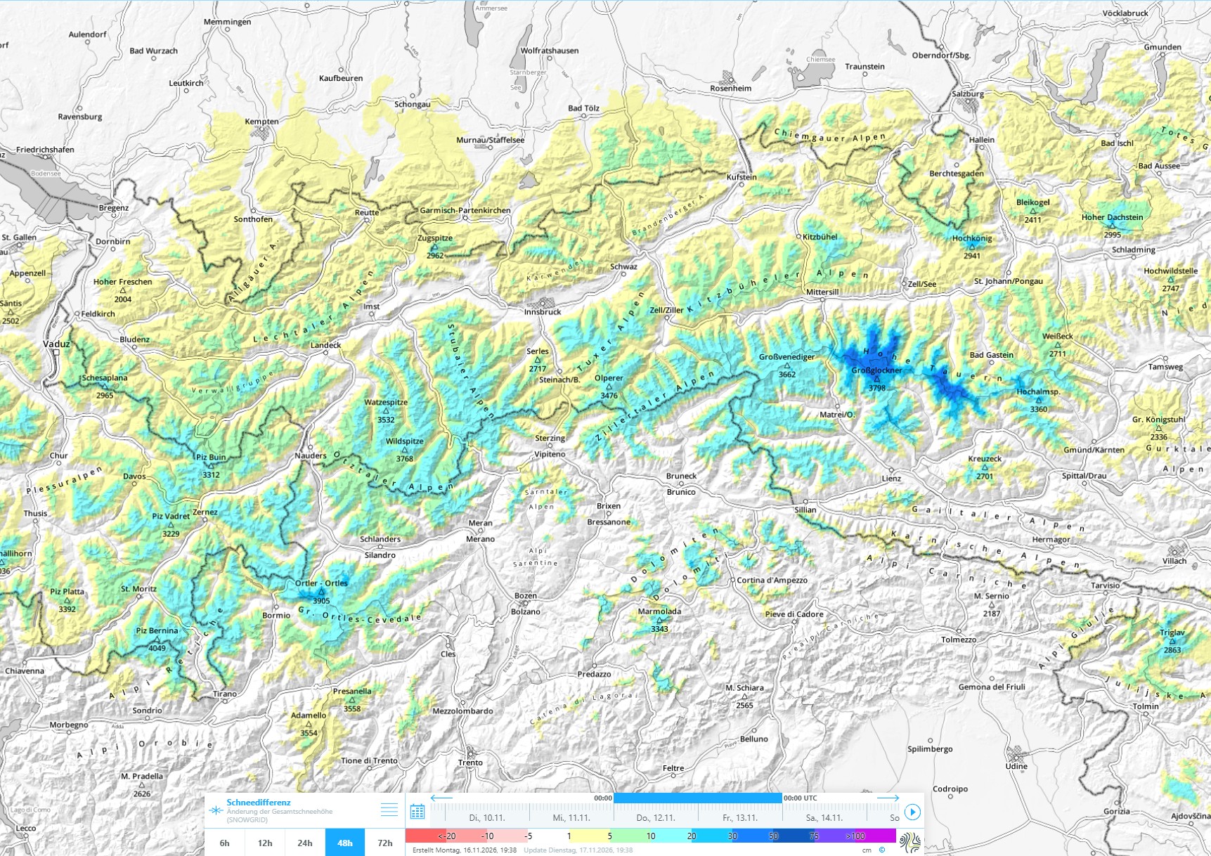
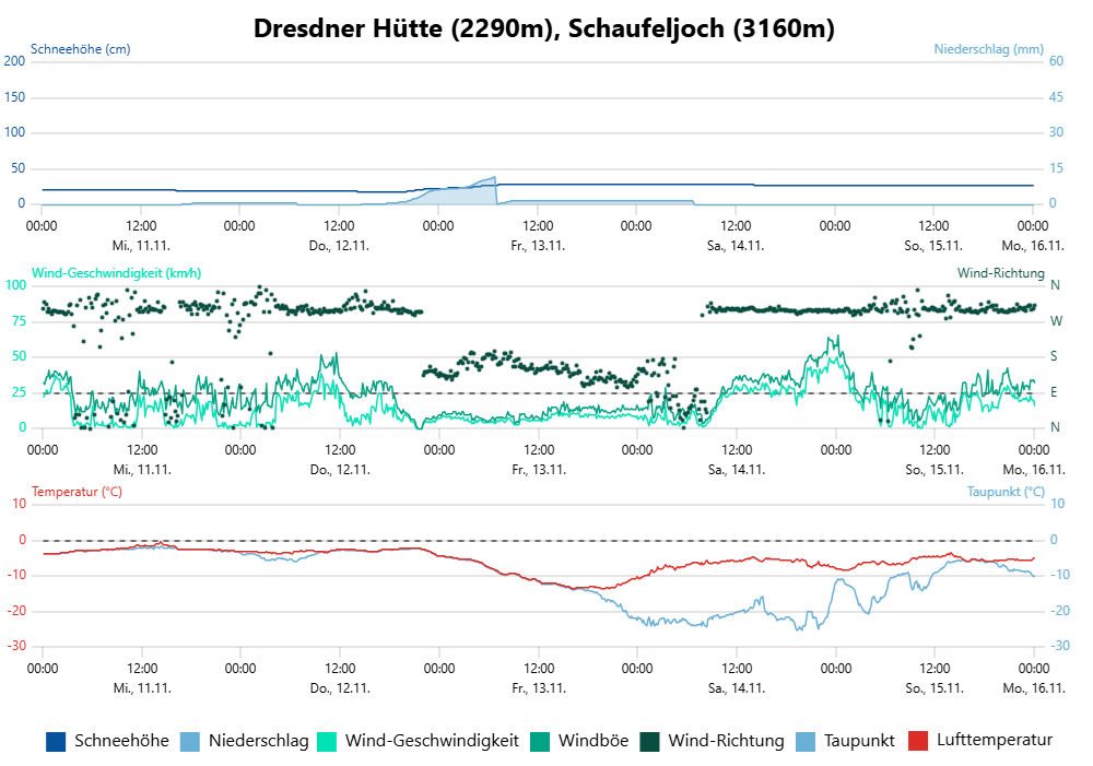
48h-Differenz der Schneehöhe zwischen Donnerstag, dem 12.11. und Freitag, dem 13.11.2026
48-hr difference in snow depths between Thursday, 12.11 and Friday, 13.11.2026.
Am Stubaier Gletscher befinden sich mehrere Wetterstationen. Hier ist jene von der Dresdner Hütte und vom Schaufeljoch abgebildet. Bedeutsam für den Lawinenabgang war der Niederschlag bzw. Neuschneezuwachs vom 12.11. auf den 13.11.2026. Man kann im höher gelegenen Unfallgebiet von einem Neuschneezuwachs von etwa 20cm ausgehen. Interessant ist in diesem Zusammenhang v.a., dass der Neuschnee anfangs bei sehr wenig Wind gefallen ist. Dieser hat erst im Laufe des 14.11. zugenommen und erst dann die frischen Triebschneepakete gebildet.
On the Stubai Glacier there are several weather stations. Above, data from the Dresden Hütte and Schaufeljoch is displayed. Of significance for the avalanche incident was the precipitation, i.e. the fresh fallen snow on 12.11 – 13.11.2026. From the somewhat higher-altitude zone of the incident region, we can assume approximately 20cm of fresh snow. Interesting in this connection is the fact that the fresh snow initially fell accompanied by very little wind. Winds intensified only during the course of the day on 14.11, which then generated fresh snowdrifts.

Slab and weak layer

As we know, a slab avalanche requires a bonded, somewhat hardened snow mass, together with a weak layer below it. In this case, it is quite clear that the fresh snow which initially fell with no wind became the weak layer. Starting on Saturday the winds increased, generating the requisite slab in the form of fresh snowdrifts. On the day of the incident, the weak layer, initially formed of fresh snow, had transformed to decomposed snow crystals. This process continues in the course of snow transformation (fresh snow – decomposed crystals – rounded crystals). The weak layer is thus becoming denser with each passing day, making it less and less prone to triggering. Loosely-packed fresh snow (blanketed with fresher snowfall) is therefore known as a “short-lived weak layer.”

Conclusion

It was a chain of highly varied conditions which led to the fatal avalanche incident.

Numerous avalanche incidents, also in past years, have repeatedly shown how important it is to be aware of the consequences even of small-sized avalanches. In this particular case, it was a terrain with a specific trap: the rimline chasm.

As is already well known, the glaciers are receding massively. This can have enormous effects on the terrain. Instead of a not-very-steep glacier surface, a steep, rocky terrain was exposed in this case.
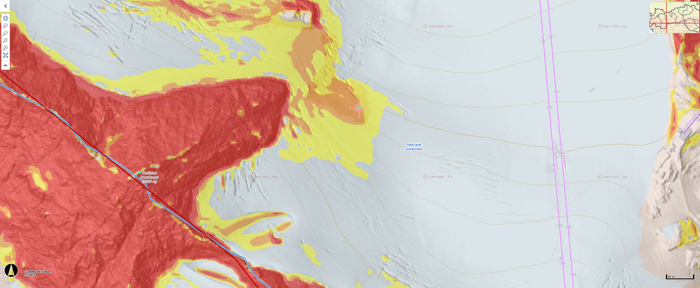
Ausschnitt aus einer Geländeneigungskarte: Im Bild links sieht man den Östlichen Daunkogel mit seiner nach Nordosten ausgerichteten Felsnase. Schräg rechts darunter (mit einer Markierung versehen) befindet sich der orographisch rechte Anrissbereich der Lawine. Nicht zu erkennen ist das inzwischen ausgeaperte, felsdurchsetzte (und somit deutlich steilere) Gelände (©tiris)
Excerpt of a terrain steepness map: left, the Eastern Daunkogel is visible with its north-facing rocky nose. To the slanted left beneath that (marked) is the orographically right fracture zone of the avalanche. Not visible is the now bare-of-snow rocky (and thus, much steeper) terrain (©tiris).