Avalanche incident on the Mute, Kühtai-Geigenkamm, 08.04.2026

Below the Mute in freeriding terrain of the Kühtai ski area in the northern Stubai Alps, two snowboarders were swept along by a wet slab avalanche on Wednesday afternoon, 08.04.2026. One person died in this avalanche incident.

The slab avalanche triggered in the ground-level weak layer from early winter that had been weakened as a result of moisture seepage. A situation which will remain of significance to avalanche danger over the coming days.

Unfolding of the event

On Wednesday afternoon, 08 April, three snowboarder friends climbed from the upper station of the HoheMutBahn in the Kühtai ski area to the nearby summit of the Mute (2398m) above the reservoir dam of the Finstertal Reservoir in order to return over the outlying freeriding terrain back to the ski area.

At about 3:30 pm the three persons boarded into the northeast-facing, often extremely steep (>40°) slope orographically left of the reservoir dam. At an altitude of about 2270m a slab triggered and swept along two of the group, while the third person was able to escape the plummeting snow masses through a downhill shot.

One of the persons caught in the avalanche was partially buried up to shoulder height in snow masses on an access road traversing the area of the plummet path, but suffered no injuries. The second person, on the other hand, was swept into the gully at the foot of the dam and completely buried. An alarm to the search-and-rescue squads unleashed a large-scale search. Since the snowboarder group had no safety equipment with them, it took some time for the buried person to be located. Shortly after 6:00 pm the person was localized beneath the snow masses by an avalanche dog. The rescue teams unburied the person from about one metre of snow. The person had already perished.
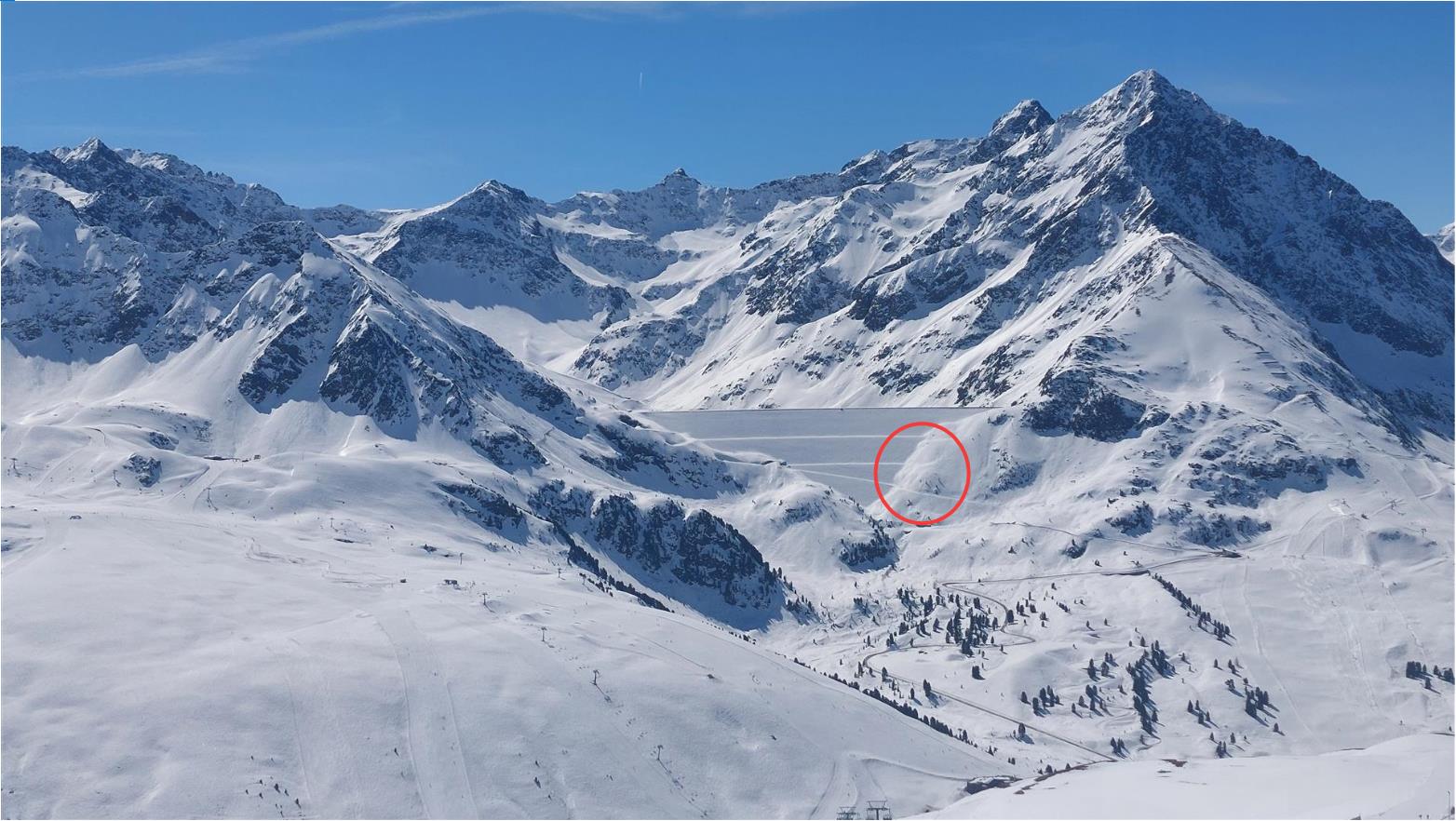
Der Bereich des Unfallgeschehens liegt orographisch links des Staudamms des Finstertaler Speichers. Das Bild wurde nur wenige Stunden vor dem Lawinenabgang aufgenommen (©LWD Tirol, 08.04.2026).
The area of the incident lies orographically left of the reservoir dam of Finstertal Reservoir. This photo was taken only a few hours prior to the avalanche release. (©LWD Tirol, 08.04.2026).
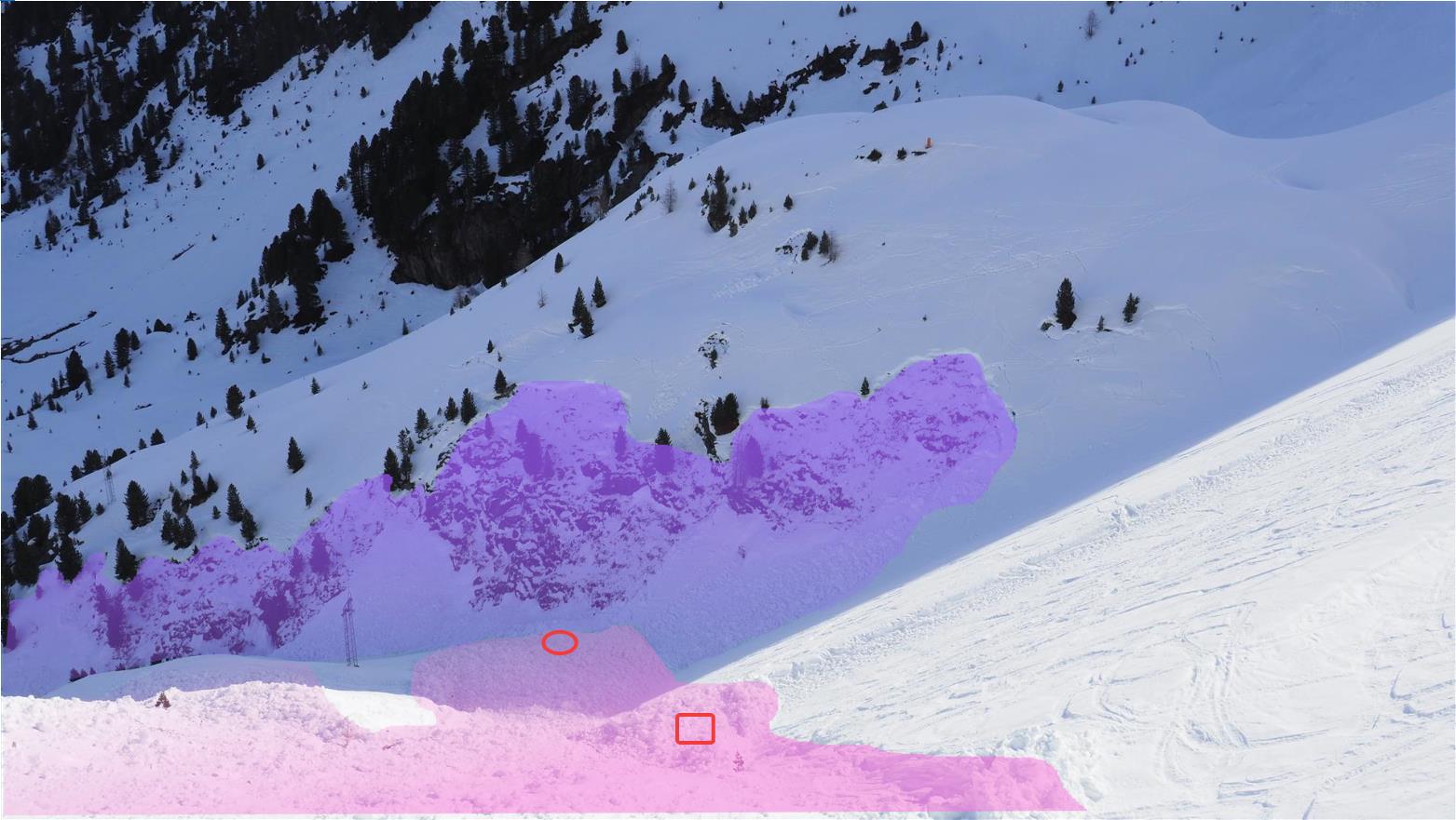
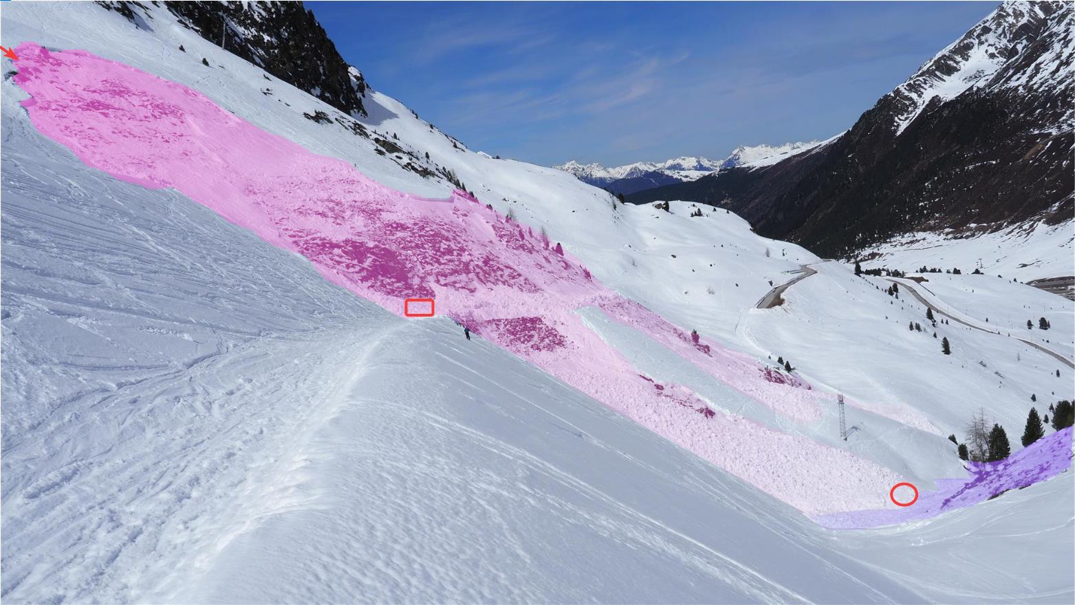
Überblicksbild der Unfalllawine (Magenta): Der rote Pfeil links oben markiert die Einfahrtsspuren der mitgerissenen Personen, das rote Rechteck den Ort, wo eine Person teilverschüttet wurde. Der rite Kreis zeigt den Verschüttungsbereich der verstorbenen Person. Am rechten Bildrand ist die Sekundärlawine in Violett markiert  (©LWD Tirol, 09.04.2026).
Overview of the fatal avalanche (magenta): red arrows at upper left mark the entry tracks of the persons who were swept along; red rectangle marks the spot where one of the persons was partially buried; red circle shows the spot where the person who died was buried. At right edge: a secondary avalanche marked in violet (©LWD Tirol, 09.04.2026).

The avalanche

The avalanche was a medium-sized, wet slab avalanche (Magnitude 2) which triggered on a northeast-facing slope at approximately 2270m. The steepness gradient of the slope was over 40 degrees in some places. The breadth of the avalanche was about 70m, the maximum runout zone about 250m. The depth of the fracture was an average 50cm.

Approximately at midway in the plummet path, a not-public and not-plowed access road to the dam crosses the avalanche slope. It was precisely on this access road that one of the two persons swept along by the avalanche was partially buried in snow. In the runout zone, the snow masses were channeled into terrain resembling a bowl. Through the powerful effect of the avalanche responsible for this incident, a secondary avalanche was also triggered on an equally steep (>40°) northwest-facing slope across the mountain.
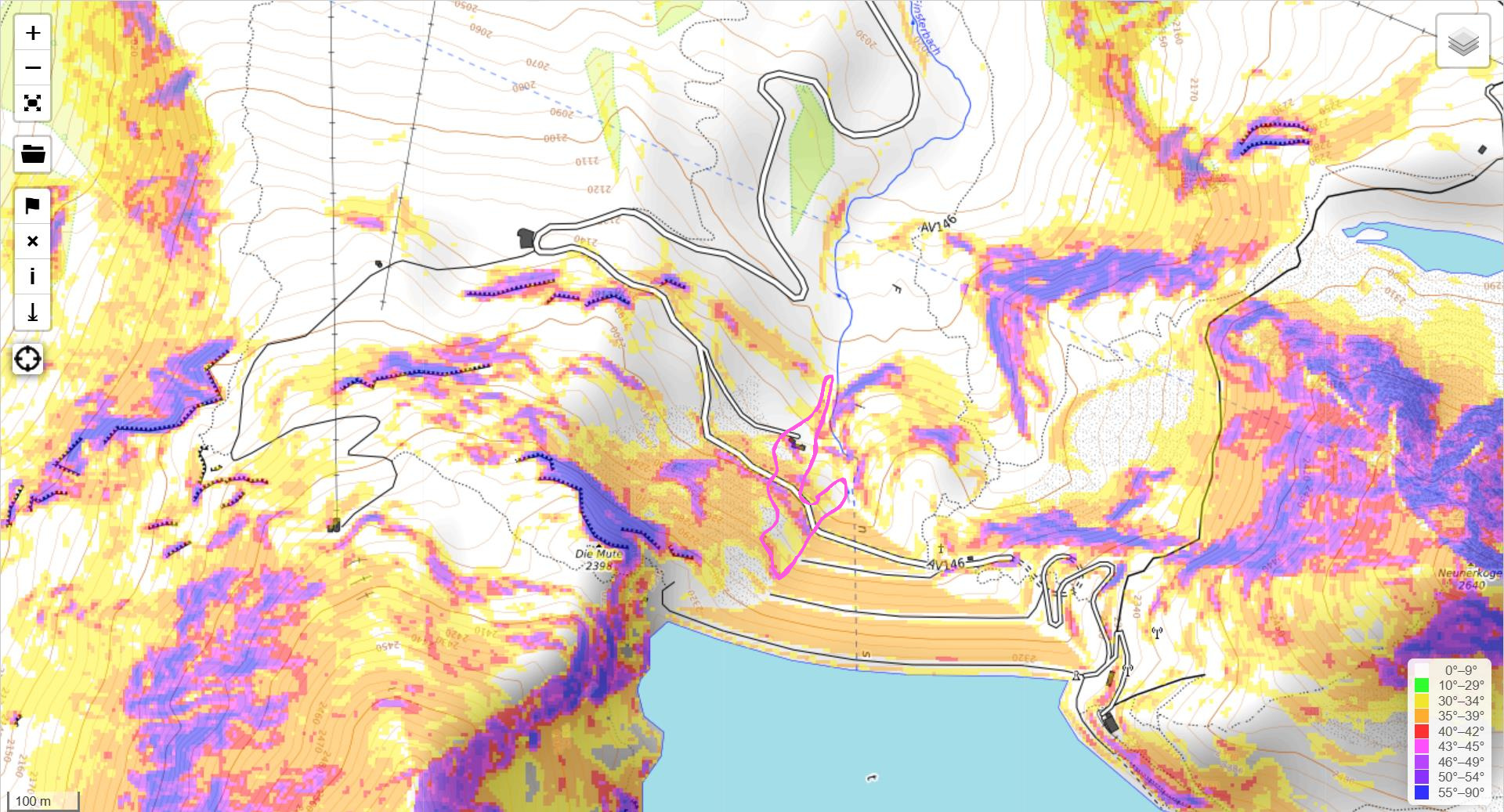
Die Unfalllawine im Bereich des Staudamms. Der Unfallhang ist stellenweise über 40 Grad steil (©openslopemap.org).
The avalanche near the reservoir dam is marked. The incident slope is often more than 40 degrees steep (©openslopemap.org).
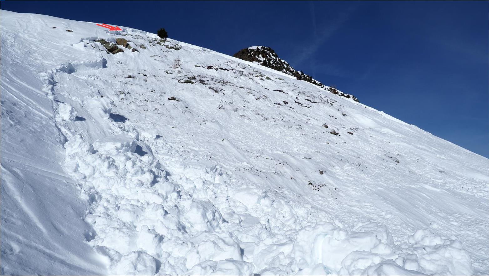
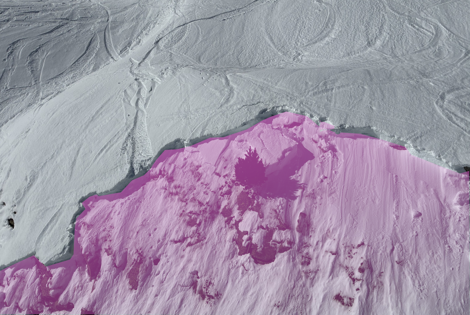
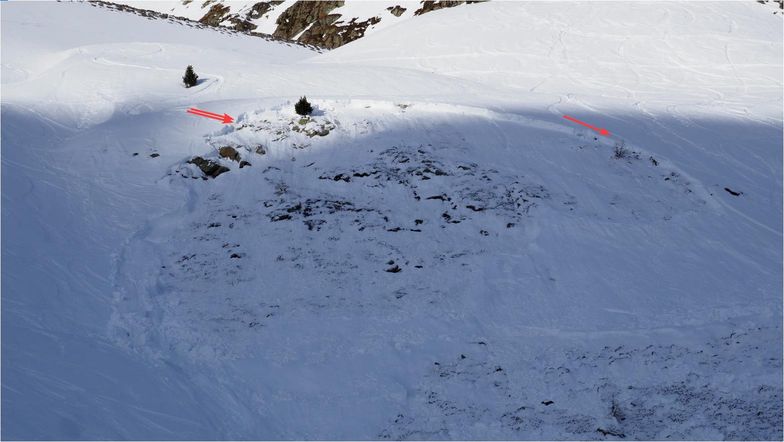
Der obere Anrissbereich der Schneebrettlawine. Links im Bild sind mit zwei Pfeilen markiert die Einfahrtsspuren der beiden mitgerissenen Personen, rechts im Bild die Spur jener Person, die von der Lawine nicht erfasst wurde. (©LWD Tirol, 09.04.2026)
The upper fracture zone of the slab avalanche. Left (marked by two red arrows): the entry tracks of the two persons who were swept along. Right: the track of the person who was not caught in the avalanche (©LWD Tirol, 09.04.2026).
Beim Lawinenhang handelte es sich teilweise um extrem steiles Gelände. Oben eingezeichnet wiederum der Einfahrtsbereich der zwei Snowboarder. (©LWD Tirol, 09.04.2027)
The avalanche slope was frequently extremely steep terrain. Marked at top of photo: the entry zone of the two boarders. (©LWD Tirol, 09.04.2027)
Blick vom Nahbereich der Einfahrtsspuren Richtung Verschüttungsstellen. (rotes Rechteck: teilverschüttete Person / rote Ellipse: verstorbene Person). In violett eingezeichnet ist die Sekundärlawine. (©LWD Tirol, 09.04.2026)
View from vicinity of entry tracks in the direction of the places the persons were buried in snow. Red rectangle: partially buried person. Red ellipse: deceased person. Shaded in violet: the secondary avalanche (©LWD Tirol, 09.04.2026).
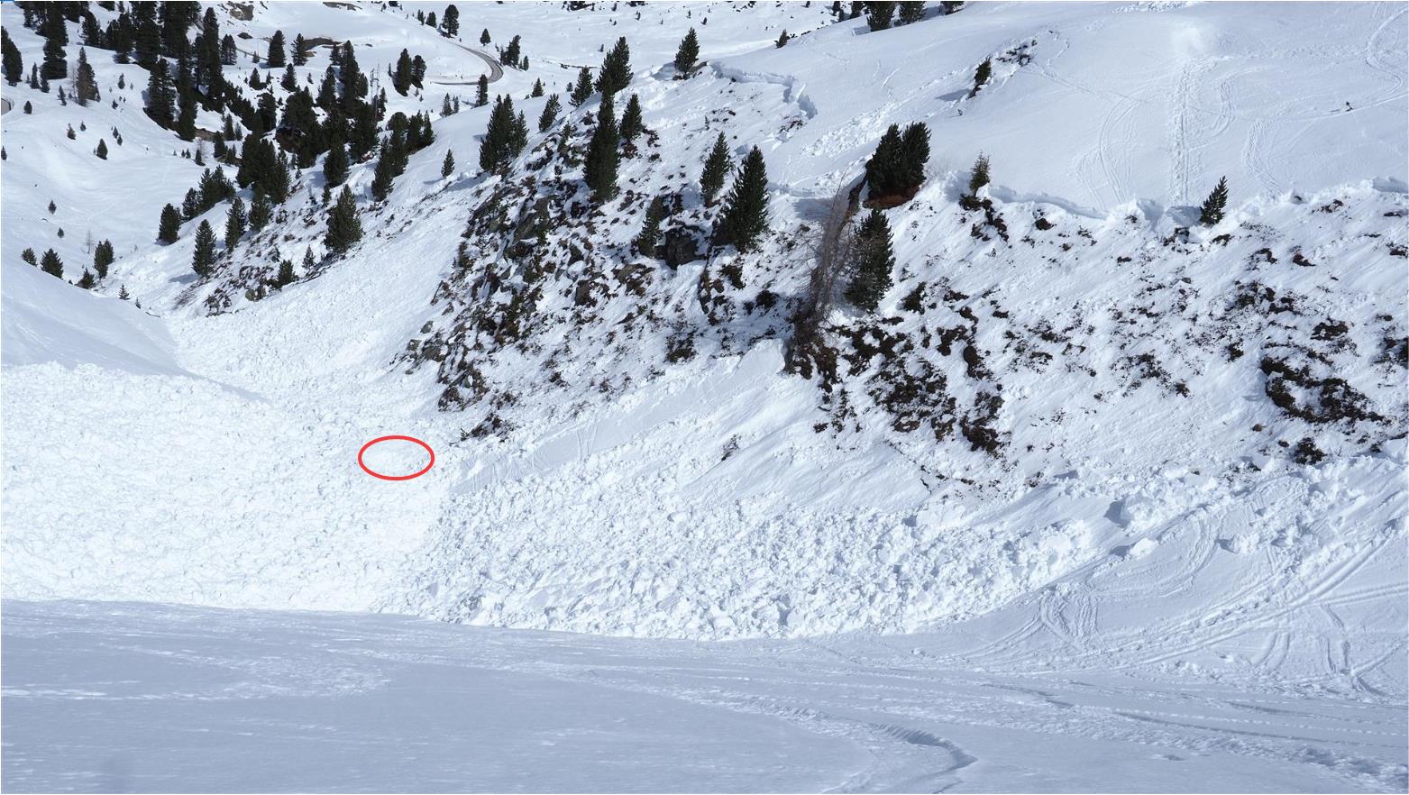
Die Verschüttungsstelle (rote Ellipse). Aufgrund des Ablagerungsbildes (Primärlawine lagert über Sekundärlawine) schließen wir, dass die Lawine im unteren Teil des Hanges ausgelöst wurde. Unmittelbar darauf löste sich die Sekundärlawine. In weiterer Folge überspülte der obere Teil der Primärlawine die Ablagerung der Sekundärlawine, was folglich zu einer erhöhten Verschüttungstiefe des Lawinenopfers führte (©LWD Tirol, 08.04.2026).
The place of snow burial (red ellipse). Based on the photo of the avalanche deposit (primary avalanche is deposited on top of secondary avalanche), we conclude that the avalanche was triggered in the lower sector of the slope. Immediately thereafter, the secondary avalanche triggered. Subsequently, the upper part of the primary avalanche flowed over the deposit of the secondary avalanche which led to greater snow masses burying the victim (©LWD Tirol, 08.04.2026).

The snowpack

On the following day, 09.04, we carried out an analysis of the incident including a thorough examination of the snowpack. In the course of this analysis it became evident that the cause of the avalanche once again was the ground-level weak layer generated in early winter.

During the days prior to the incident, as well as on the day of the incident, warm temperatures and solar radiation caused moisture seepage into the snowpack. The weak layer at ground level was weakened by this seepage. In addition, the snowpack surface in the afternoon was already weakened, making it more easily possible for zones deeper down inside the snowpack to be triggered.

Auffallend ist das stark verspurte Gelände im Unfallhang. Gerade bei langanhaltenden Schwachschichten tief in der Schneedecke dürfen Spuren nicht als Zeichen der Sicherheit oder geringeren Gefährdung bewertet werden (©Alpinpolizei, 09.04.2026).
The heavily-tracked terrain on the avalanche slope is conspicuous. In particular in the case of long-enduring weak layers deep down inside the snowpack, tracks are not a sign that the slope is safe or that there is less danger of triggering (©Alpinpolizei, 09.04.2026).
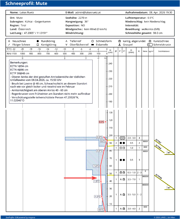
Snow profile taken on the day of the avalanche incident at the upper point of the avalanche fracture by our observer Lukas Ruetz. The arrow marks the weak layer relevant to the avalanche incident. At this location the snowpack was not yet 0° isotherm, however, further down the slope, it was. Other profiles which were taken in the vicinity on this day and the following day can be seen – as always – on LAWIS.
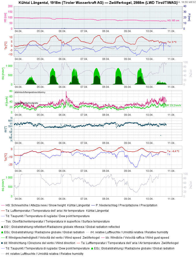
Daten der im Nahbereich gelegenen Wetterstation am Eingang des Längentals in Kühtai. Die Schneeoberflächentemperatur lag vergangene Woche häufig im Nahbereich von 0°C. Vom 07.03. auf den 08.04. kühlte die Schneedecke während der Nachtstunden nur leicht aus, Zeitig am Vormittag wurde die Schneeoberfläche wieder feucht.
Data recorded by the weather station at the entrance to Längental in Kühtai in the vicinity of the avalanche. Snowpack surface temperature last week was often near to 0°C. On 7-8 March the snowpack cooled only slightly during the nocturnal hours, so the snowpack surface swiftly moistened again during the morning.