Category: Current situation
-
Numerous trigger-sensitive snowdrifts above timberline. We recommend enormous restraint in steep terrain.
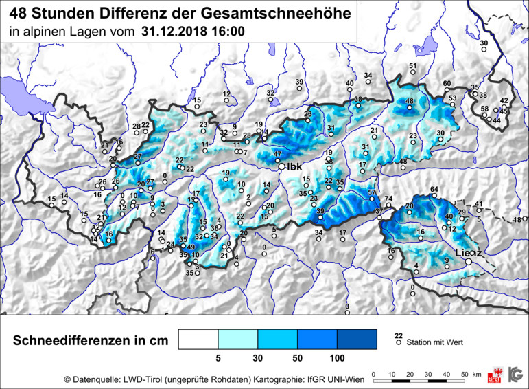
Caution: Similar to 25.12.2018, the first day of the new year 01.01.2019 as “first fine-weather day” following a period of stormy snowfall is also an accident-prone day. Snowfall and storm winds: During the last two days in North Tirol and in northern East Tirol, there has been snowfall accompanied by formidable winds. The focal point…
-
Caution: beautiful weather after stormy period is particularly accident prone
The forecasts of the ZAMG weather service were correct. There has been much rainfall and snowfall in far reaching regions of Tirol. In addition, storm-strength NW winds were blowing in many regions at high altitude. All in all over the last few days in the western regions of the land, there was at least 50…
-
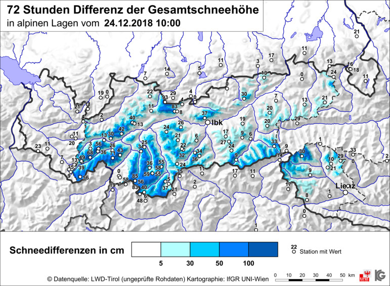
Increasing number of weak spots with rain and snow on the weekend – warm-thaw Christmas weather
Weather review This last week has again been highly variable: sunshine, clouds, some precipitation. The extremely cold phase came to an end on 16.12, subsequent temperatures rose continually. Three phases of wind were observed: on 13.12 a strong southerly wind prevailed, on 16.12 winds shifted to westerly, on 19.12 winds again were southerly from region…
-
Trigger sensitive snowpack in places
Recent avalanches showcase a trigger-sensitive snowpack, at least in certain regions. Two dangers threaten currently: – Fresh snowdrifts – Trigger-sensitive old snowpack regionally Freshly generated snowdrifts are always easily triggered when unbonded fresh snow is transported at low temperatures. Both coordinates are currently fulfilled. It is very cold. There were strong-velocity winds in the…
-
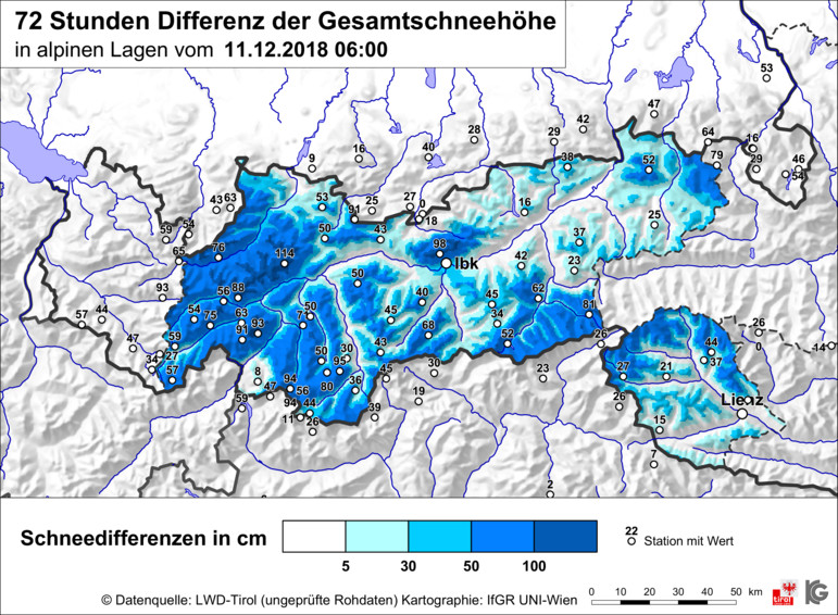
Restraint imperative after onset of winter
Winter has arrived in Tirol. Since Saturday, 8.12.2018, more than 100 cm of fresh snow has been registered at high altitudes. Enormous amounts of fresh snow in far-reaching parts of Tirol Review On Friday 7.12 in far-reaching parts of Tirol, an intermediate high generated very pleasant weather conditions and mild temperatures. The zero-degree level during…
-
Isolated danger spots: small, easily recognized snowdrifts
Isolated danger spots: small, easily recognized snowdrifts For backcountry skiing and freeriding tours, in most parts of the countryside there is still not enough snow. Only along the Main Alpine Ridge are we receiving reports of high-altitude, mostly shady slopes where conditions are acceptable. Wintery conditions on shady slopes at high altitude as above, south of…
-
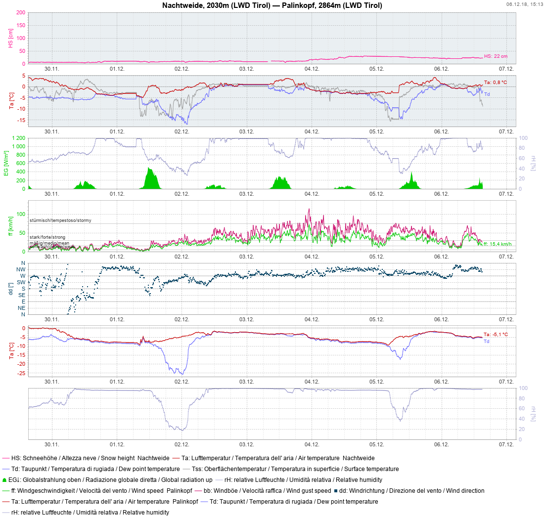
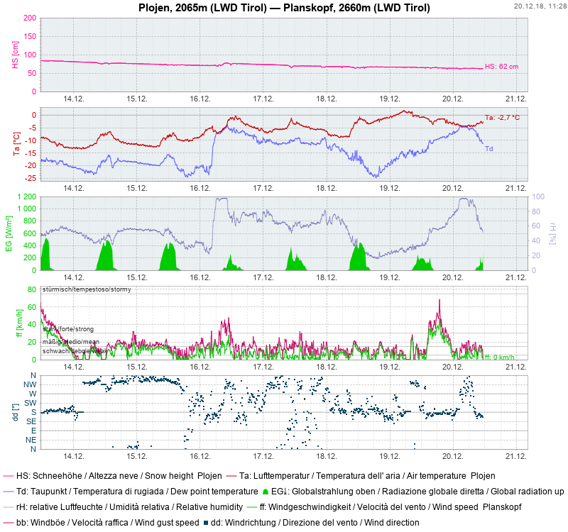
After a roller-coaster week, winter draws nearer
After a roller-coaster week, winter draws nearer Highly variable conditions have prevailed during the last week. Repeated bouts of rainfall or snowfall occurred The snowfall level lay between 2000 and 2800 m. At high altitude, the winds intensified measurably, blowing from westerly directions. Example of variable weather conditions at the Nachtweide-Palinkopf station (Silvretta Group) Alternating…
-
A first analysis of the snowpack
The winter to date At this juncture of the season, winter has been launched only at high/high-alpine altitudes in the southern regions of the land. It was generated by intensive precipitation at the end of October. As we know, this precipitation was accompanied by thunderstorms which led to mudslides, flooding and far-reaching windstorms in southern regions. A…