Category: Current situation
-
Instable weather determining avalanche danger: beware trigger-sensitive snowdrifts!
Outlook Stormy southerly foehn winds which have been raging over North Tirol since yesterday, Wednesday 06.03, were the harbinger of a cold front which will move across all of Tirol tonight and bring some precipitation. On the way in the field, while the cold front is pulled through in the area of the Aifner (photo:…
-
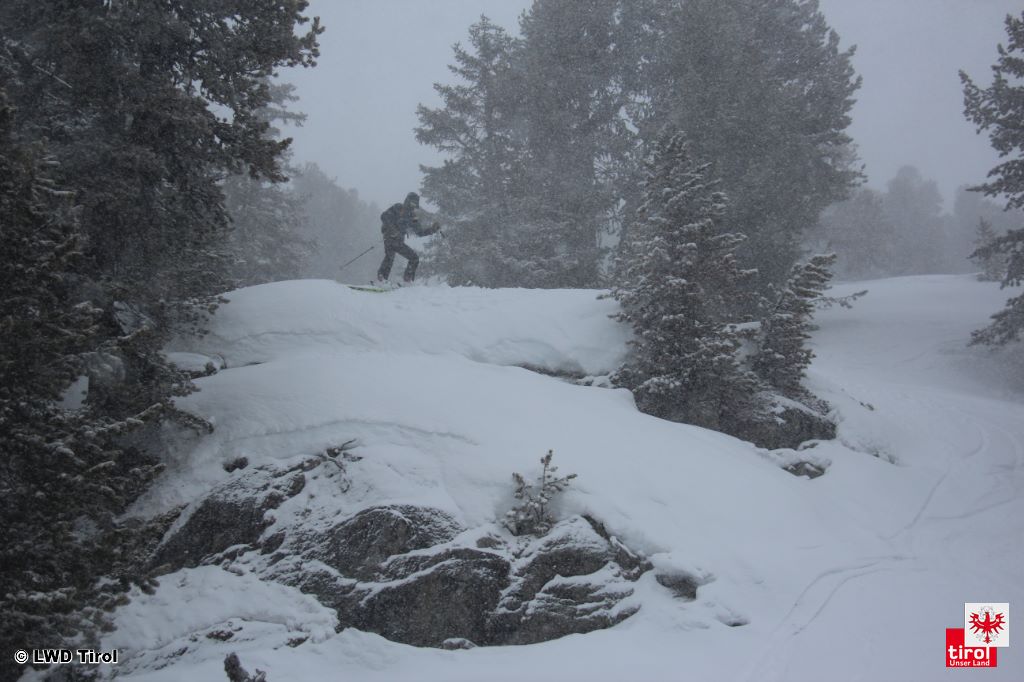
Some fresh snow, wind, temporarily receding temperatures. Caution: gliding snow!
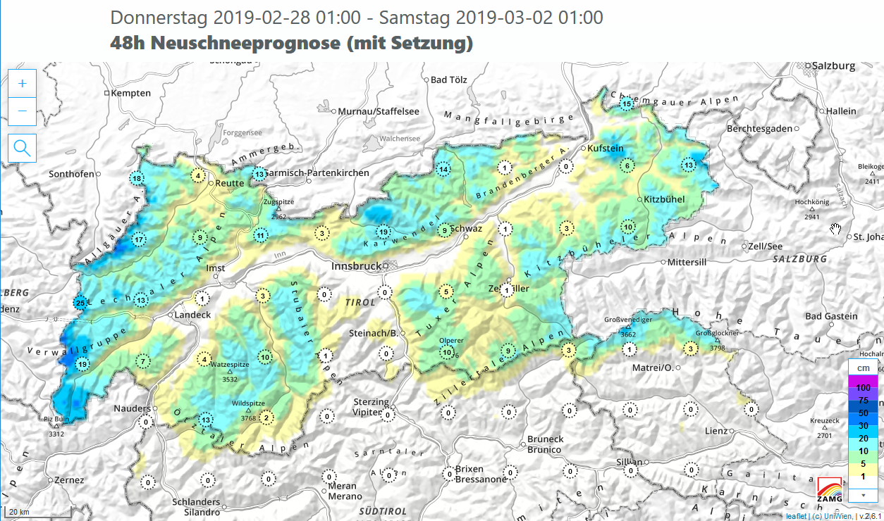
Outlook On Thursday night a cold front will reach us, bringing strong NW winds to the northern flank of the Alps and temporarily terminating the springlike conditions. Already on Thursday, 28.02, the cold front has announced its approach with intensifying NW winds and slightly decreasing temperatures at intermediate and high altitudes. About 20-30 cm of…
-
Fresh snow + strong winds spike avalanche danger
Outlook Wedged between a high over southern Scandinavia and a low over Russia, Tirol will be pressed into a powerful northeasterly airstream tomorrow, Friday 22.02. Strong to storm-strength winds in the mountains will be the result, along with some precipitation, particularly in the eastern regions. The fresh snow and, in some places, loosely-packed old…
-
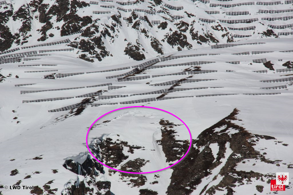
Caution: glide-snow avalanches can grow to large size. Daytime avalanche danger cycle!
As expected, we are currently observing increasingly frequent glide-snow avalanches on steep, grass-covered slopes. This is the result of higher temperatures, more intensive solar radiation and the increasing wetness of the snowpack. The melt water penetrates to the base of the snowpack on grass-covered slopes and decreases its friction with the ground. This applies increasingly…
-
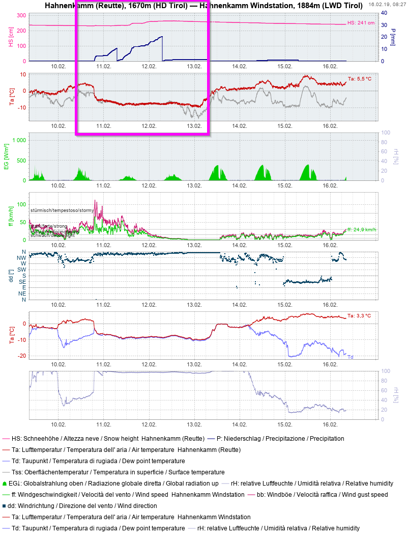
Possible weak layer at narrow altitudes on shady slopes
We are currently facing Danger Pattern 4 (cold on warm) from region to region in a very narrow altitude band. Background: on Sunday 10.02 there was rainfall/wet snowfall in Tirol up to about 1600-2200 m. Subsequently, temperatures plummeted. The rain turned to snowfall. Thereafter it was persistently cold.Tthe weather is currently subject to great temperature…
-
Current situation / More snow=more avalanches?
This blog is sub-divided into two parts: Short and sweet: a description of the current situation. A detour: “More snow = more avalanches?” Current situation In far-reaching parts of Tirol, quite favorable conditions currently reign. Avalanche danger generally depends on altitude during the morning hours: above about 2400 m danger is low, below that altitude…
-
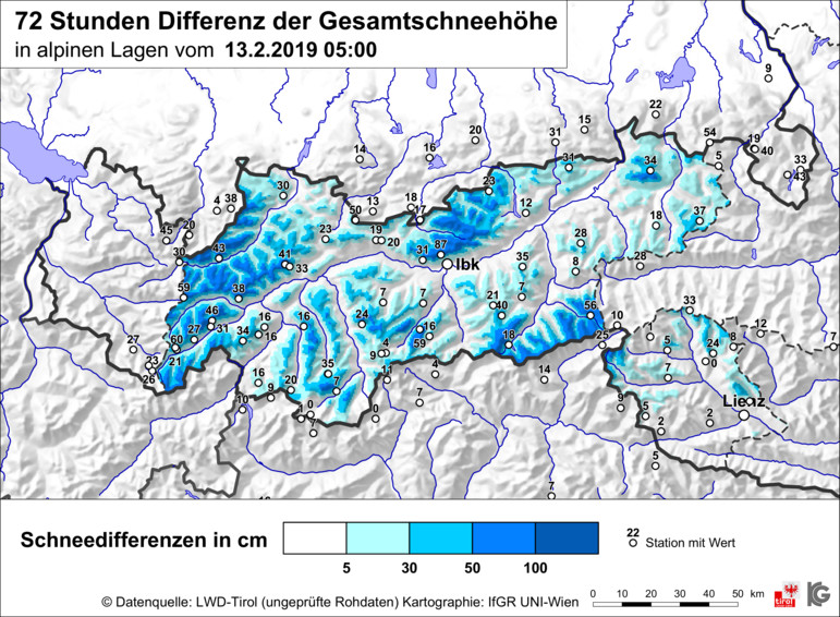
Caution: fresh snowdrifts in very steep, shady ridgeline terrain. Beware loose + glide-snow avalanches!
A new round of fresh snow was unloaded on Tirol, most in the northern, eastern and furthermost western regions, as well as in the eastern Zillertal Alps. Frequently between 30 and 50 cm of fresh snow was registered, the prize was won by the Seegrube measurement station above Innsbruck (once again): just under 100 cm.…
-
Avalanche forecast in 3 languages: the phrase catalog
Avalanche warnings in the Alps Normal 0 21 false false false DE-AT X-NONE X-NONE The Alps are an extraordinarily complex mountain range, unique on earth. In no other mountain range of the world do so many countries and cultures meet in such a compressed area. Eight nations with five highly contrasting languages share a space…
-
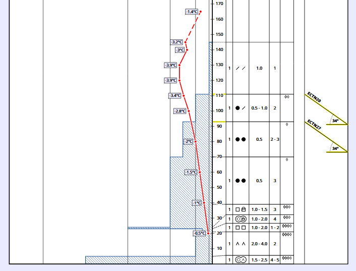
Weak old-snow layers demand caution. Gliding snow increasing.
Current situation Weak layers in the old snow are currently the main problem for winter sports in Tirol’s mountains. In East Tirol, separate from the Main Alpine Ridge, the old-snow problem is striking. Due to the shallow snowpack at the end of January, markedly weak layers formed near ground level consisting of faceted snow crystals…
-
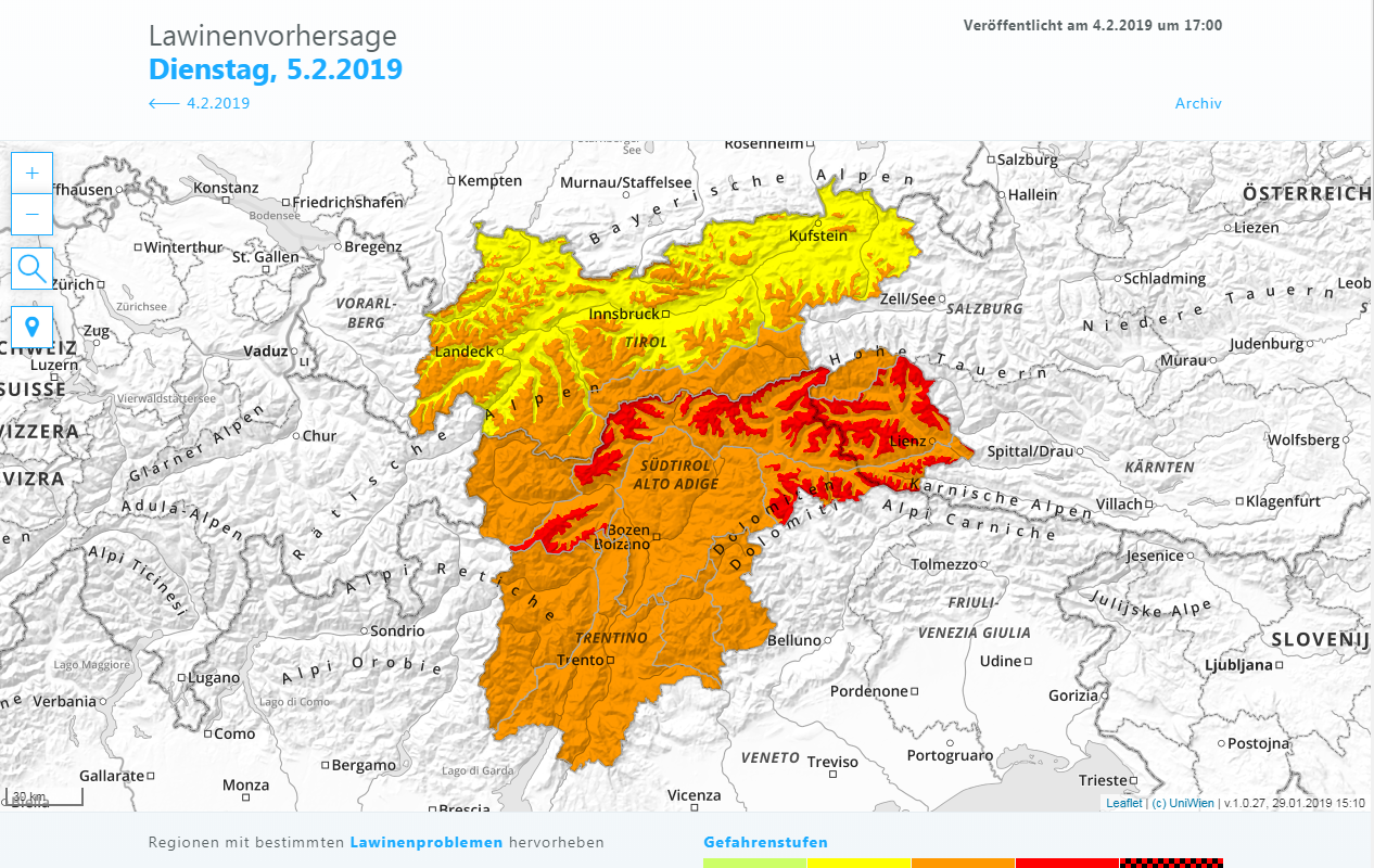
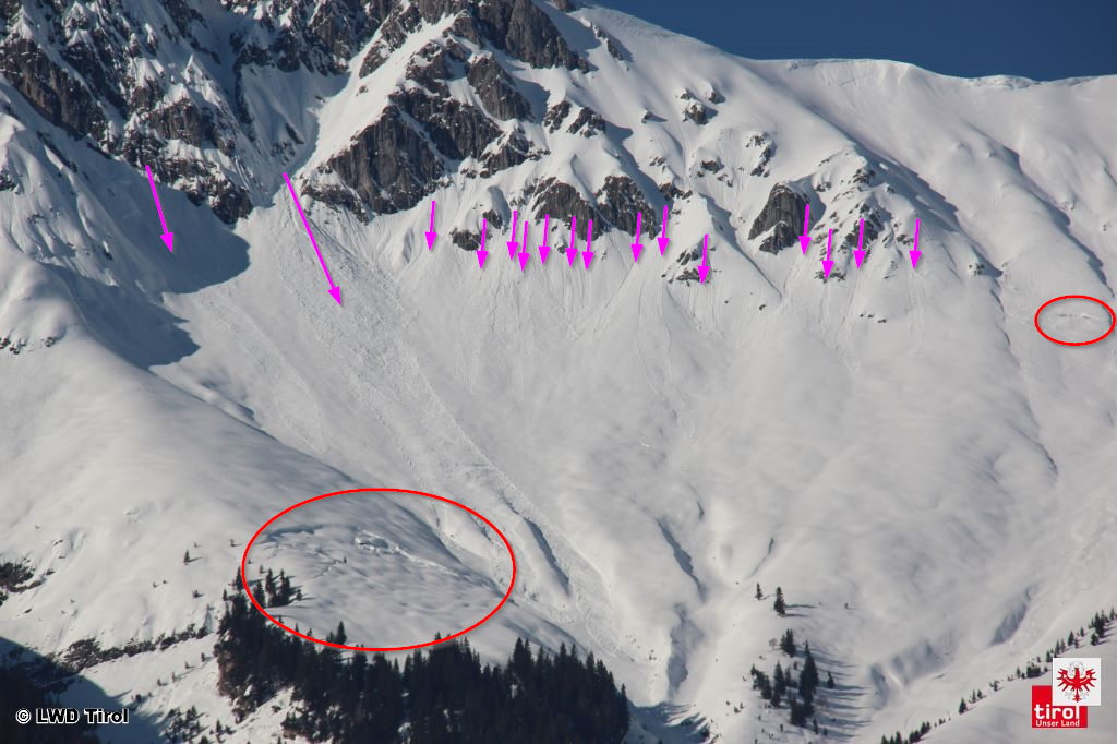
Numerous avalanches in Tirol exhort caution, esp. in central + southern East Tirol
Numerous avalanches During the last few days, numerous avalanches in Tirol have been registered. These were naturally triggered releases in the regions where snowfall has been heaviest, on the one hand; on the other, avalanches triggered by skiers and freeriders. To date, no one has suffered injuries. In the interim, the phase of naturally triggered…