Category: Current situation
-
Attention: other alpine dangers (not avalanches)
Springtime conditions The beautiful weather and clear nights will give us classic springtime conditions starting on Sunday, 28 February. In early morning, conditions are favorable. Avalanche danger subsequently increases somewhat due to daytime warming and solar radiation. Naturally triggered avalanche activity has receded compared to last week. Winter sports enthusiasts can still trigger slab avalanches,…
-

Main danger: glide-snow avalanches. Heed daytime danger cycle!
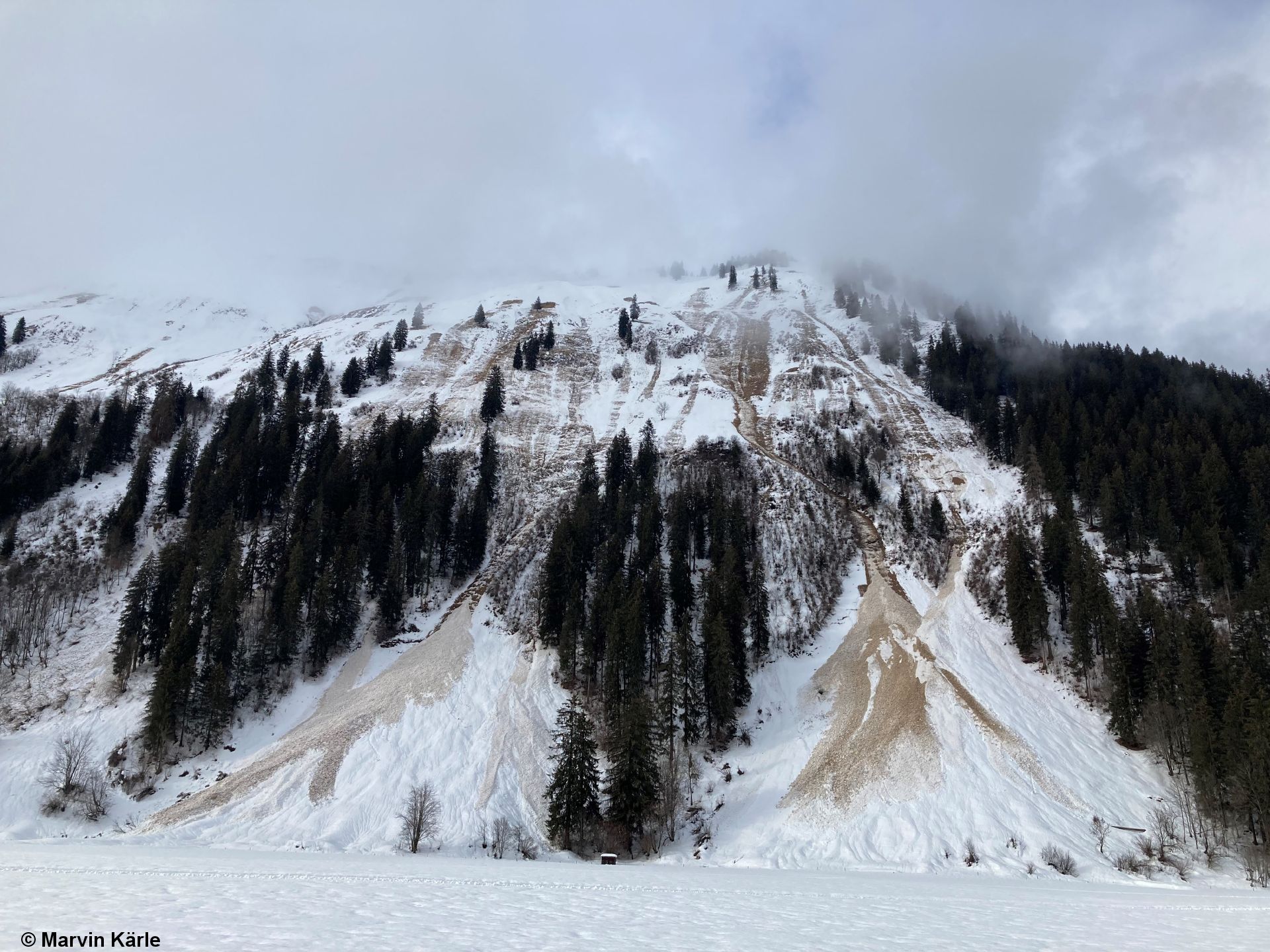
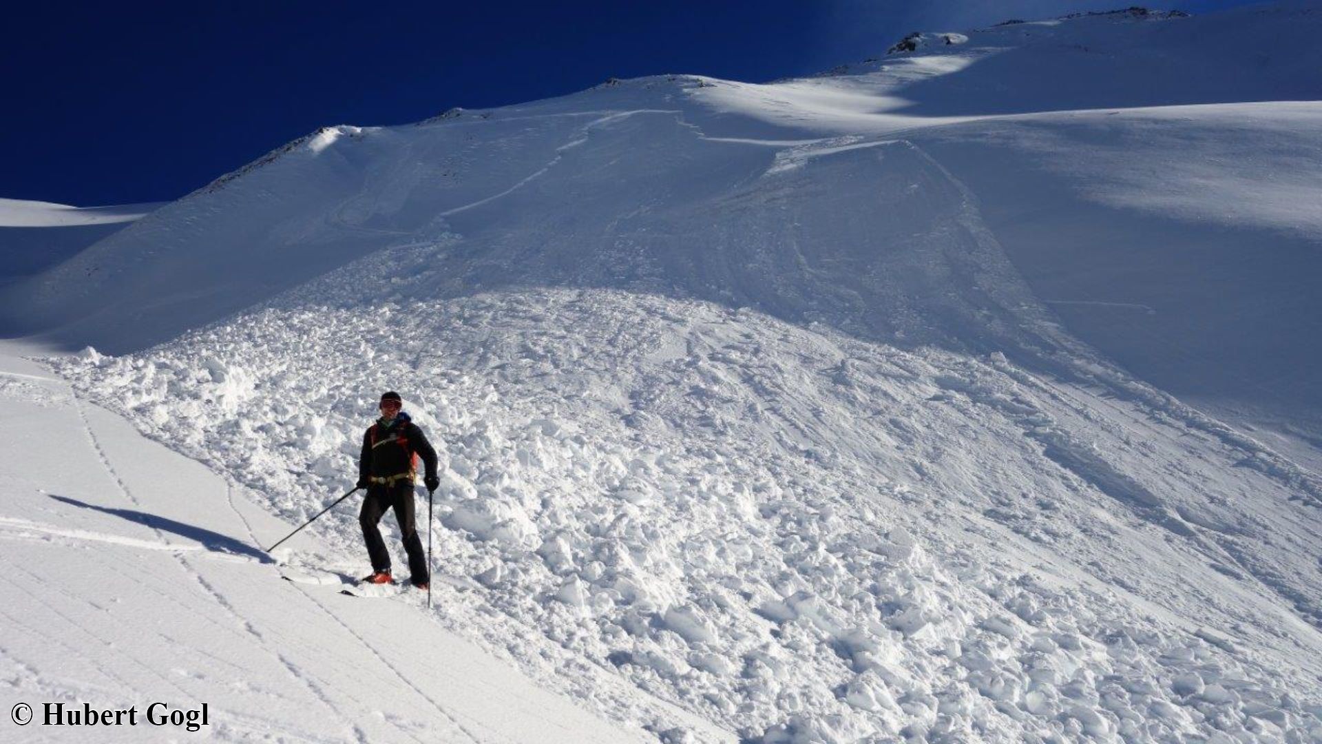
Numerous naturally triggered avalanches Numerous avalanches unleashed naturally in Tirol during this last week. These occurred primarily on steep, sunny slopes up to altitudes of approximately 2700 m. Wet-snow and glide-snow avalanches were frequently observed below about 2400 m. Deposits of fresh wet-snow avalanches on Fliesser Berg, south, 2100 m (photo: 23.02.2021) Slab, glide-snow and loosely-snow…
-

Caution: glide-snow avalanches possible at any time of day or night. Hiking trails, forest roads at risk
Snowpack forfeits firmness due to water seepage As a result of above-average temperatures and solar radiation, a progressive wetness of the snowpack can be observed. This applies particularly to sunny slopes below 2600 m, shady slopes below 1800 m. Indicative of the current situation: steadily rising temperatures over the last few days. Snowpack-surface temperature is…
-
Increasingly favorable situation, slight daytime cycle of rising danger
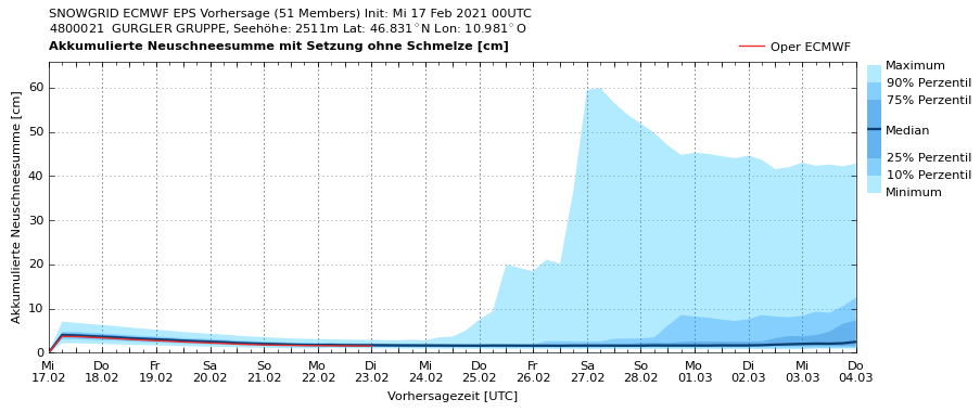
Coming soon: a stable high-pressure weather front According to ZAMG Weather Service forcasts, high-pressure conditions will increase ongoingly over the next few days. On Friday, 19.02, a cold front over Germany will send some clouds to Tirol. Starting on Saturday, 20.02, a stable high-pressure weather front will take over the reins. The zero-degree level is…
-
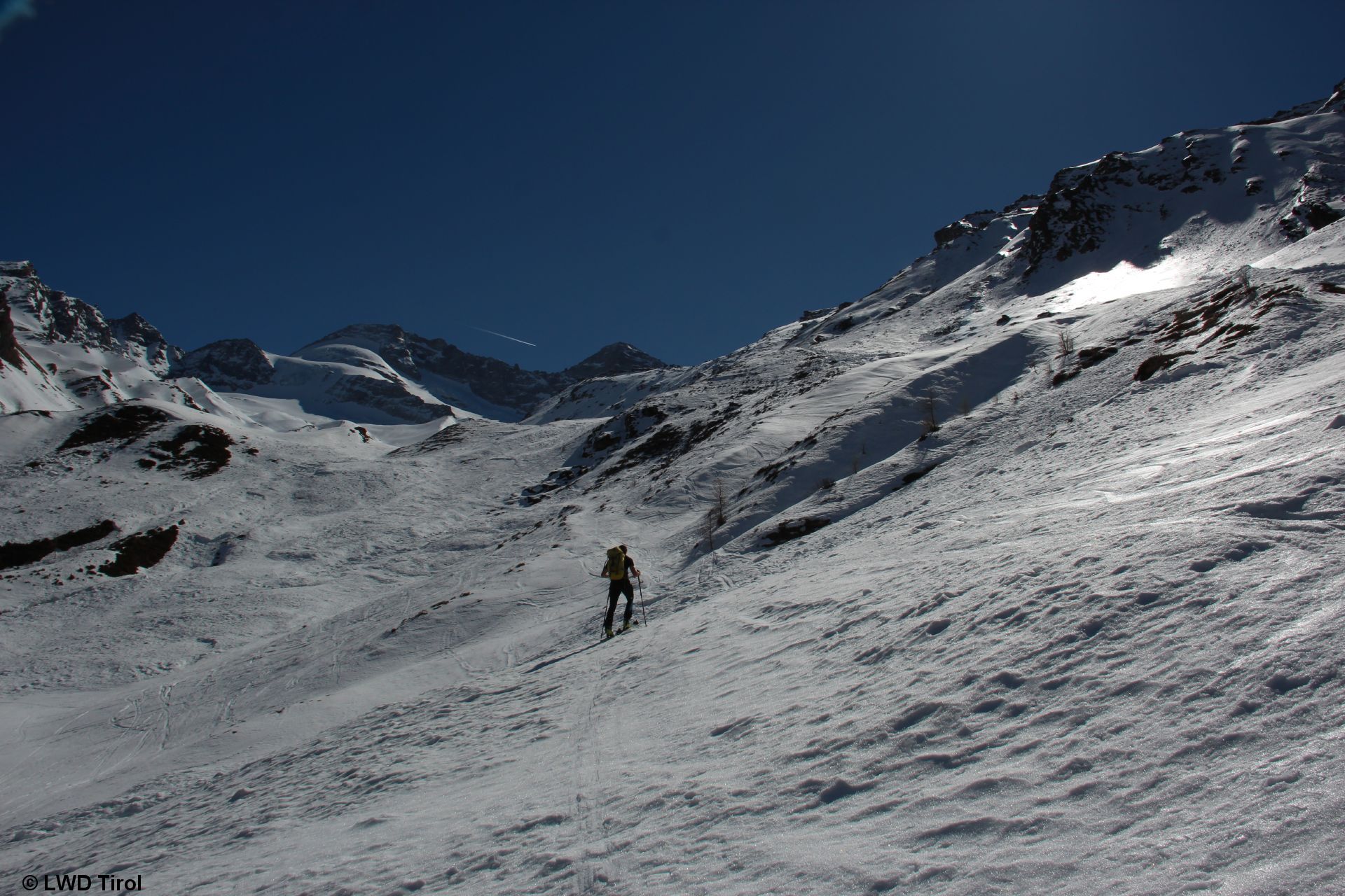
Fresh snowdrifts, loose-snow avalanches, still weak old snow regionally
Fresh, trigger-sensitive snowdrifts The combination of cold temperatures, loose, dry fluffy fresh snow and wind reinforces the forming of trigger-sensitive snowdrift accumulations. These are currently most wide-ranging in East Tirol and the southern Ötztal Alps where recent snowfall was heaviest. With some experience in assessing dangers on-site, these spots are easy to recognize and circumvent.…
-
Springlike conditions: daytime danger cycle. Ongoing old-snow problem. Analysis of fatal accidents. Review.
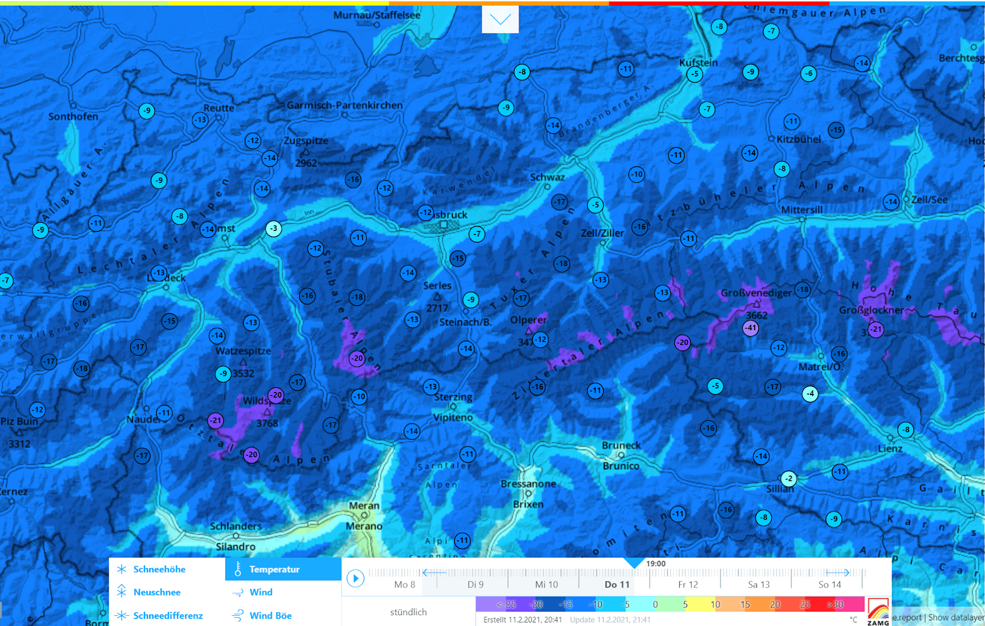
Attention: daytime avalanche danger cycle At the moment (4 February) we are experiencing an unseasonably warm weather phase. The snowpack at low and intermediate altitudes, which was already moist, is slowly becoming thoroughly wet. On sunny slopes the moisture content of the uppermost layers is marching forward, up to higher altitudes. More moisture in the…
-

Delicate situation regionally for winter sports enthusiasts. Two fatal avalanche accidents in Stubai Alps.
Numerous naturally triggered avalanches We have just completed a phase of numerous naturally triggered avalanches. Some were very large and swept over exposed transportation routes, primarily in the western regions where snowfall was heaviest. Due to higher temperatures and rain impact, glide-snow avalanches have also increased. Particularly in East Tirol where snowfall has been heavy,…
-
Help us avoid unnecessary rescue operations – Please report all “non-injury” avalanches to headquarters!
Avalanches involving persons with definitely no injuries, i.e. where help is unnecessary, are called “negative avalanches” by Avalanche Headquarters in Tirol. In order to avoid all cost-intensive avalanche operations, we appeal to winter sports enthusiasts to report all negative avalanches to headquarters. Please call Avalanche Emergency tel. no. 140 to report these directly! Please also…
-
Warm front + snowfall + storm wind leading to significant increase in avalanche danger. Naturally triggered avalanches expected.
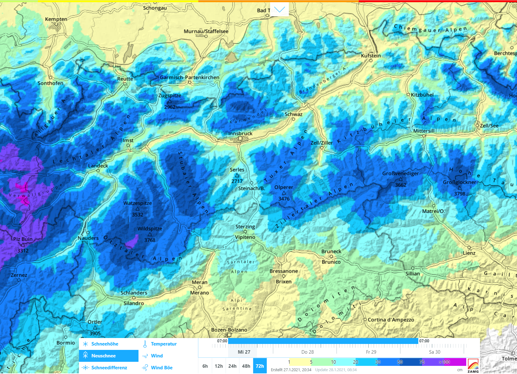
Breaking news: Big daytime rise in risks today (28.01.21). High avalanche danger. A warm front from the Atlantic has been generating our weather conditions since yesterday (27.01) and, consequently, also our avalanche conditions. Most of the precipitation is anticipated in the western, also in the northern regions of North Tirol. ZAMG Weather Service forecasts 40-60 cm…
-
Tense avalanche situation for winter sports enthusiasts. Avalanche analysis and outlook.
First things first: the delicate, treacherous avalanche situation will persist for winter sports enthusiasts. So we continue to advise: high restraint in outlying terrain! Numerous reports from winter sports enthusiasts, ardent snowpack examinations and meticulous accident analysis all confirm, unfortunately, that the avalanche situation for winter sports enthusiasts remains very tense. Making things worse, the…