Category: Current situation
-

Winter Greetings in high alpine regions – Time to sharpen your sense of winter dangers
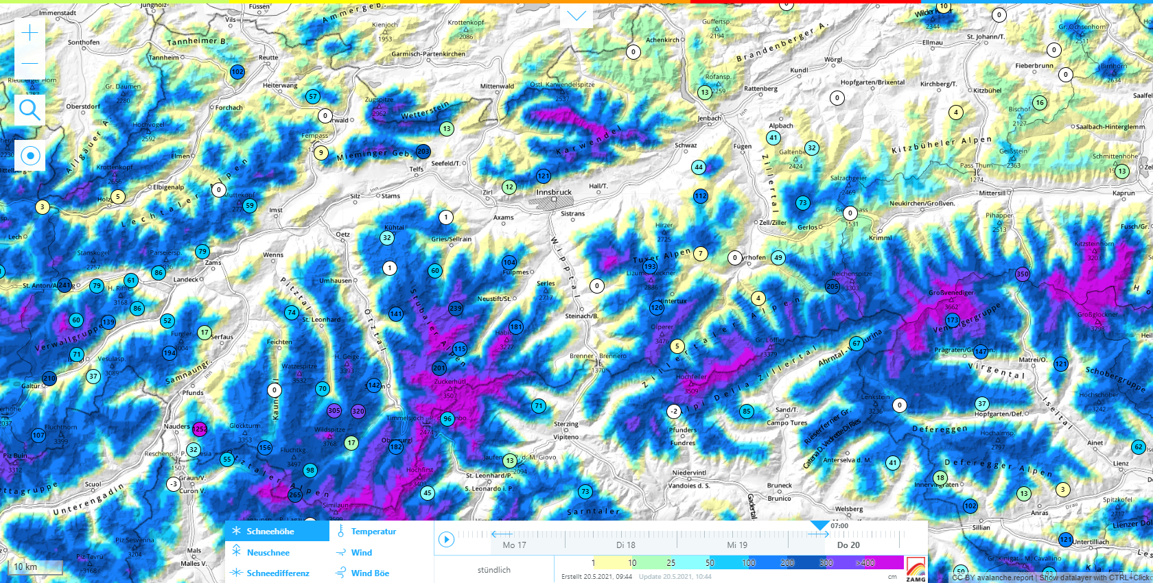
Cold front brings snow to high alpine regions Following stormy bouts with a southerly foehn wind, then a cold front, it turned wintery along the Main Alpine Ridge in Tirol. Between 04.10 and 07.10.2021, measurement stations registered generally between 20 and 80 mm of precipitation, in some cases more than 100 mm. However, due to…
-

Ongoing winter in high alpine regions • Avalanches still a concern
Coolest spring for at least 25 years – Still lots of snow in the mountains The ZAMG Weather Service recently informed us that spring 2021 is the coolest we have had in the last quarter of a century at least. Similar temperatures prevailed for the last time in 1996 and 1991, a notch cooler still…
-
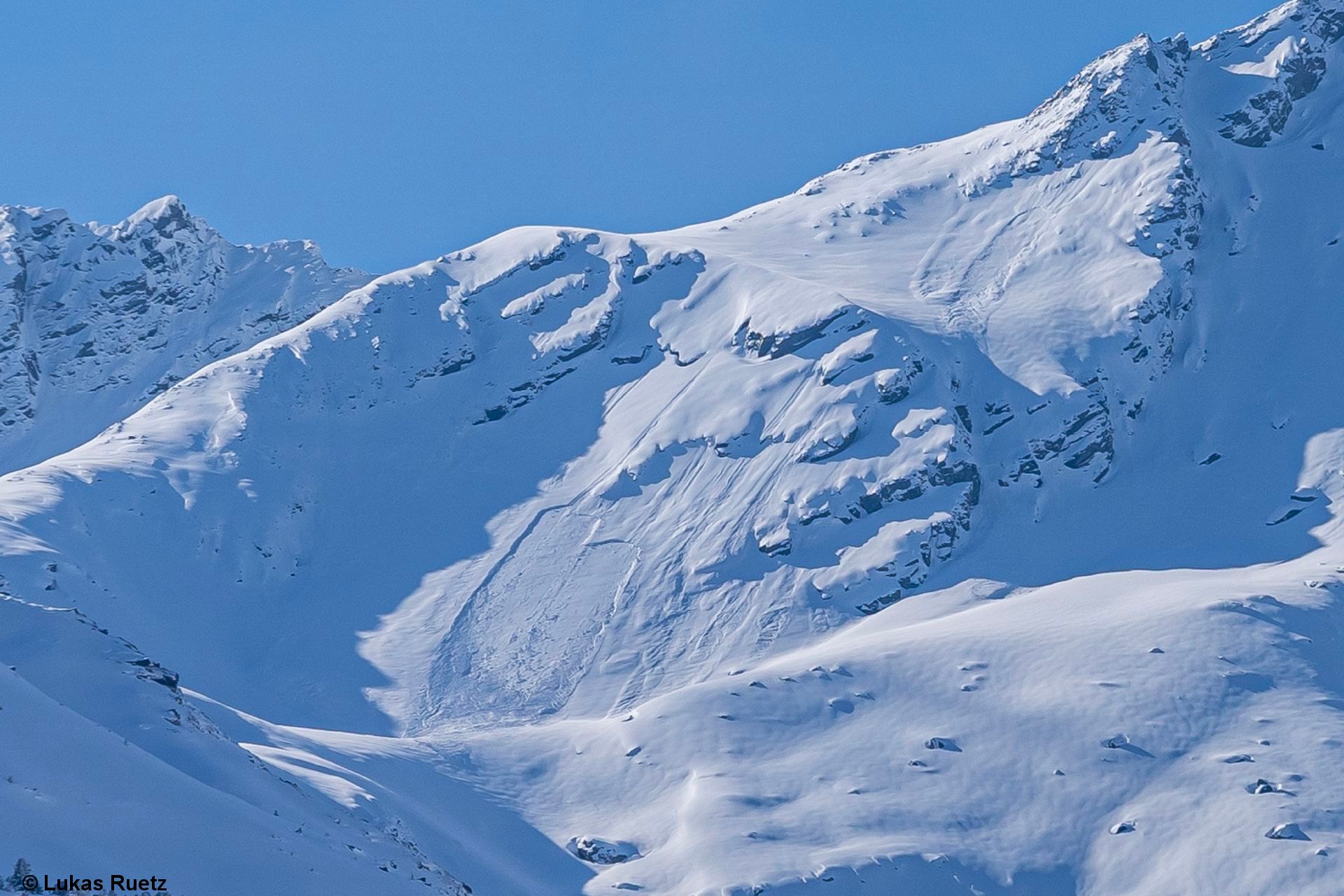
Still wintery in high alpine regions – Avalanche danger requires attentiveness
Regionally still lots of snow in the mountains During a period of overly cool, highly variable weather, the snow depths in high alpine regions are still increasing. Very wintery conditions continue to reign there unchangingly. This coincides with the reports of ZAMG Weather Service: spring was this cool in 1996 and 1991. Overall snow depths…
-

Foehn collapses – Fresh snow + wind ratchet up avalanche danger
The winter just doesn’t want to stop… Over the last few days, a strong southerly foehn wind was blowing in the mountains. Today (11.05) the foehn collapsed. In the southern regions, precipitation has set in. In the northern regions a cold front from the west will move in during the evening/nighttime hours. Windspeeds reach nearly…
-

Still wintery in the mountains – Very warm weekend ahead – Rising danger of wet-snow avalanches
Sudden warmth impulse harbors heightened wet-snow avalanche potential Still lots of snow in the mountains The ZAMG Weather Service today published a notice of striking and powerful impulses of warmth which will bring about increased snowmelt between Sunday, 9 May and latest Wednesday, 12 May. It is a result of the still immense amounts of…
-
Rather unfavorable avalanche conditions, frequently poor snow quality
Snowpack becoming increasingly wet – Likelihood of naturally triggered avalanches rising Over the last few days it was quite warm, amid variable weather conditions. The snowpack became ever moister, also at high altitudes, thoroughly wet even down to lower layers. In the southern regions this was not the case, due to temporarily poor weather. It…
-
Springtime conditions, heightened increase in avalanche danger, good timing more important than ever!
A sunny weekend awaits us. Caution towards wet-snow avalanches during course of day! Following a typical variable period of April weather bringing us rainfall regionally up to 2000m in many northern regions, today on 22.04 weather conditions are now improving. During the night, skies will begin to clear. On Friday and Saturday, sunny and warm…
-
After dreamlike powder, now heightened caution on shady slopes
Diffuse radiation raises likelihood of triggering on shady slopes – Caution urged esp. at 2200-2600m As was amply evident in the most recent blogs, it was possible to savor superb powder snow in many areas on shady slopes amid low temperatures last week. As of today, 19.04, the sun appeared frequently between the clouds. This,…
-
Much powder currently, quite good conditions. Locally, treacherous avalanche situation expected (dp.4 – cold on warm)
New weak layers possibly forming The recent instable weather with its immense temperature fluctuations is giving us a headache. The reason: it provides perfect prerequisites for Danger Pattern “cold on warm” (dp.4). This syndrome is known for forming weak layers inside the snowpack after a certain post-snowfall period. As of today, 15.04.2021, we have evidence which…
-
Main danger: fresh drifts and loose-snow avalanches
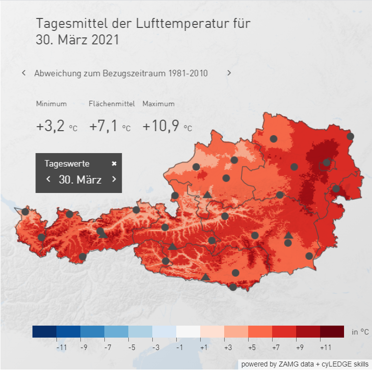
Temperature progression…far removed from normal Yes, this is April, and April is well known for capricious weather. Even taking that into consideration, we gaze back on a highly ususual sequence of temperature development. Let’s permit an expert at ZAMG Weather Service, Alexander Radlherr, to elucidate just what happened: “The ups and downs in temperature were…