Author: Jeffrey McCabe
-

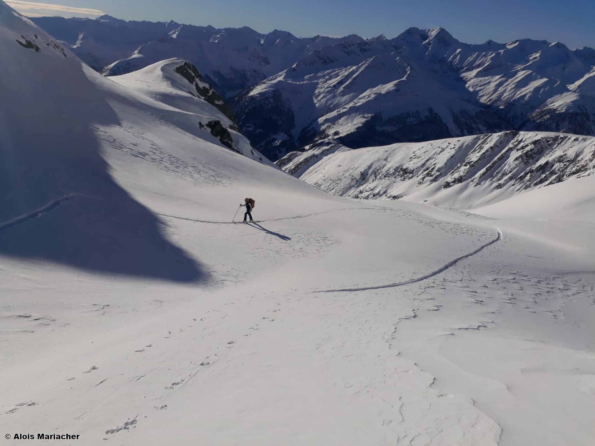
Favourable avalanche situation widespread. Snow quality is deteriorating.
Weather Overview High-pressure conditions predominate Last week enjoyed the impact of a stable high-pressure front with only brief interruptions. Temperatures were above average for this juncture of the season. Little change in this scenario is anticipated over the next few days. A weak cold front on 10.01 will bring some precipitation in the evening as…
-
Snowfall + wind: rising avalanche danger
Following a week of high-pressure weather conditions and generally quite favourable conditions, winter sports enthusiasts have to realign their sights: starting on 4 January wind and snowfall will swiftly lead to heightened avalanche danger. Freshly generated snowdrifts on W/N/E facing slopes, particularly in wind-protected zones, will be easily triggered by backcountry skiers and freeriders. The…
-
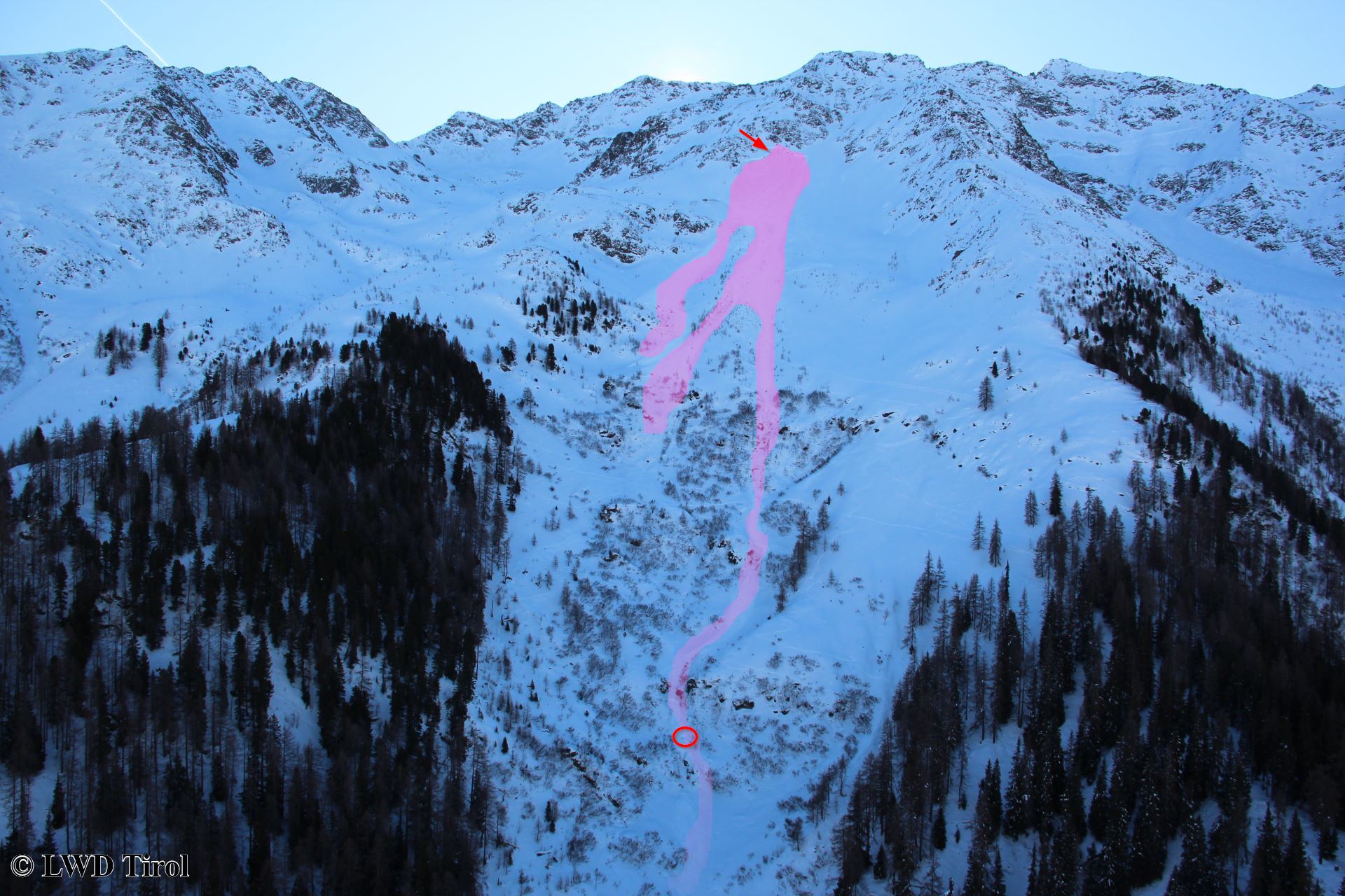
Avalanche accident Gamskarspitze, Western Verwall Massif, 31.12.19
On 31.12.2019, Tirol headquarters reported an avalanche below the Gamskarspitze in the western Verwall Massif just after 1:30 pm. One person was caught by the avalanche, was swept along several hundred metres and completely buried. The person died on the scene of the accident. On 01.01 we were on-site with the state helicopter together with…
-
Peak of avalanche danger has passed. Main perils: high-altitude snowdrifts, gliding snow below 2600 m
An intermediate high on Boxing Day brings the stormy bouts of snowfall forecast by ZAMG Weather Service to a close. The apogee of avalanche danger is now been passed, over the next few days, avalanche danger will incrementally diminish. The main problems: fresh and older snowdrift accumulations at high altitudes, on the one hand; gliding…
-
A Christmas present – new things in the avalanche report
Last winter the cross-border Internet website of the Euregio Avalanche Bulletin was launched. The enormous extent it was accessed, together with 3500 reader feedback reactions in the online survey at the end of March 2019, confirm the high degree of acceptance of the site. In addition we received lots of stimulating suggestions and proposals for…
-
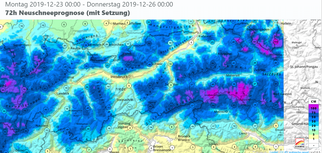
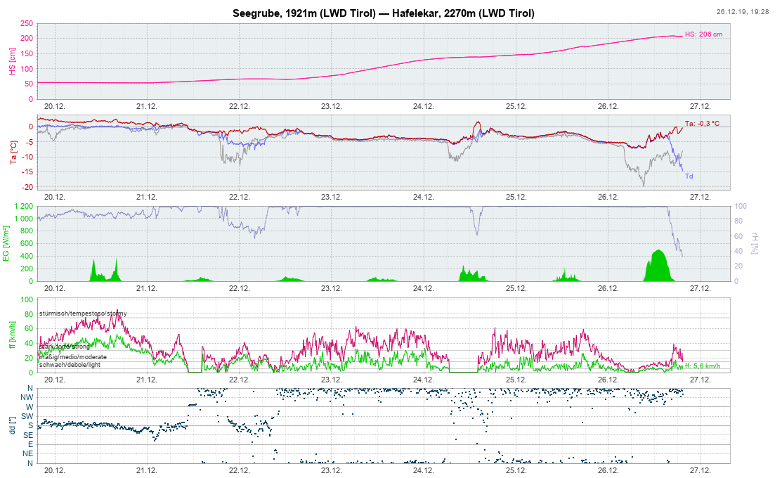
Stormy NW air current bringing heavy snowfall regionally, plus rain. Avalanche danger increasing!
Precipitation, winds, temperature fluctuations The persistent southerly air current with precipitation along the Main Alpine Ridge and in East Tirol has been replaced by a NW air current. The ZAMG Weather Service warns of snowfall and rainfall between 22.12 6:00 pm and 25.12.2019 6:00 pm, most of which is expected to fall in the Silvretta,…
-
Limited danger zones, generally poor snow quality
Last week bore the imprint of southerly air currents. At high altitudes, lots of snow was transported. The freshly generated snowdrift accumulations were easily triggered to start with. The unseasonably mild temperatures then improved the situation. The main problems this week were small glide-snow avalanches and moist slides, also distant-from-ridgeline snowdrifts at high altitude and…
-
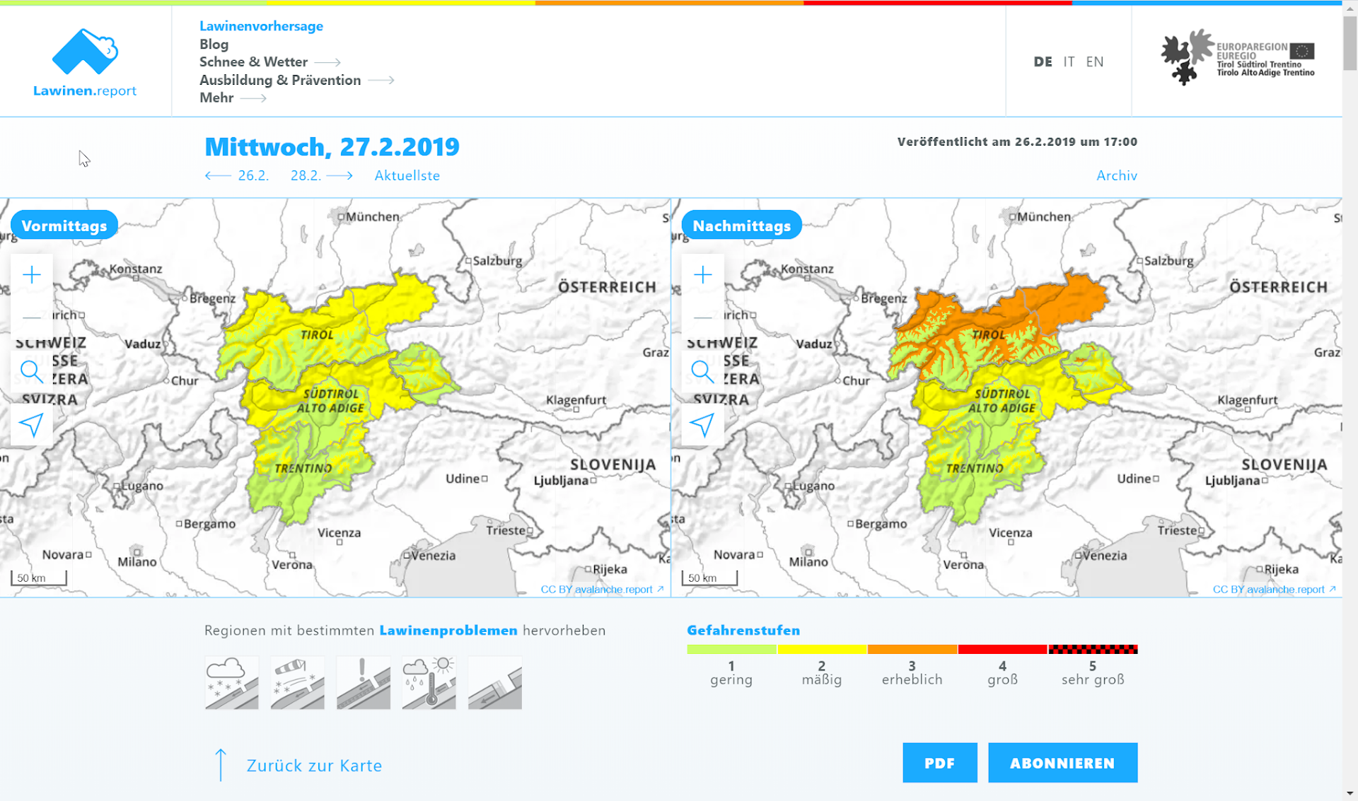
Regionally wintery. Main danger: fresh snowdrifts above treeline
The generally favourable conditions have deteriorated since last week as a result of snowfall and wind impact. Regionally there has been considerable avalanche danger. In East Tirol, favourable conditions still reign, but are now receding as a result of wind and some fresh snow. Weather review Variable conditions. That is the best way to describe…
-
Ongoingly favourable avalanche situation
The favourable avalanche situation in Tirol persists. Even the weak cold front which is expected to brush Tirol on 7 December will not change anything significantly through Sunday, 8 December. The intensifying wind at high altitudes might generate fresh, relatively small snowdrift masses. These will sometimes be relatively easy to trigger, but can be easily…
-
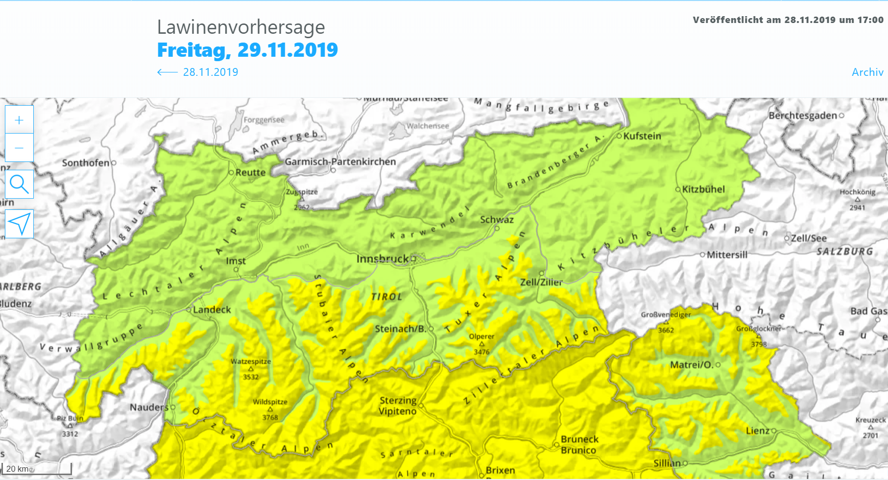
Mostly favourable conditions – isolated glide-snow avalanches in regions where snowfall was heaviest. Fresh snowdrifts, esp.in the west.
Mostly favourable conditions Numerous examinations of the snowpack and reports from observers corroborate the assessment: the avalanche situation is improving to an increasing degree. The snowpack is stable over widespread areas. Weak layers are found only in isolated cases, and then, they are near to the surface at very high altitudes in the immediate vicinity…