Author: Jeffrey McCabe
-
Recent avalanches mostly in NE/E/SE aspects above 2500m (persistent weak layer) – Heed daytime danger cycle
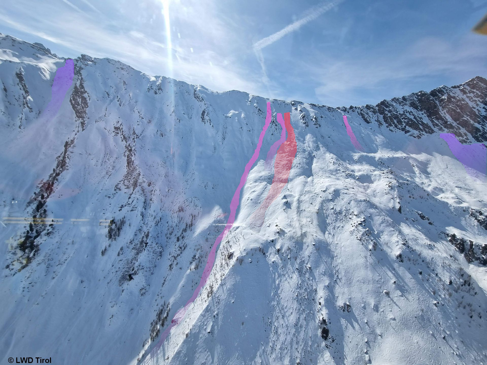
Summing it up Several avalanches have been triggered by winter sports enthusiasts during the last few days, increasingly on very steep slopes above 2500m in NE/E/SE aspects. The heightened proneness to triggering of weak layers inside the snowpack was the result of pronounced slabs (see last blog) which formed recently. Most avalanches releases were caused by a…
-
Thorough wetness is weakening the snowpack – More pronounced daytime danger cycle
To start off Mild weather during the next few days is intensifying the wet-snow problem. Wetness seeping into snowpack is weakening it. Avalanches can more easily be triggered by winter sports enthusiasts. Also naturally triggered avalanches are more likely. Crucial: good tour planning, reasonable time allotment, adequate equipment and experience in assessing avalanche danger on-site.…
-
Variable weather – Variable snowpack
The overall picture Springtime is well known to have a few surprises up its sleeve. Accordingly, the snowpack can moisten thoroughly (at least the surface layer) within the shortest imaginable time due to diffuse radiation, increased air moisture and higher temperatures. This, in turn, transforms the slab. Or else, water seeps down into the snowpack…
-
Generally favorable avalanche conditions – Little snow in many places – Danger Pattern “cold on warm” frequently developing
Summing it up Since yesterday, 01.03.2023, the avalanche danger level in Tirol has been low. We assume there are only few danger zones where avalanches can be triggered, if at all, then on shady slopes at high altitudes. Nevertheless, we are currently observing the development of a potential weak layer due to Danger Pattern “cold…
-
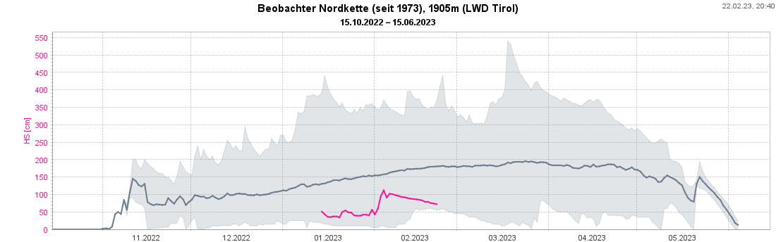
Much too little snow for this juncture of the season – Persistent weak layer esp. on very steep shady slopes near ridgelines – Minor snowdrift problem on the weekend
In short: The lack of precipitation this winter is quite striking in the snow cover. For this juncture of the season there is much too little snow on the ground, not only here in Tirol but in far-reaching parts of the Alps. See also the Blog of our colleagues in Switzerland. Avalanche danger levels are moderate, particularly on…
-
Persistently treacherous – persistent weak layer
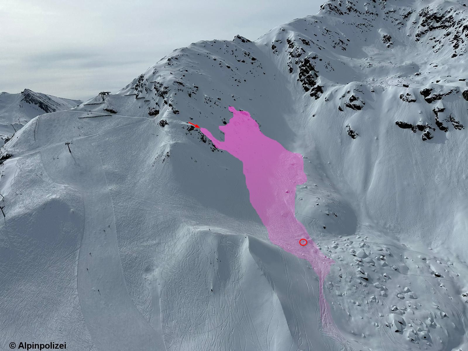
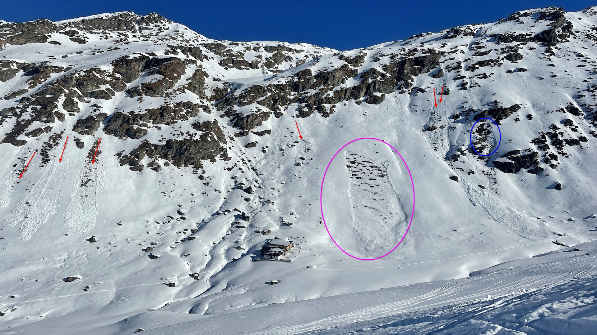
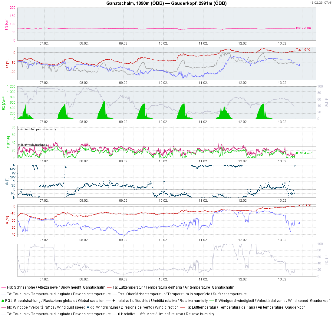
To start off: The persistent weak layer which has persisted for a long period is still of significance for avalanche releases in isolated cases. This was amply demonstrated last week by several avalanche triggerings in which persons were involved. Wednesday, 15.02.2023: negative avalanche Gstreinjöchl, Ridnaun Massif Thursday, 16.02.2023: negative avalanche Pfaffenbichl, western Tux Alps Saturday, 18.02.2023: two negative avalanches…
-
Quite good conditions in general. Slight loss of firmness in places due to solar radiation and daytime warming
To sum it up: Danger zones especially in little-tracked shady very steep terrain During the last few days, Avalanche Headquarters Tirol received only isolated reports of avalanches involving persons (no injuries). Moreover, most snowpack analysis in the interim demonstrates a lack of tension inside the snowpack. Thus, we can assume there are only limited avalanche…
-
Persistent weak layer in some places – Slight daytime danger cycle for avalanche risks due to solar radiation and rising temperatures
Before all else: Besides persistent weak layer problem, daytime loss of snowpack-surface firmness Last week’s biggest threat, the persistent weak layer, remains with us above 2000m. In the interim, frequency of avalanche prone locations where slabs can be triggered has diminished significantly. Avalanches are mostly triggerable on very steep slopes in transition zones from shallow…
-

Analysis of deadly avalanches. Current situation treacherous.
Avalanche time The term “avalanche time” has locked a heavy stamp on the education of Austrian mountain and ski guides. It designates the short period in a winter season which bears far higher risks of avalanches. Just such a period was what we had between 3rd and 6th of February. Within that short time, 8…
-
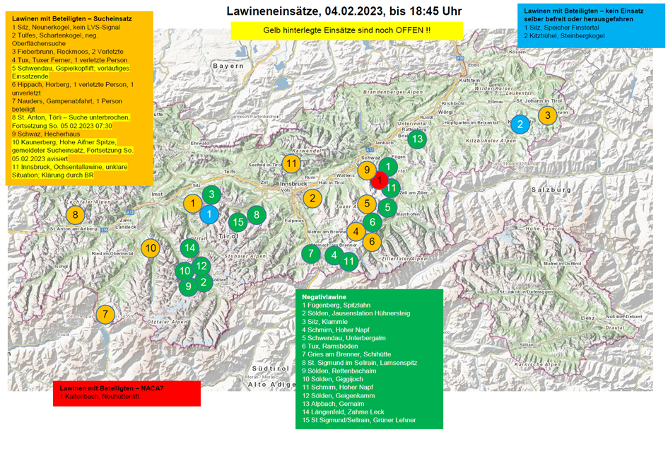
Numerous avalanches – also fatalities. Successful artificial triggerings. Cluster risk in open terrain.
Numerous avalanches involving persons We are facing an extraordinary and dangerous situation for winter sports enthusiasts, with high avalanche danger above 1600 m. Confirmation of this during the last two days came from numerous avalanches in which persons were involved. This morning (04.02) there were 29 reports made to headquarters in Tirol. Yesterday (03.02) there…