Lawinenunglück Wetterkreuz - Gilfert (© BR Mayrhofen, 11.01.2026)

Sunday, 11.01.2026, numerous alarm signals: avalanche releases, fractures, settling noises, remote triggerings / A fatal avalanche incident

Our forecasts of an extremely trigger-sensitive snowpack on Sunday, 11.01, have been fully confirmed. Among numerous avalanche releases with personal involvement, 1 person was killed and 2 were injured.

The regionally delicate avalanche situation and often highly prone-to-triggering snowpack will continue

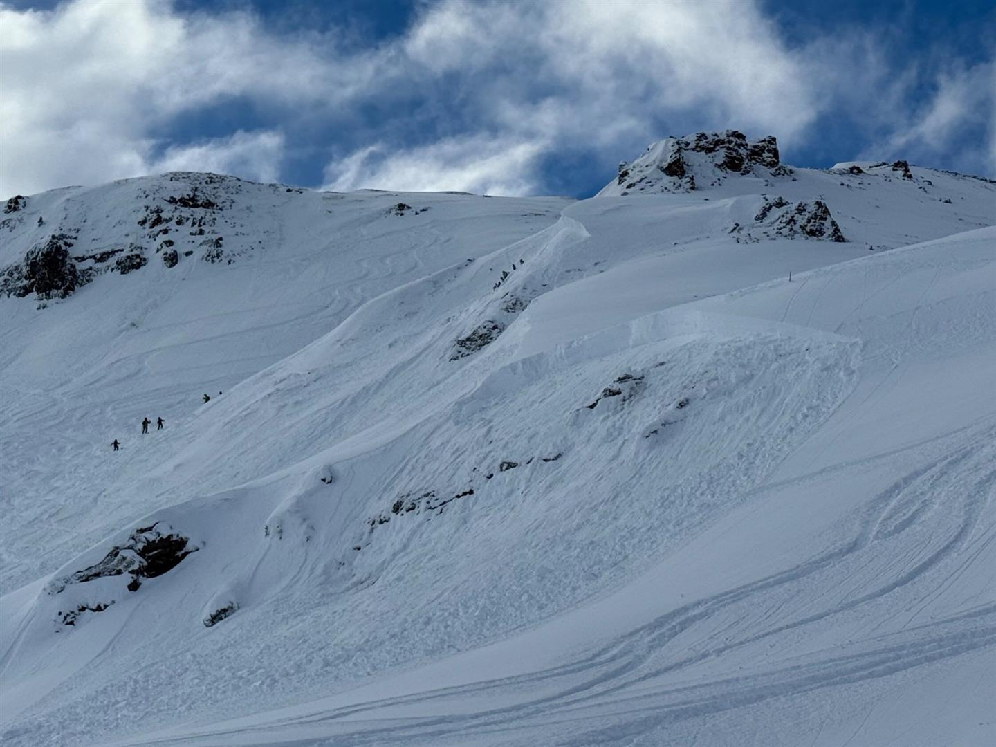
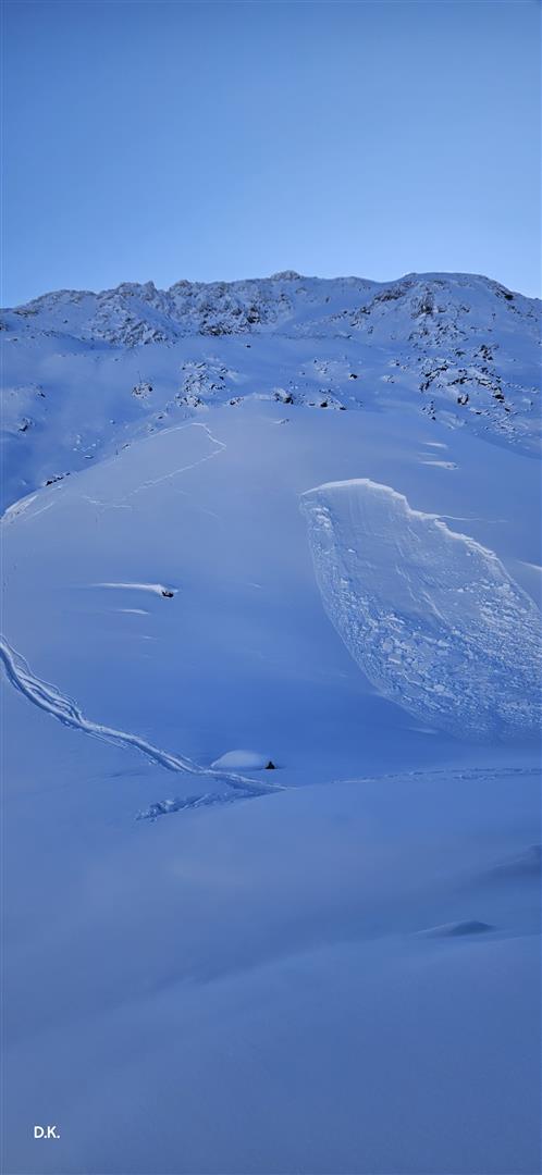
Avalanche releases: an overview

Not an ordinary day: at Headquarters Tirol, 15 avalanche releases involving persons (actual number of avalanches involving persons was certainly far higher.) A release below the Wetterkreuz near the Gilfert in the region “Tux Alps East” proved fatal. In two avalanches in the Arlberg region (Galzig and Kapall) one person was injured in each release.

Zusammenstellung der seitens der Leitstelle Tirol gemeldeten Lawinenabgänge am Sonntag, den 11.01.2026. Die erste Tagesmeldung wurde mit "1" , die letzte mit "15" angeführt. Schwarz hervorgehoben sind Lawinenabgänge, bei denen Personen von Lawinen erfasst wurden und bei denen ein Lawineneinsatz initiiert wurde. Weiß umrahmt sind die gemeldeten "Negativlawinen". Rot markiert ist der Lawinenabgang mit Todesfolge. (© Landeswarn- und Lagezentrum)
Summary of avalanches reported to Headquarters Tirol on Sunday, 11.01.2026. The first report is depicted by “1”, the last by “15”. Avalanches which caught persons and which unleashed avalanche searches are marked in black. Reported “negative avalanches” are marked in white. The avalanche which suffered a fatality is marked in red. (© Landeswarn- und Lagezentrum)

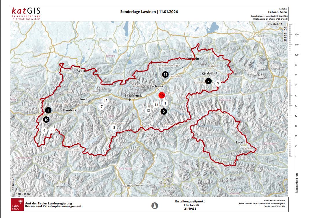
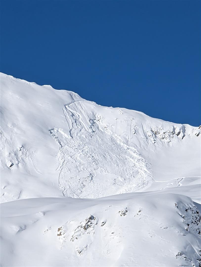
Fatal avalanche incident Wetterkreuz – Gilfert

Further details of the fatal avalanche incident will be published in an analysis in its own blog. The analysis will be conducted over the coming days together with the Alpine Police, dependent on weather conditions.

It is already clear that it was a slab avalanche which released below the Wetterkreuz in the vicinity of the Gilfert in the region “Tux Alps East”. One person was buried in snow masses in a narrow trench (landscape drop) and due to a lack of a beamer was not able to be located before the organized search team made the discovery.

Lawinenabgang Wetterkreuz - Gilfert: Der Kreis zeigt die Verschüttungsstelle der verstorbenen Person. Das Foto wurde während des laufenden Sucheinsatzes aufgenommen. (© BR Mayrhofen, 11.01.2026)
Avalanche release Wetterkreuz – Gilfert: the circle shows the place the deceased person was buried in snow masses. The photo was taken during the search. (© BR Mayrhofen, 11.01.2026)

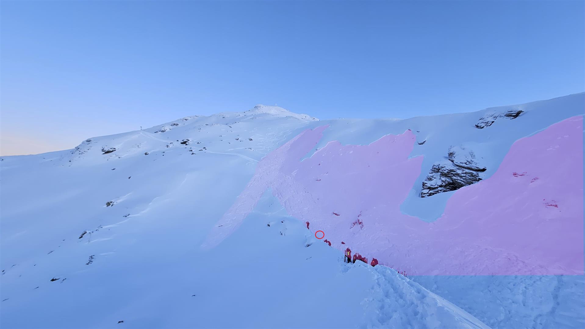
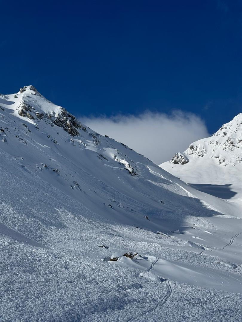
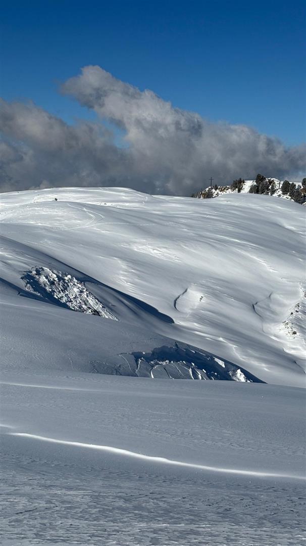
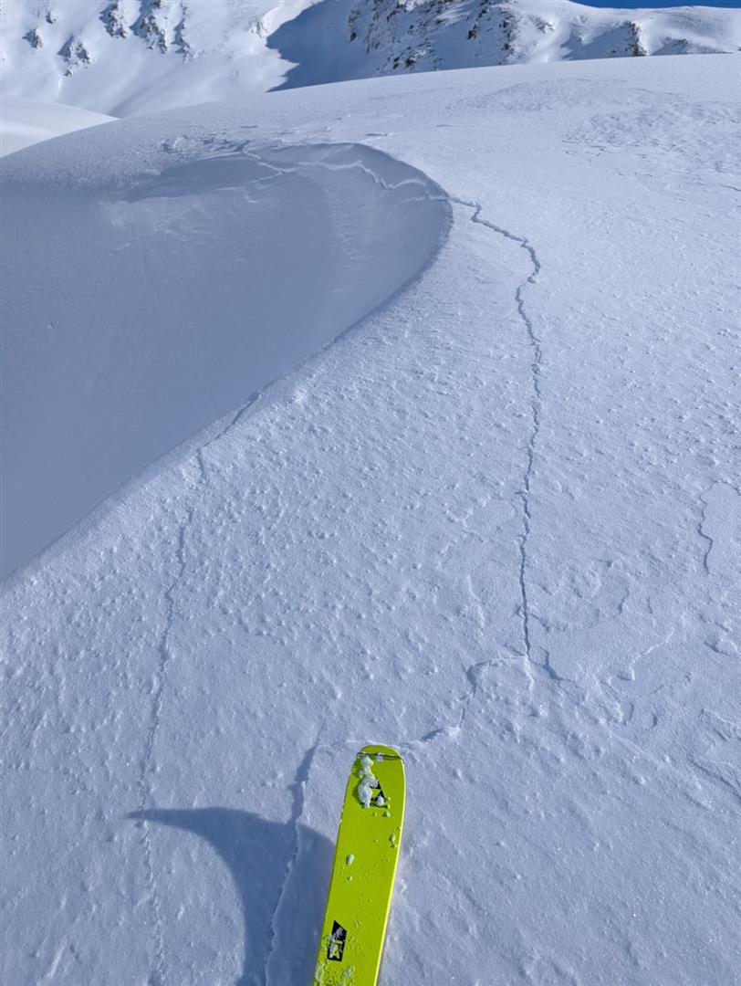
A selection of other avalanches

In the Kapall area of the Arlberg region a person was totally buried in snow masses and another person was superficially buried. The person who was totally buried was slightly injured and was flown to the hospital in Zams, the second person escaped without injuries. Since it could not be ruled out that a further person was caught in the avalanche, a large-scale search was organized, later brought to a halt without results.

Lawinenabgang Kapall. 2550m NO. (© Alpinpolizei, 11.01.2026)
Avalanche release Kapall. 2300m NE. In background, a further avalanche fracture is visible. It is possible that it triggered at the very same time. (© Alpinpolizei, 11.01.2026)
Kapall: Während des Sucheinsatzes (© Alpinpolizei, 11.01.2026)
Kapall: the emergency search (© Alpinpolizei, 11.01.2026)

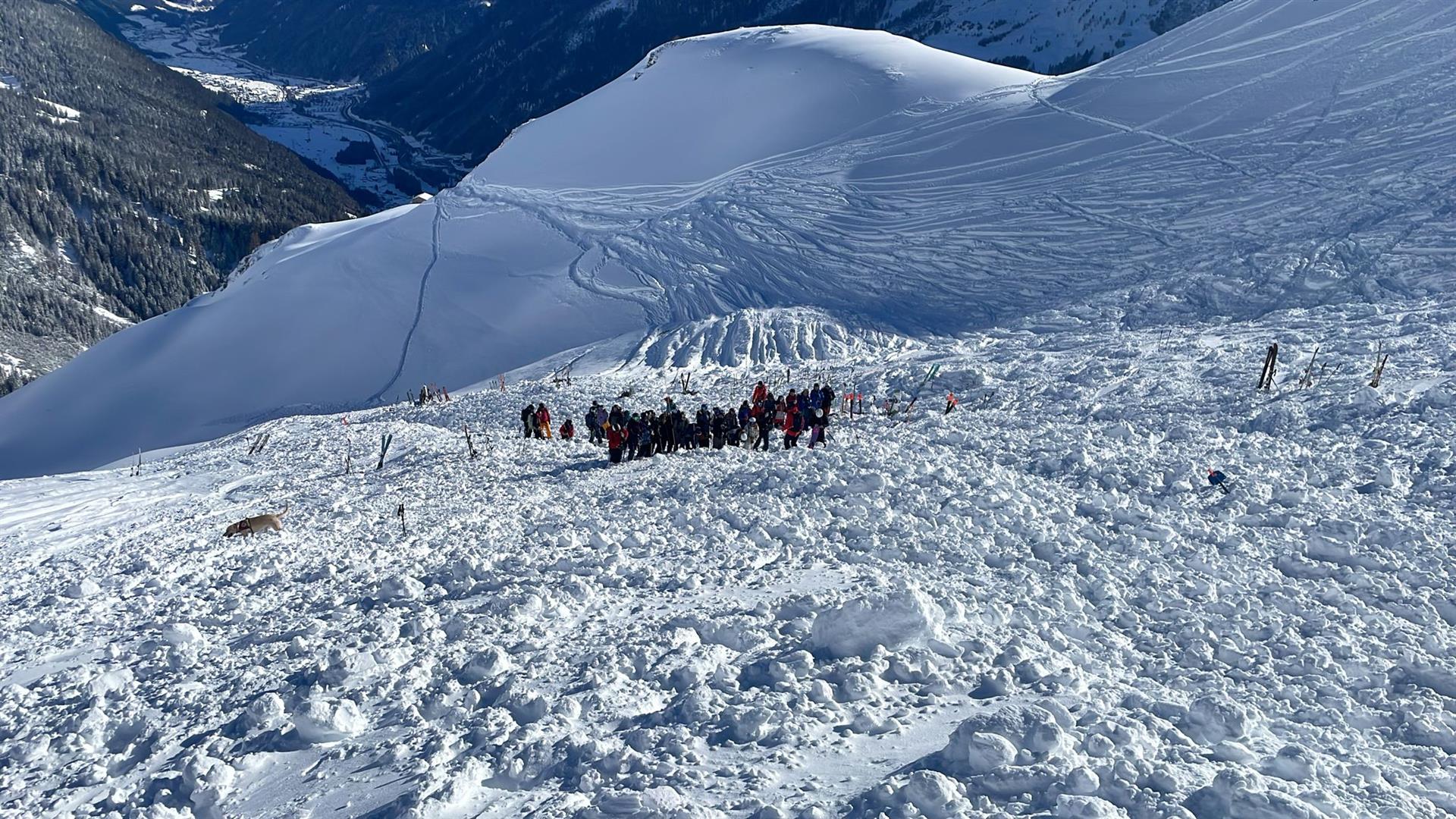
Below the Galzig, a slab avalanche triggered in the free-riding zone. One person was caught in its plummet path, buried in snow masses, and was flown to Zams Hospital with injuries.

Lawine Galzig: Lawinenanriss unterhalb des  Netzes im Variantenbereich (© Alpinpolizei, 11.01.2026)
Avalanche Galzig: fracture beneath the net in free-riding zone (© Alpinpolizei, 11.01.2026)
Lawinenauslösung mit beachtlicher Bruchfortpflanzung unterhalb des Peischelkopfes im Arlberggebiet. 2400m, S (© Peter Ehrengruber)
Avalanche triggered with remarkable fracture propagation beneath the Peischelkopf in Arlberg region. 2400m, S (© Peter Ehrengruber, 11.01.2026)
Fernauslösung aus flachem Gelände mit großflächiger Bruchausbreitung bei den Hohen Köpfen im hinteren Paznauntal (© Thomas Wanner, 11.01.2026)
Remote triggering with far-reaching fracture propagation on Hohen Köpfen in rear Paznauntal. 2500m, NE (© Thomas Wanner, 11.01.2026)
Lawinenauslösung Mitterzeigerkopf in der Grieskogelgruppe. Person konnte aus der Lawine ausfahren. 2600m, SO (© Lukas Ruetz, 11.01.2026).
Avalanche release Mitteerzeigerkopf in the Grieskogel Massif. A person was able to escape from the plummet path. 2600m, SE (© Lukas Ruetz, 11.01.2026).
Kleine fernausgelöste Lawinen beim Faltegartenkögele in der Grieskogelgruppe (© Kris Unterhauser)
Small remotely triggered avalanches on Faltegartenkögele in the Grieskogel Massif; 2200m, N (© Kris Unterhauser, 11.01.2026)

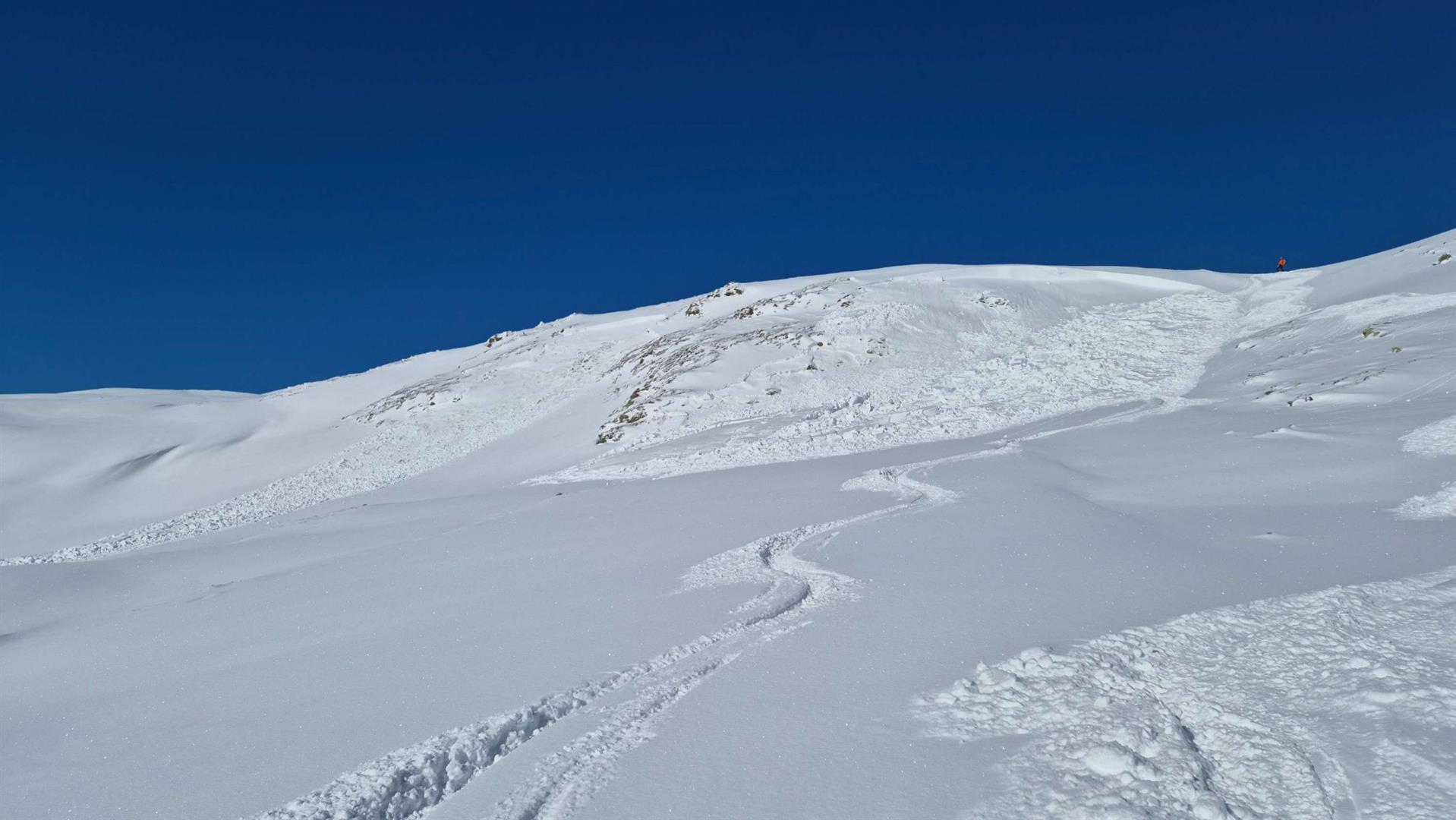
In western regions where precipitation was heaviest, there were also successful artificial triggerings.

Gesprengte Schneebrettlawinen mit Anrissmächtigkeiten um 1,5m an der Grenze zu Vorarlberg (© Marvin Kärle, 11.01.2026)
Artificially triggered slab avalanches with explosives, fractures 1.5 metres deep, on the Vorarlberg border (© Marvin Kärle, 11.01.2026)
Spontaner Lawinenabgang im Fimbatal Richtung Heidelberger Hütte. (Man erkennt eine Staubwolke im Hintergrund) (© Christian Riepl, 10.01.2026)
Naturally triggered avalanche in Fimbatal view towards Heidelberger Hütte. (A snow plume is visible in background.) (© Christian Riepl, 10.01.2026)

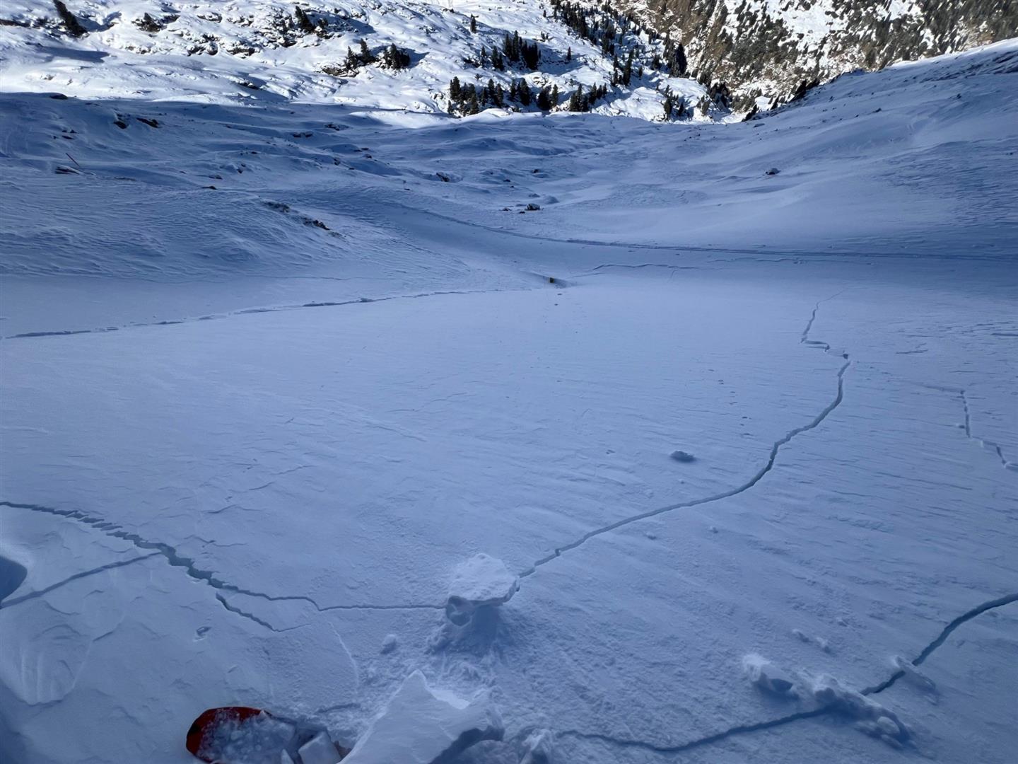
Fractures and settling noises

There were also numerous reports of fractures and often highly marked settling noises. These are extremely serious alarm signals. In most cases, avalanches did not release for the simple reason that the terrain was too flat for a slab avalanche to trigger. Some fractures and settling noises were doubtless caused by remote triggering.
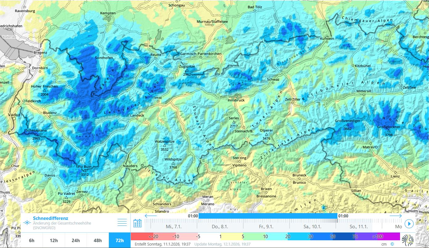
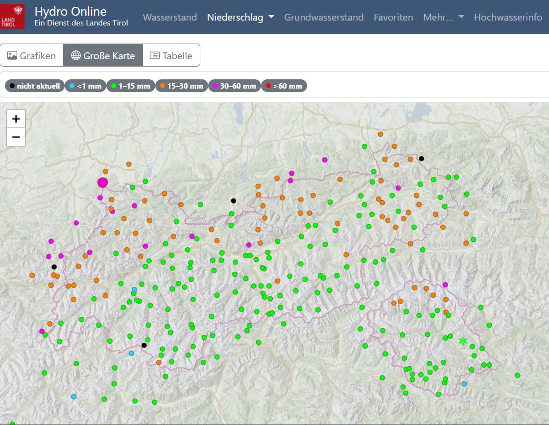
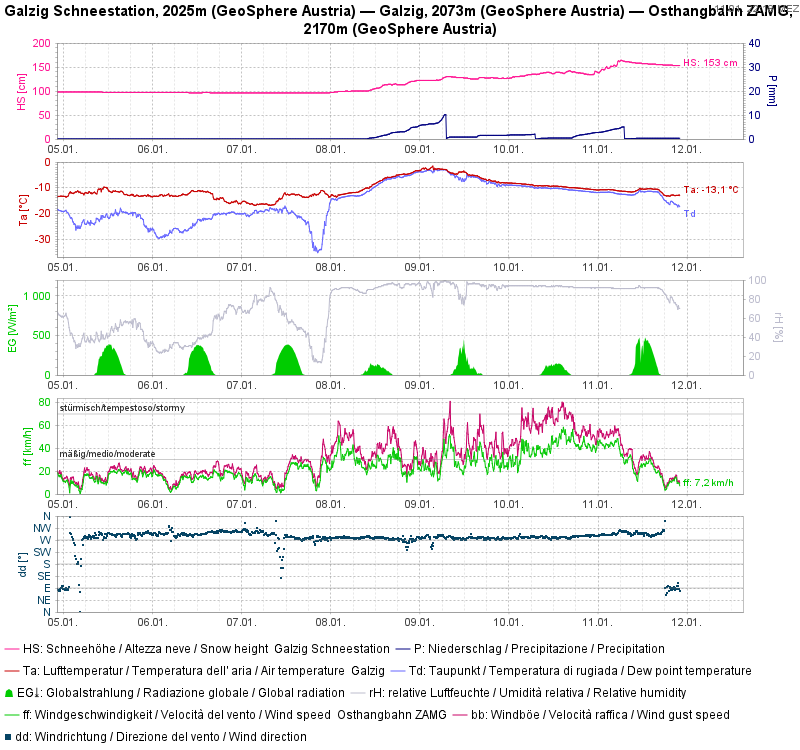
Man erkennt bei dem im Variantenbereich des Skigebietes See im Paznauntal aufgenommenen Fotos sowohl Rissbildungen und eine fernausgelöste Schneebrettlawine. (© Daniel Kleinlercher, 11.01.2026)
Fractures and a remotely triggered slab avalanche are both visible in this photo taken in the free-riding zone of the ski area See im Paznauntal. (© Daniel Kleinlercher, 11.01.2026)
Rissbildungen im Rotmoostal in der Gurgler Gruppe (© Hugo Reindl, 11.01.2026)
Fractures in the Rotmoostal valley in the Gurgler Massif (© Hugo Reindl, 11.01.2026)
Rissbildung in der Grieskogelgruppe (© Lukas Ruetz, 11.01.2026)
Fracture in Grieskogel Massif (© Lukas Ruetz, 11.01.2026)

Weather analysis

Let’s cast a glance at a few different maps and weather station graphs. That way, a coherent picture results which fits into the forecasts.

72h Schneedifferenz für Tirol: Der Niederschlagsschwerpunkt lag im Westen, Norden und Nordosten.
72-hr snow depth differences in Tirol: the focus of precipitation lay in western, northern and northeastern regions.
72h-Niederschlagsdifferenz via der Daten des Hydrographischen Dienstes (Hydro Online)
72-hr differences in precipitation via data from the Hydrographic Service (Hydro Online)
Wetterstationsgrafik Galzig: Erster Niederschlag (Schneefall) während einer Warmfront, dann folgten weitere Niederschläge bei wieder sinkenden Temperaturen. Starker bis stürmischer Wind. Dann Wetterbesserung.
Galzig weather station graph: initial precipitation (snowfall) during the warm front, more precipitation subsequently followed with temperatures dropping further. Strong-to-storm strength winds. Followed by weather improvement.
Wetterstationsgrafik Sonntagsköpfl im Nahbereich des tödlichen Lawinenunfalls Wetterkreuz - Gilfert. Es wird kaum Niederschlag angezeigt. Starker bis stürmischer Wind.
As a comparison, Sonntagsköpfl weather station graph, near the scene of the fatal avalanche incident Wetterkreuz – Gilfert. Precipitation in this location is not recognizable, it was minor. Gusts of strong-velocity westerly winds

What’s coming?

On Monday, 12.01, according to Geosphere Austria, a warm front will bring us a measurable rise in mountain temperatures as a result of intensifying westerly winds, particularly on the northern flank of the Alps. In the morning hours, precipitation will set in, the snowfall level ascending to about 1500m. Moderate to brisk westerly winds. On Tuesday, further weather improvement.

For the snowpack this weather means: initially no improvement. Through the rising temperatures during the course of the day and the ascending snowfall level, there is a tendency that an even more marked slab will be able to form. The distinctly weak layers inside the snowpack will persist, in other words.

The fact remains that the highly prone-to-triggering snowpack will persist to start with. On south-facing slopes where the ground was bare of snow prior to the snowfall, the situation will be far more favorable, as long as the snow cover is deep enough so that “sharks” present no danger.

An additional important fact is that we continue to have below-average snow cover in far-reaching parts of Tirol.