Last winter (in bullet points)
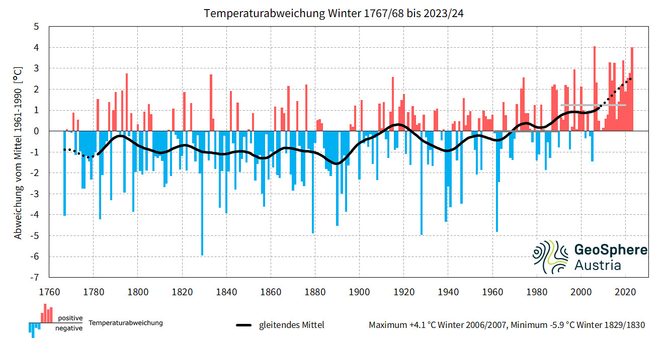
- In Tirol’s valleys, the warmest winter in 257 years of measurement history, in the mountains second warmest.
- 3-parts of winter: initially lots of precipitation in the north, dry in East Tirol; after Christmas a lengthy warm period, not much precipitation. As of mid-February, repeated southern barrier cloud situation.
- Frequent rainfall up to high altitudes, including in deep winter (> 2500 m)
- Little snowfall at low altitudes, average snow depths in the mountains.
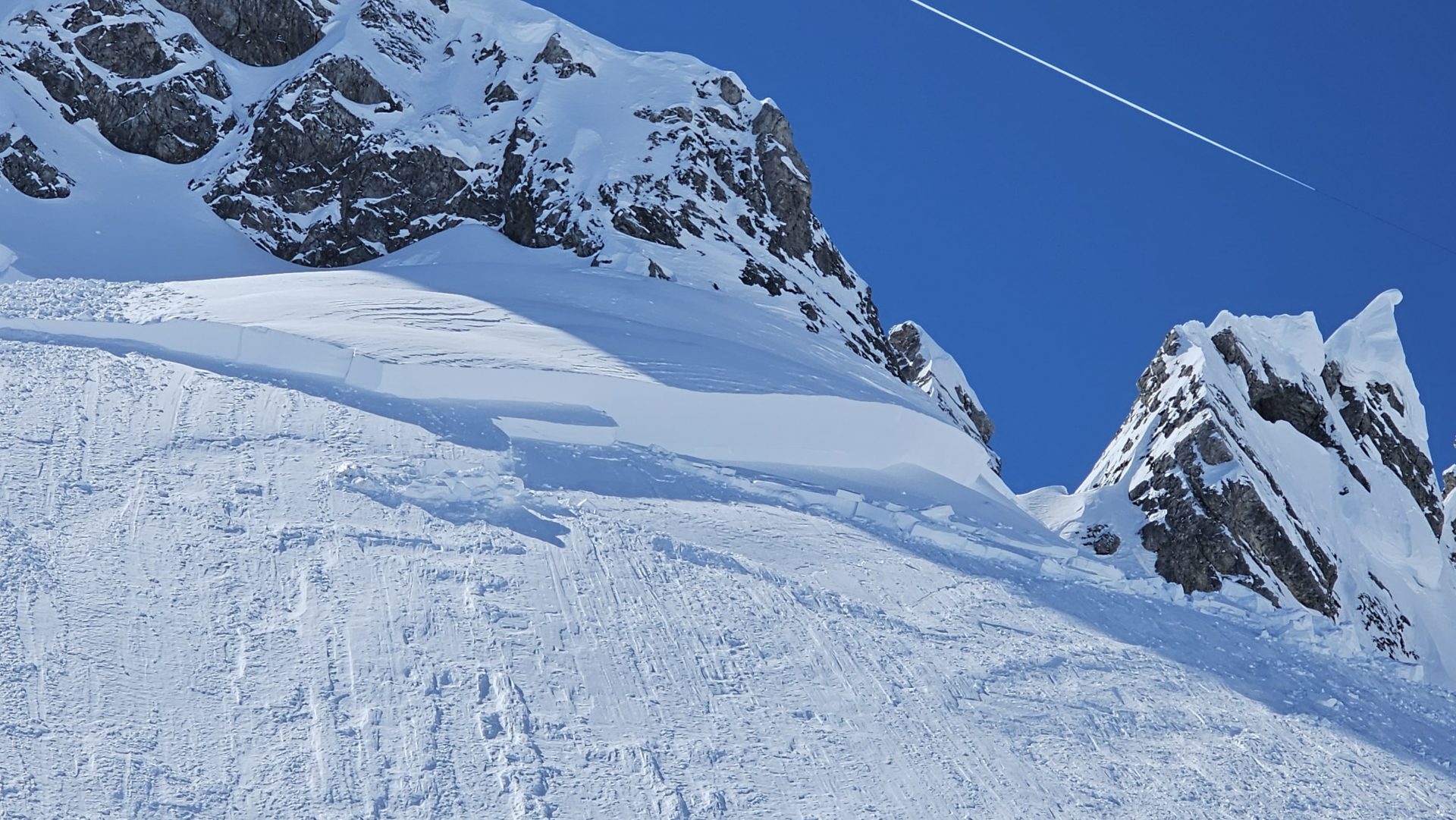
- Gliding snow is an ongoing condition
- By far warmest February in history of measurement-taking (+5.4 °C in Tirol) – despite an average March, this February was +1.4 °C too warm throughout Austria.
- Unusually warm air masses in early April, and thus, snowpack rapidly became thoroughly wet up to high alpine regions.
- Eight persons lost their lives in avalanches in Tirol during the 2023/24 winter season. On average there were 11 fatalities annually over the last 20 years, i.e. since winter season 2003/04.
Snapshots of winter in chronological order
Start: intensive precipitation
Above all the season’s start, i.e. November and December, had heavy precipitation. December saw the second-most December precipitation in Austria since 1851. Reutte, with 292mm of precipitation in November, even broke a historical record (278mm in 1947). The generally N/NW weather fronts distributed precipitation irregularly: North Tirol got amounts far above average, East Tirol got only average amounts. Nonetheless all of Tirol recorded +96% more precipitation in November and +106% more in December, that is to say, more than twice as much as in the average December.
These highly unusual amounts then became noticeable in the amounts of fresh snow registered: in the inneralpine regions, along and north of the Main Alpine Ridge snow depths reached a plus of 60% in November and also in December there were above average amounts. Only in the valleys of East Tirol was there -50% precipitation compared to the long-term averages in November and December.
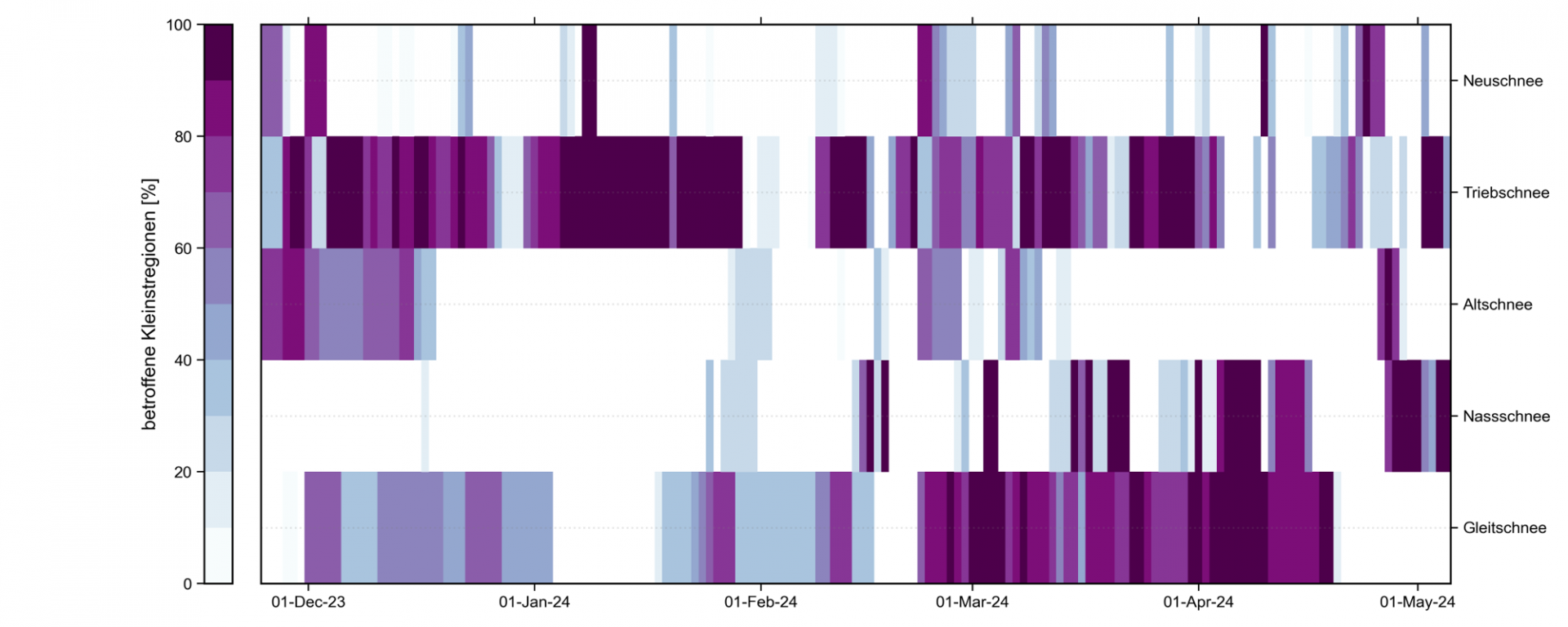
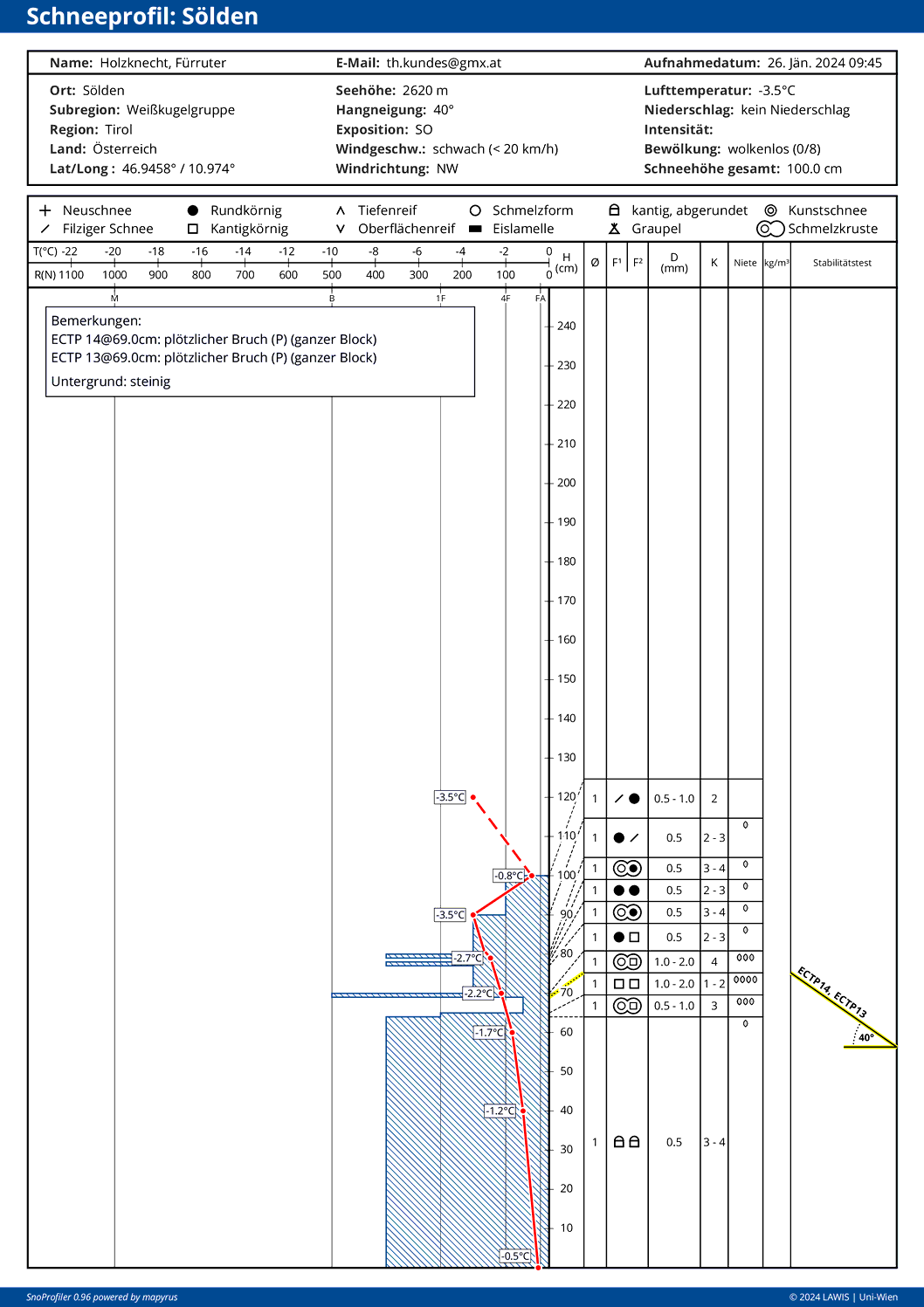
The hefty start to winter had significant effects on avalanche activity in the later season: the large amounts of snow which fell onto the warm ground raised glide-snow avalanche activity throughout the winter (see below). Enduring snowfall and the lack of an interim high pressure weather period in early winter led also to the snow at ground level being unable to form a weak layer. Such a layer can form when after the first snowfall in autumn a longer period without precipitation follows: between the warm ground and the cold snowpack surface, a stark temperature gradient forms inside the generally shallow snowpack due to outgoing radiation. If such conditions persist for long enough, expansive metamorphosis will be reinforced, forming weak layers out of faceted crystals or embedded hoar (cup-shaped crystals), which retain a certain importance for the remainder of the season. This development was fortunately lacking this winter, so we had only near-surface weak layers to deal with, and those for only brief spells.
Repeated rainfall up to the heights
The unusually mild temperatures caused rainfall up to high altitudes (>2000m) much more often, instead of snowfall. Thus, in every winter month there was liquid precipitation falling at altitudes higher than 2500m. As we know, rain leads to a higher loss of firmness in the snowpack, depending on snow temperature and rainfall intensity. Rainfall up to high altitudes also demands assigning Danger Level 4 – “cold on warm.” If due to rainfall a moistened snowpack is blanketed by cold snowfall, since in its wake a persistent weak layer of expansively metamorphosed crystals constituting a weak layer can form, something not unusual near melt-freeze crusts. In addition, rainfall followed by receding temperatures without precipitation causes melt-freeze crusts to form. Particularly during long enduring cold periods of fine weather, persistent weak layers also develop.
In this regard, winter season 2023/24 was perhaps a harbinger of the future: due to warmth during precipitation and snowfall levels above 2000m becoming ever more frequent, we must expect the formation of melt-freeze crust layers at high altitudes to an increasing degree.
“We frequently observe trigger-sensitive weak layers taking shape in the form of faceted crystals near melt-freeze crusts. If in future it continues to rain ever more frequently at high altitudes this process can be amplified.” Patrick Nairz
Warm period as of Xmas holidays
The latter part of December was mild, ending on 24 December with a warm front (one of the precipitation bouts bringing rainfall up to at least 2600m). In intensity, the Christmas thaw gave honour to its name: at low altitudes a large part of the snowpack simply melted away. And thus, the new year in the valleys began without any snow on the ground and a warm period without precipitation. Yet in spite of below-average amounts of snowfall, in later January we had two brief phases of heightened avalanche activity.
Highly trigger-sensitive drifts in mid-January
The first phase of heightened avalanche activity was on the weekend of 13-14 January. On the previous weekend there had been snowfall and little wind. Conditions for surface hoar formation prevailed during the week that followed.
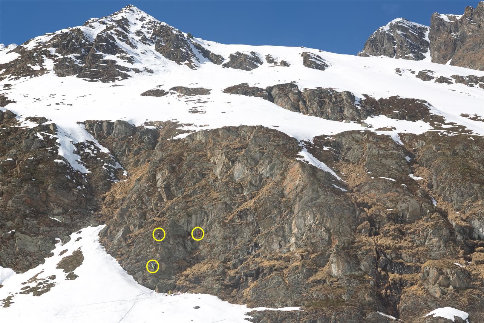
On 13-14 January, westerly winds arose, transporting the loosely-packed fresh-fallen snow. Generally small-sized but highly prone-to-triggering masses of snowdrifts were generated which came to rest atop surface hoar or on top of the still loosely-packed fresh fallen snow. Subsequently, numerous reports reached us that avalanches had triggered, most of them in Ausserfern and Lechtal as well as in the Tux Alps. Also the avalanche with a fatality in the fatal incident on Geierköpfen in the Ammertal Alps was a result of this situation.
“Loosely-packed cold snow on the snowpack surface and intensifying westerly winds were the ingredients for freshly generated, usually small-sized snowdrift accumulations on 13-14 January. These were easily triggered and led to numerous avalanches.” Norbert Lanzanasto
Near-surface persistent weak layer problem briefly on sunny slopes
The second phase of heightened avalanche activity and, as a result, a bevy of observer reports coming into headquarters about avalanches triggered by persons, were the triggerings deriving from a near-surface persistent weak layer that formed starting on 9th January: solar radiation on often cloudless days led to the still loose fresh snow just beneath the snowpack surface becoming moist. Subsequently, melt-freeze crusts (so-called “radiation crusts”) formed corresponding to Danger Pattern 4 (“cold on warm” – a weak layer of faceted crystals). Lacking solar radiation, a radiation crust and the resultant weak layer would not have been able to form on shady slopes by itself. Fresh snow and freshly generated snowdrifts blanketed the trigger-sensitive weak layer after the snowfall on 25-27 January, thus forming the requisite slab for the slab avalanches. The avalanche incidents connected with this persistent weak layer occurred particularly on steep east-facing and south-facing slopes above 2600m and were limited to areas north of the Main Alpine Ridge. Especially the Stubai and Otztal Alps were struck. This situation also led to the fatal avalanche incident on Gaiskogel in the Kühtai-Geigenkamm region.
Following the brief period of heightened proneness to triggering on the weekend referred to above, the weak layer consolidated due to solar radiation and warmer temperatures which immediately followed. This was because the flat temperature gradients near the weak layer stoked up the process of expansive metamorphosis of the crystals. Faceted crystals became rounded, reinforced bonding of single crystals was the result, which in turn raised the firmness of the weak layer still further.
Subsequently, no further avalanches occurred which were connected to the weak layer just discussed. Results of stability tests corroborated the decrease of proneness to triggering.
Firn snow in deep winter
Whereas January was merely warm, February broke all records: Tirol recorded temperature divergency from long-term averages of +5.4%°C. It was by far the warmest February in more than 250 years of measurement-taking history.
The repeated bouts of far-too-mild temperatures led to good firn snow conditions in the midst of deep winter. An initial period where the snowpack surface was capable of bearing loads, particularly at intermediate altitudes, occurred following the Christmas thaw referred to above and came to an end with the precipitation at New Year. The second, much longer period began at the end of January and was limited mostly to intermediate altitudes. Until 7 February, mild, dry and sunny conditions prevailed which on south-facing slopes provided good firn-snow conditions.
And yet, snowfall for East Tirol
In January and February, North Tirol had average precipitation, slightly below the norm, and the weather at intermediate altitudes brought a striking decrease in the snow cover. However, above the treeline there were still reserves from early winter. In East Tirol, on the other hand, the start of winter was delayed noticeably. The catch-up began quickly starting with the precipitation launched on 8 February. From the start of February until mid-April, southern barrier-cloud fronts dominated widespread. Thus, In February in East Tirol there was almost twice the precipitation as average. Also the regions along the Main Alpine Ridge received hefty amounts of snowfall. Obertilliach recorded 116mm of precipitation in March, a plus of 97% compared to the long-term average from 1991-2020. The temperatures in Tirol were on average 2.8°C too warm, but the highly diverse snowpack persisted by and large through March, depending on altitude. Whereas in Lienz there was not one day in March with snow on the ground (usually there is snow in Lienz on 8 days in March), more precipitation followed later. In the end, the maximum snow depths above 1500m in Tirol lay at 10 to 20% above average.
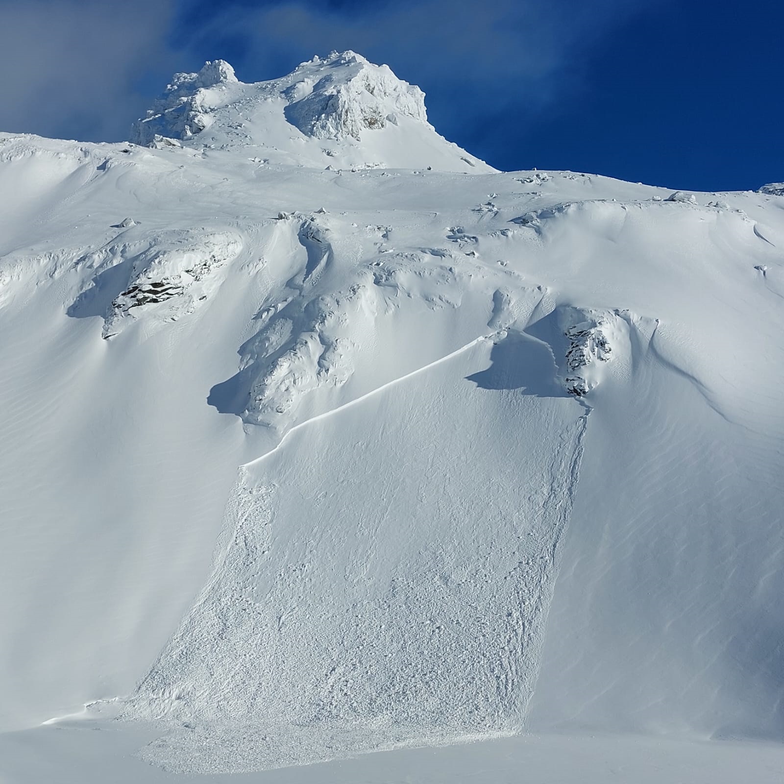
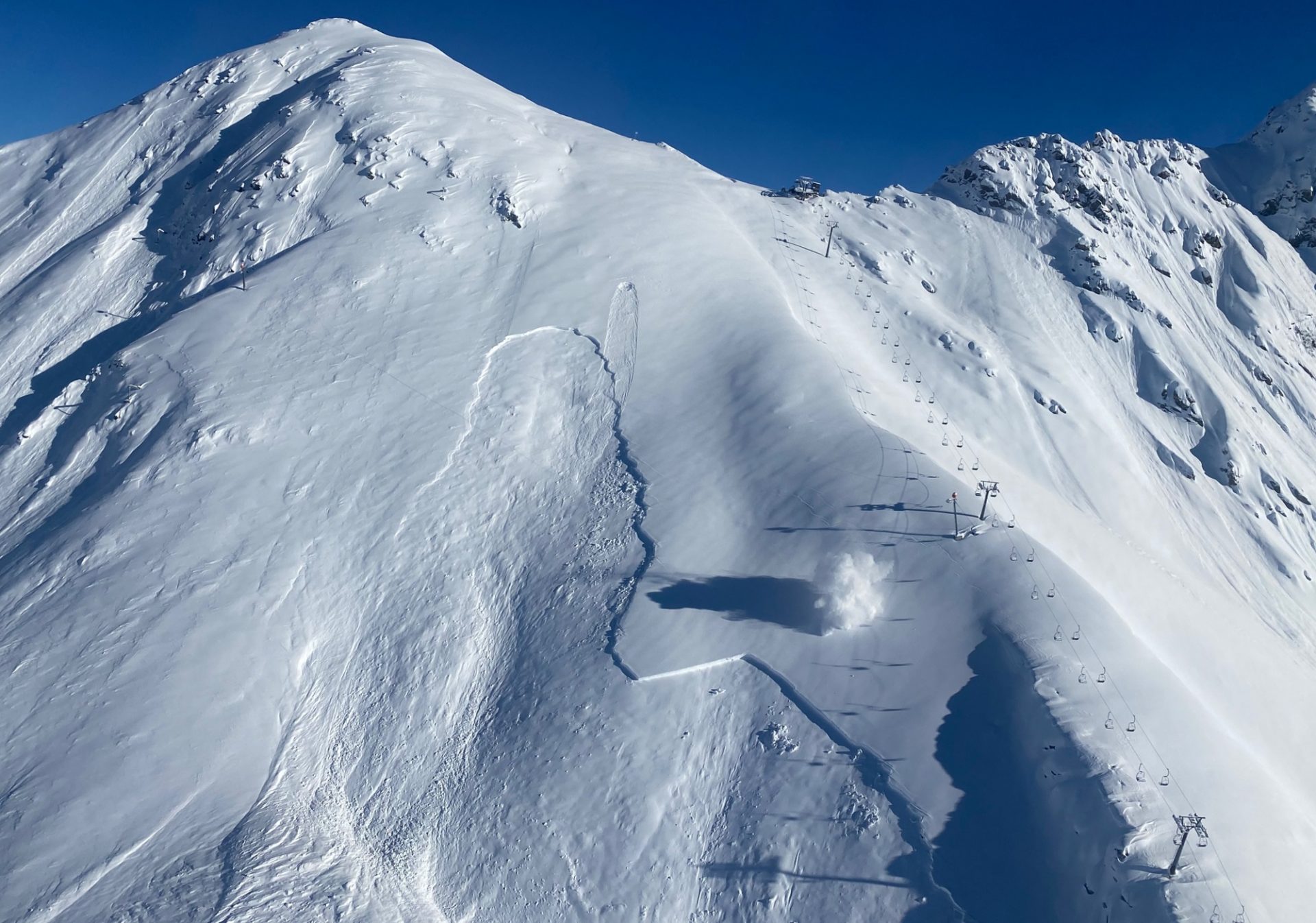
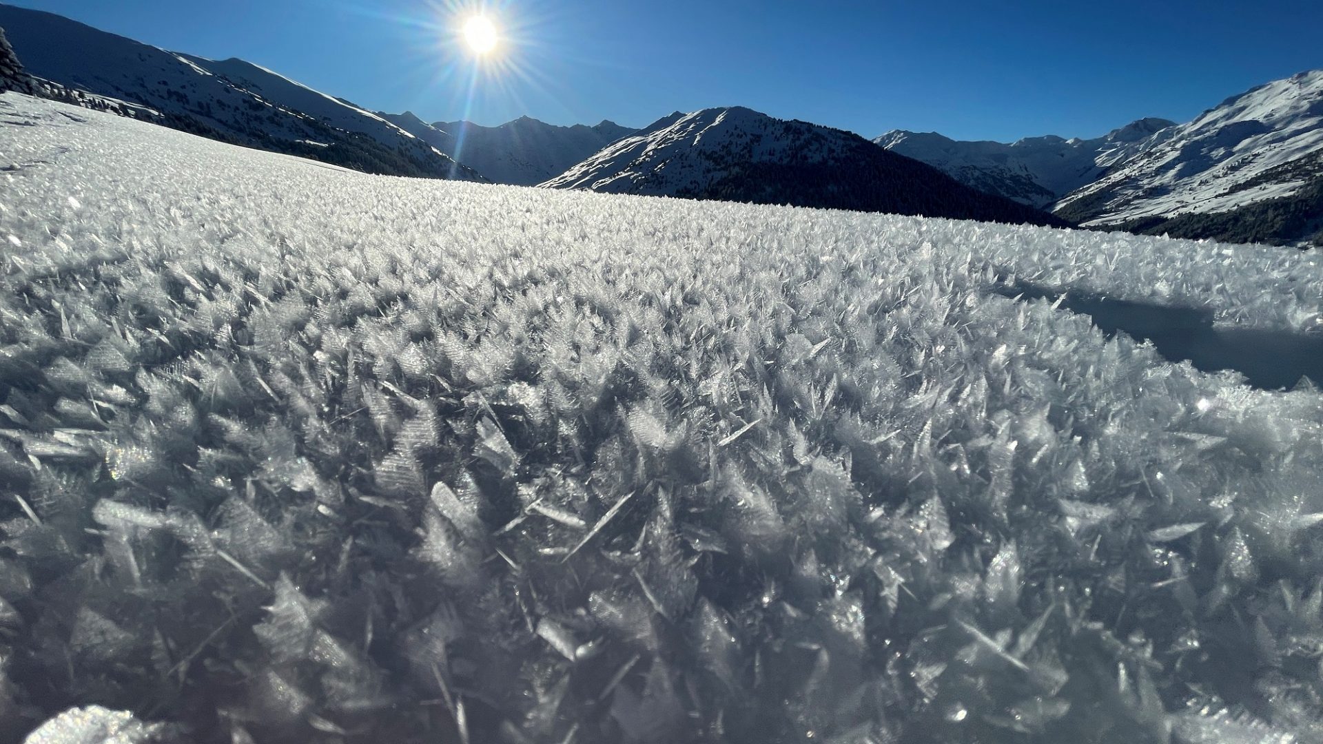
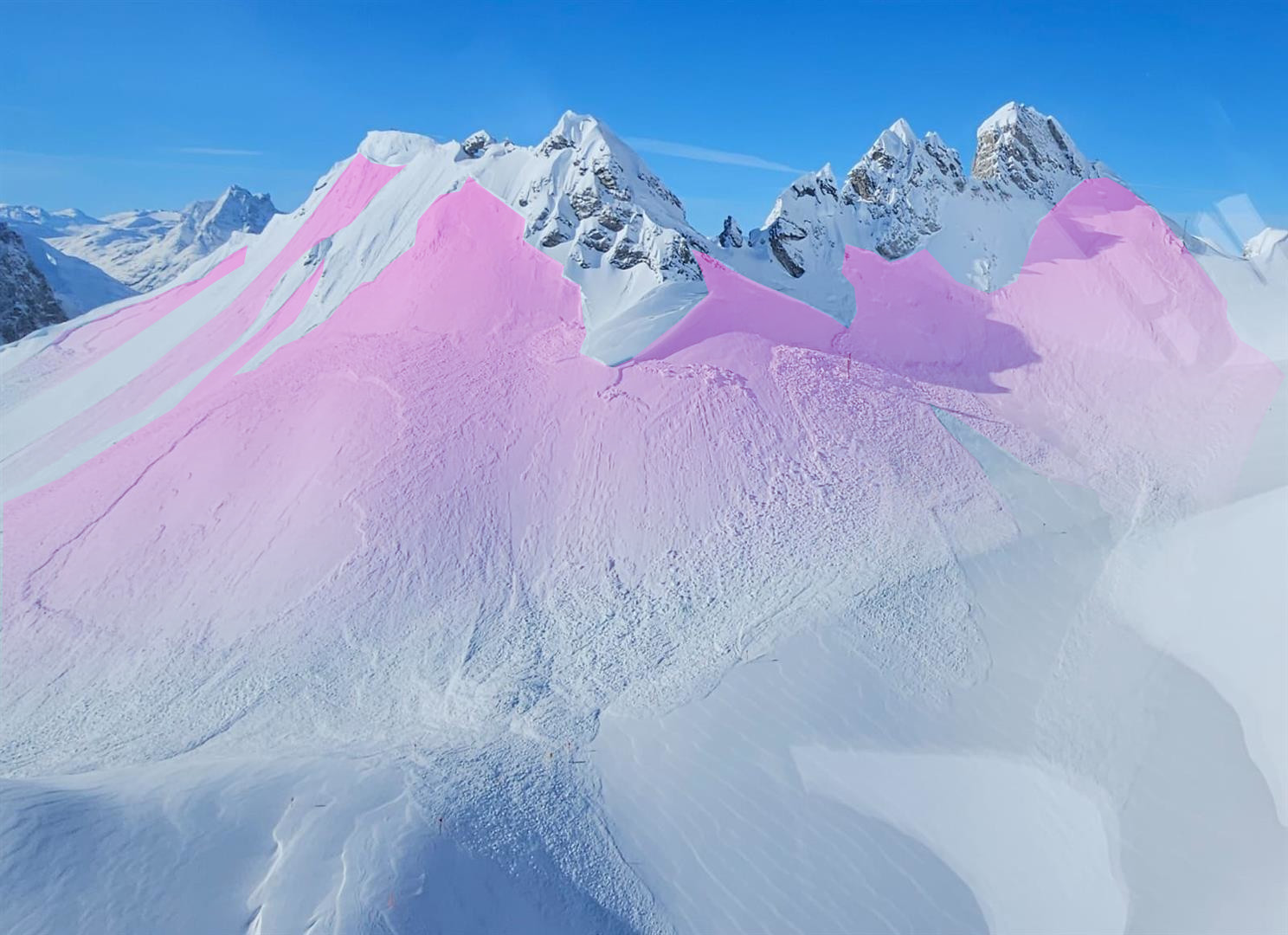
Graupel as relevant weak layer in March
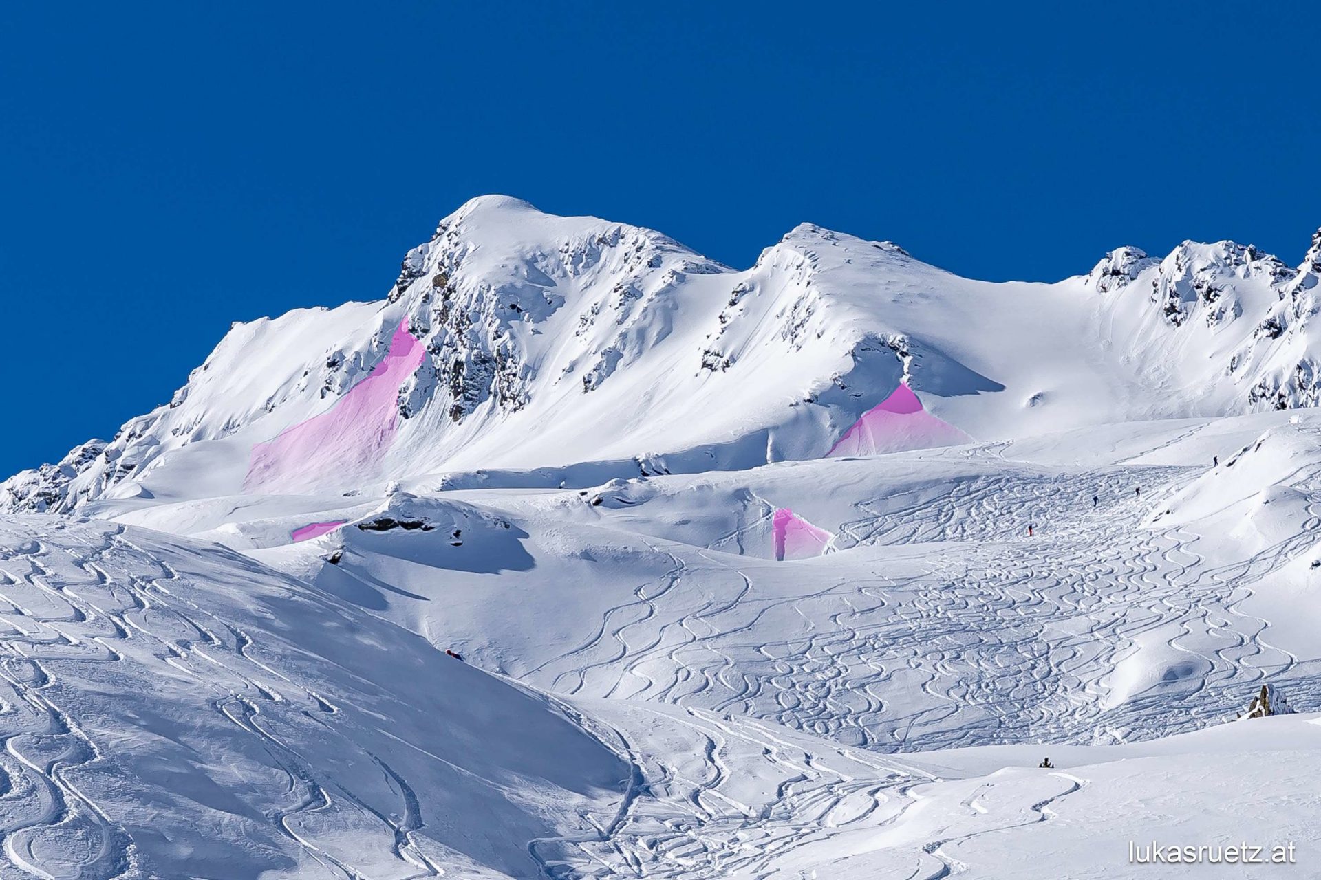
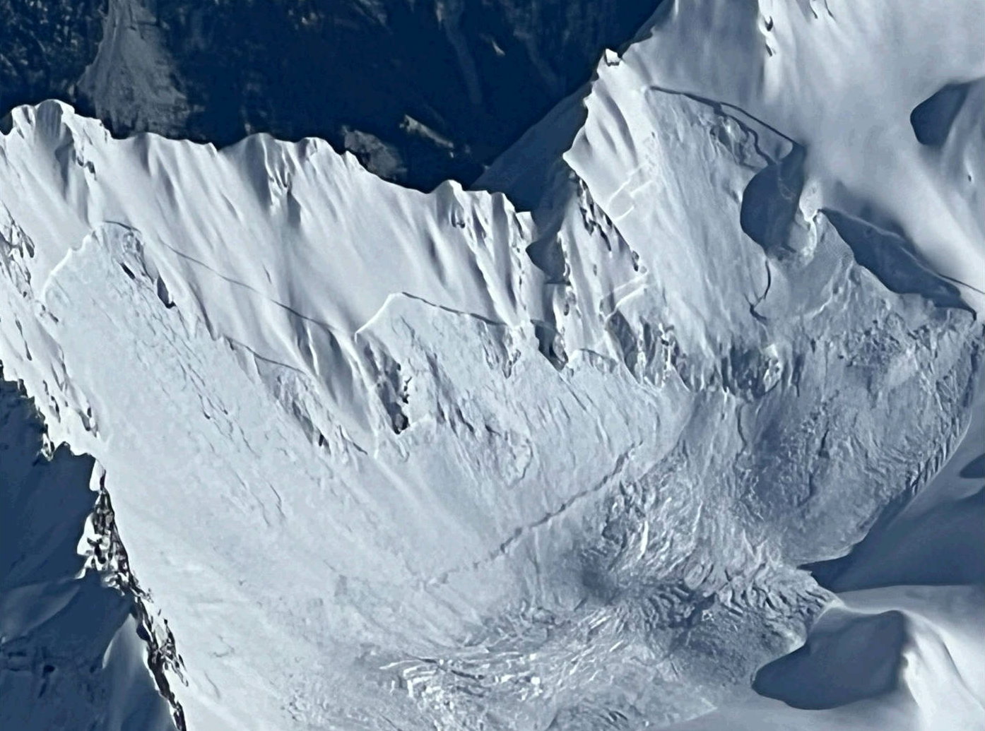
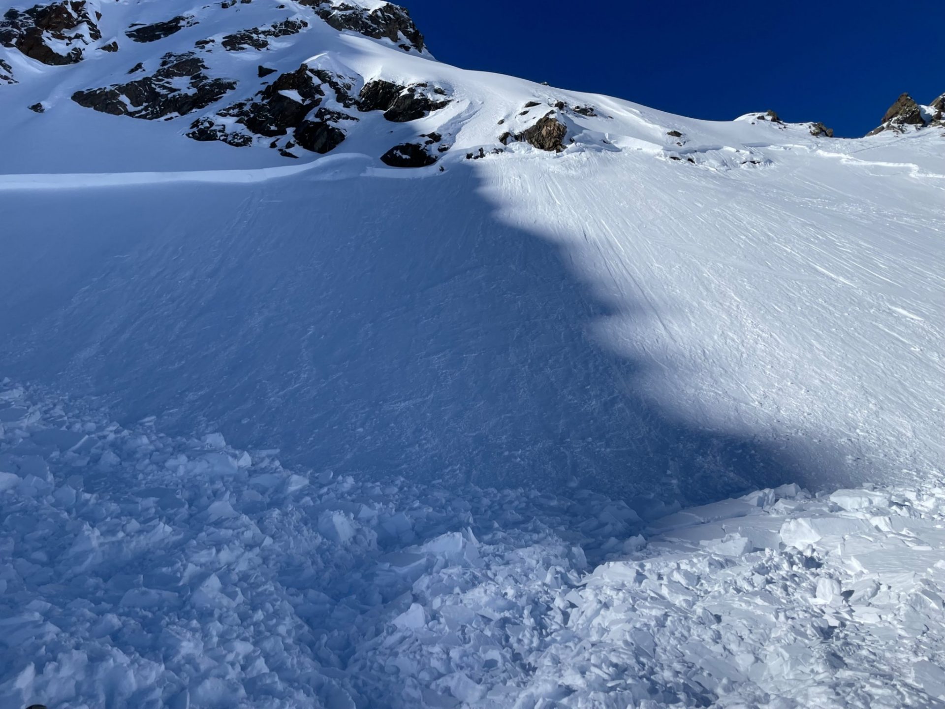
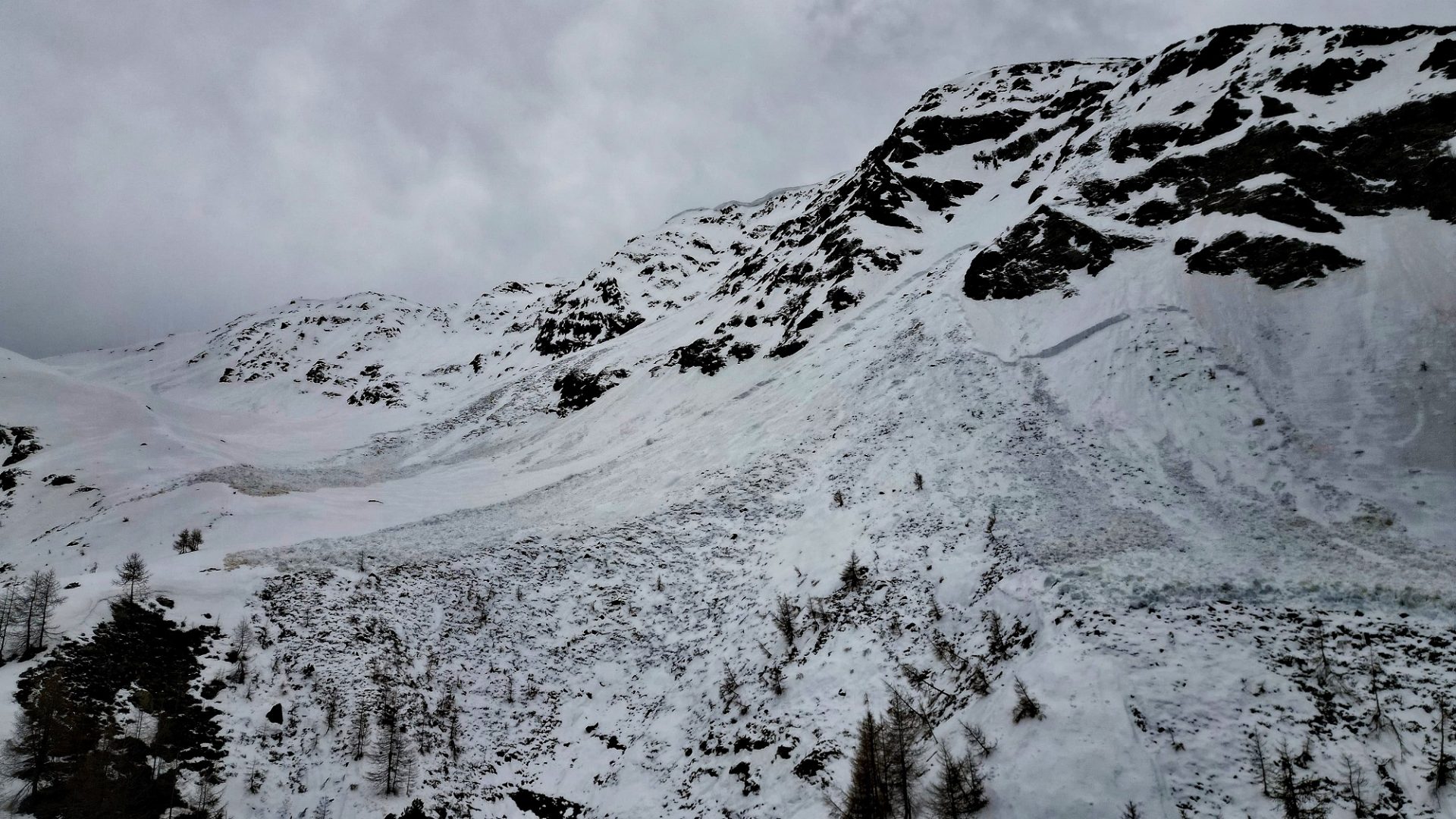
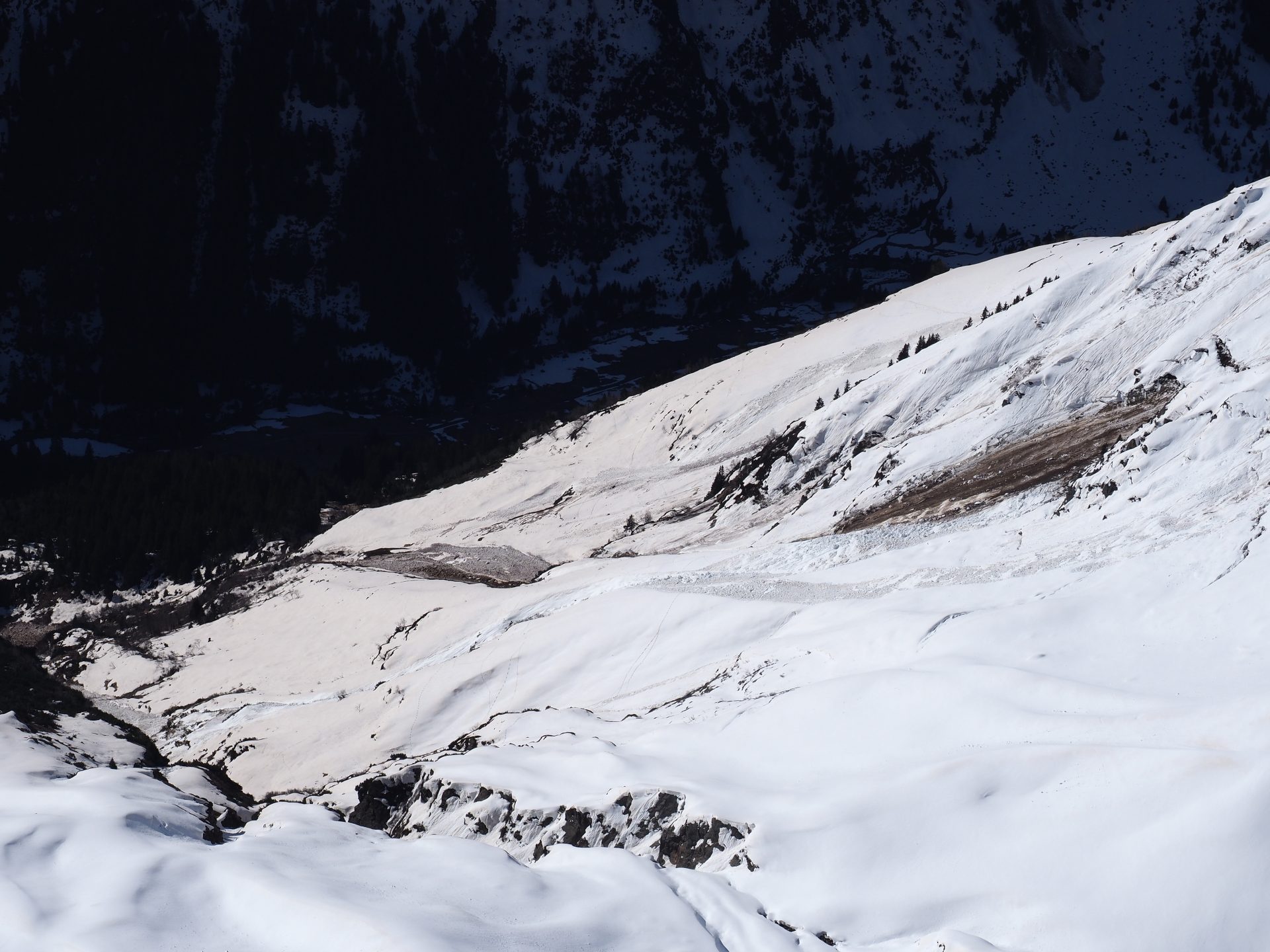
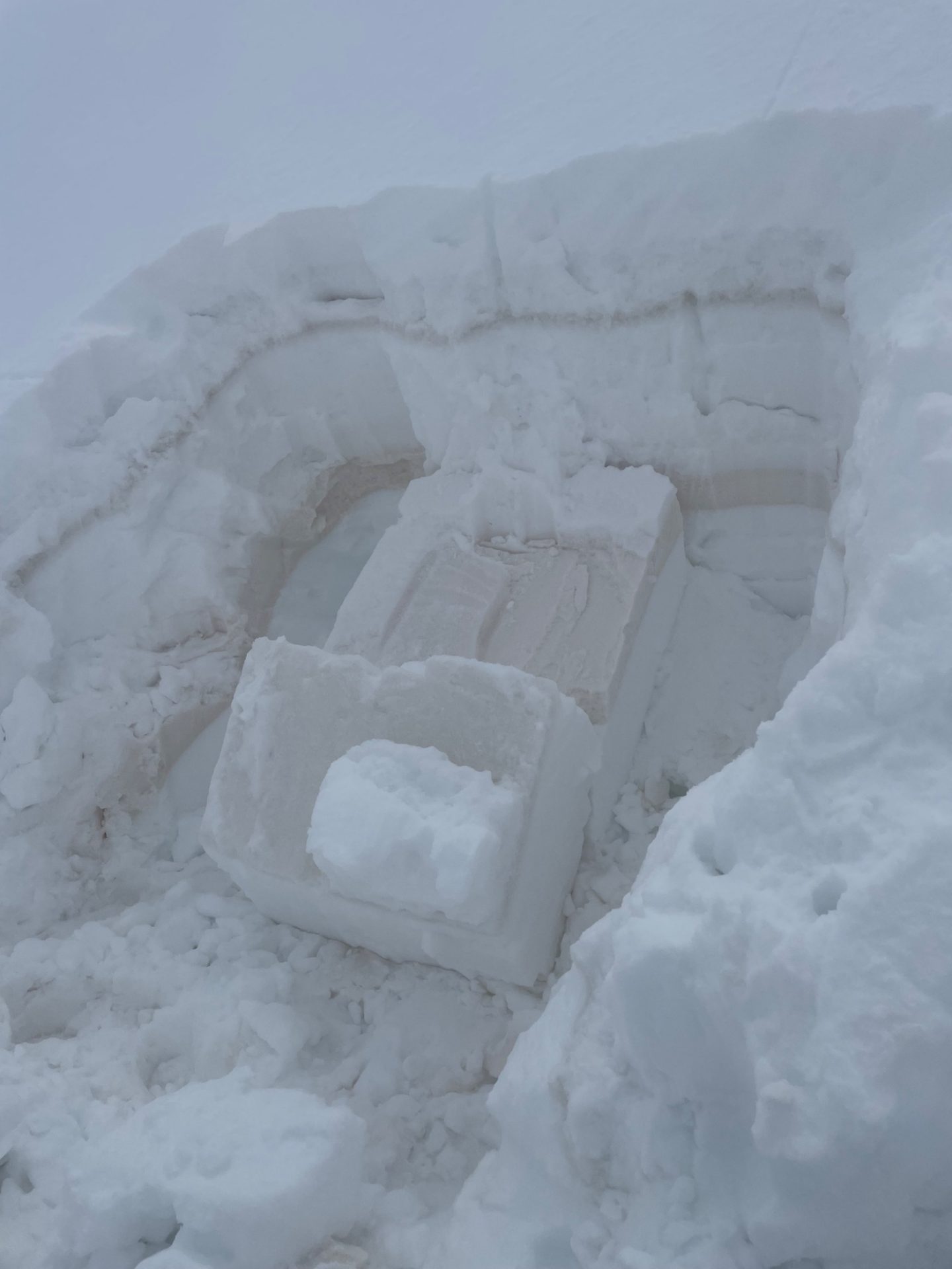
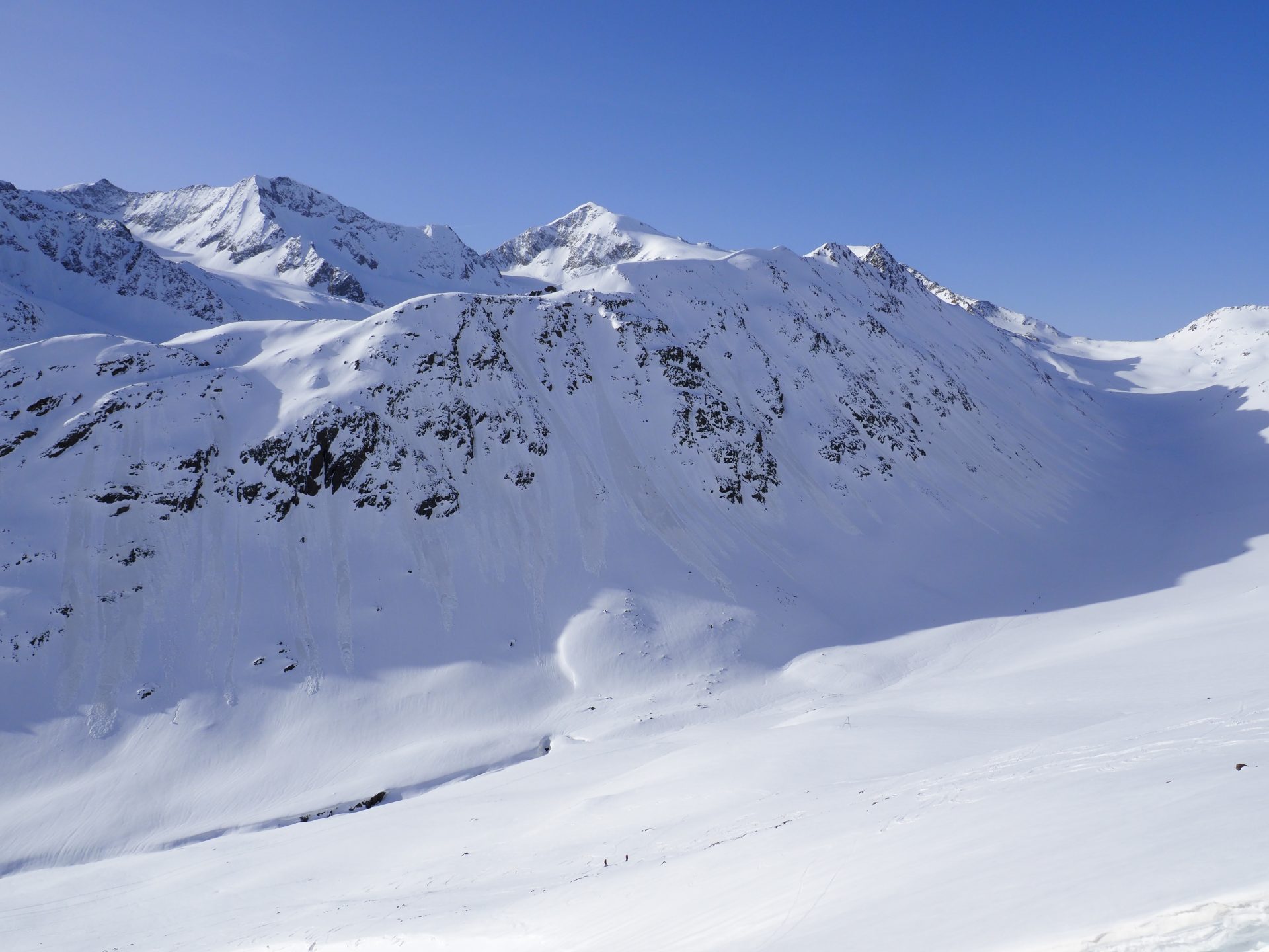
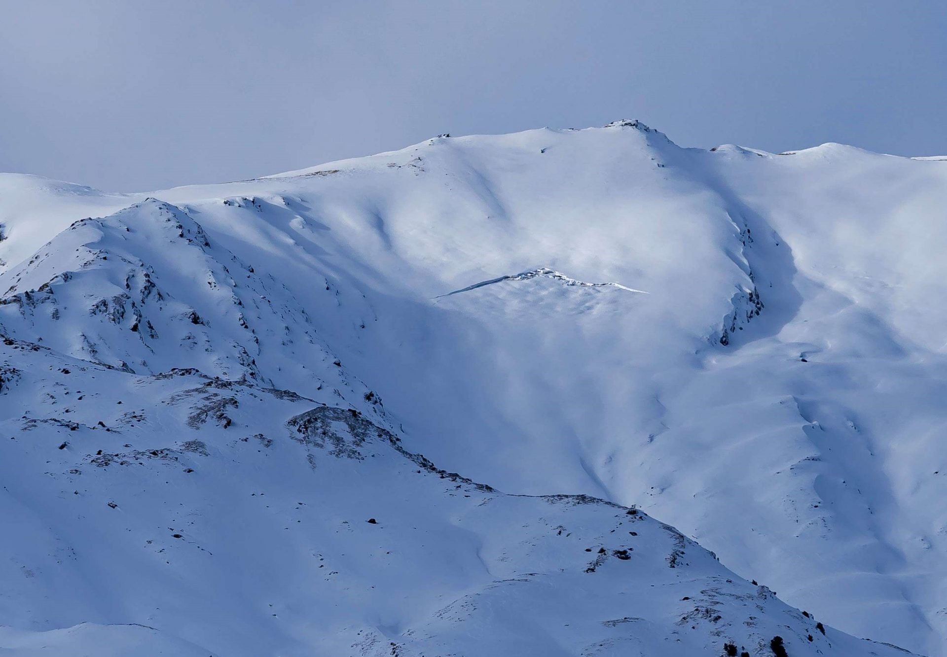
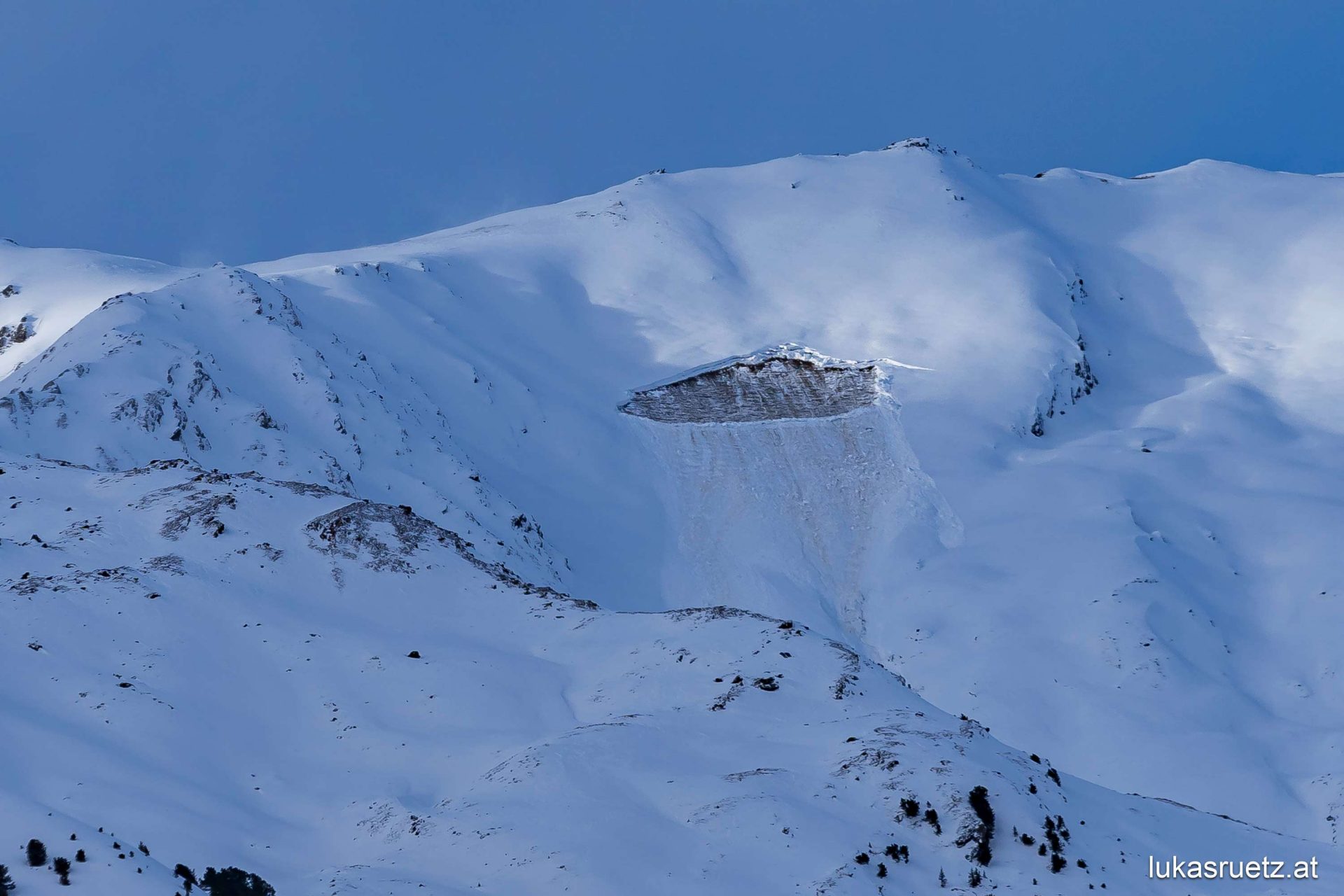
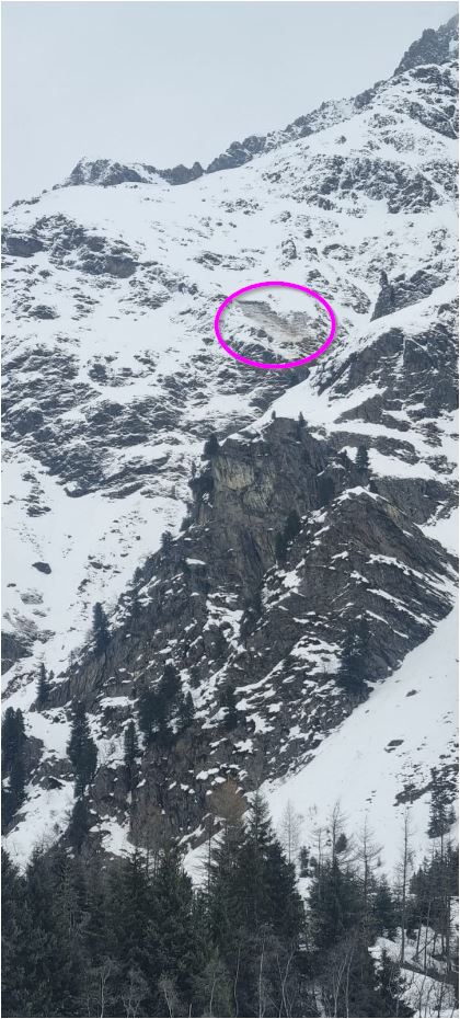
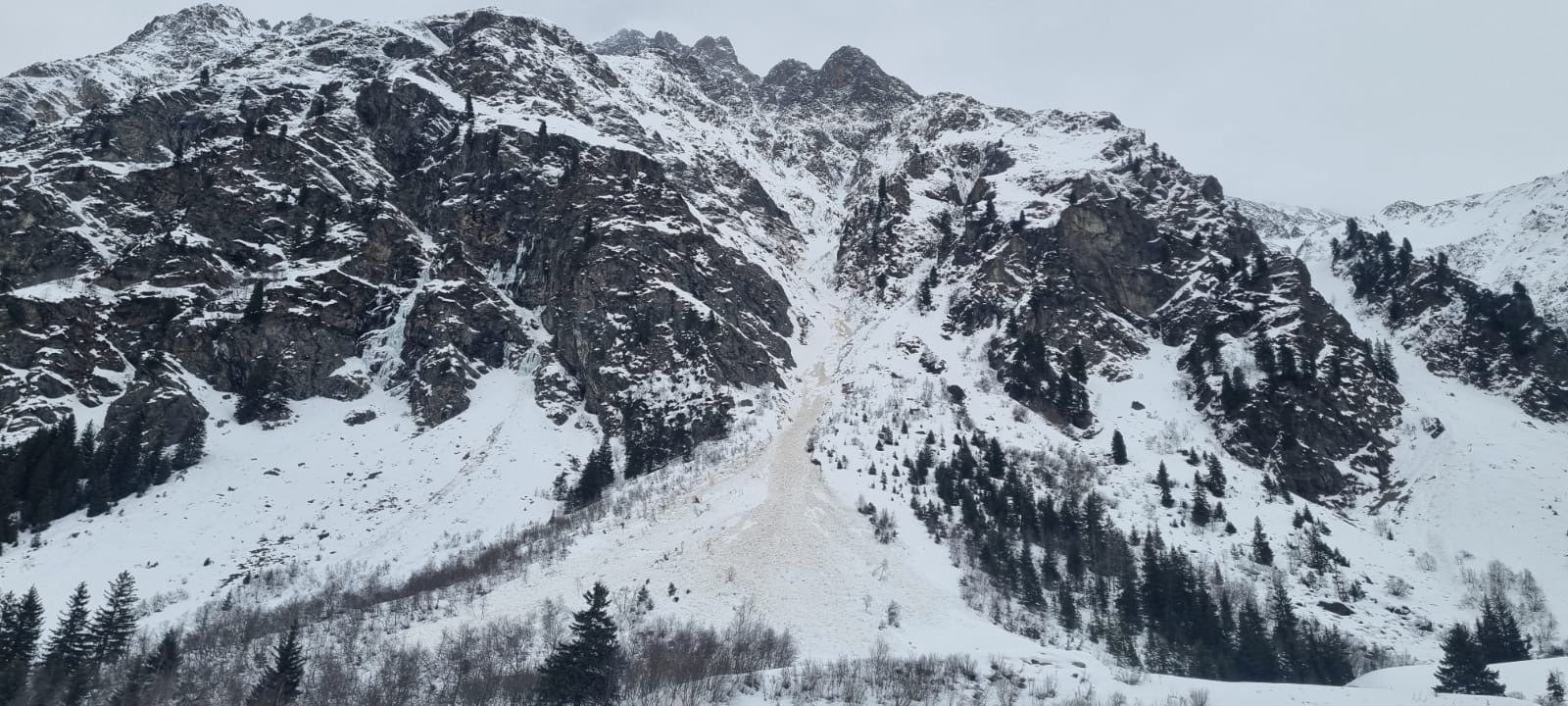
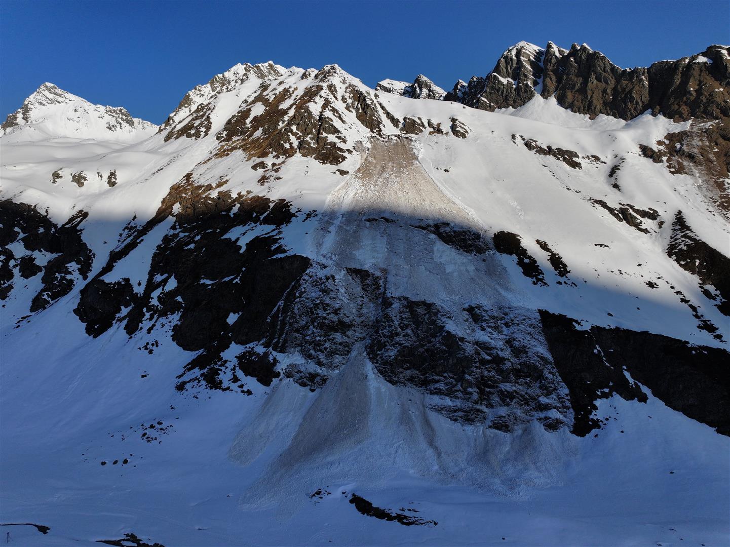
Starting at the beginning of March, spring became palpable: showerlike, convective precipitation brought intensive waves of graupel. Deposited graupel granules constituted a relevant weak layer for slab avalanches, even though only for brief spells, nonetheless repeatedly. Avalanches seldom trigger in graupel but are observed nevertheless. At the end of March, graupel was responsible for two surprising large avalanche releases, at least in the initial triggering phase (see photos). The combination of weak layer and slab resulted in the course of a marked cold front which arrived with thunderstorm-like precipitation on 23 March (incl. graupel as a weak layer) along with storm-strength winds (forming a slab).
Graupel is typical of late winter and springtime in particular. The sun delivers noticeably more energy than in winter; this, in turn, heats up the ground and permits air masses to rise. These convective processes are always turbulent and and lead to ice crystals flowing through the clouds which form; these then drop somewhat in altitude and are thrust skywards again, several times, before they ultimately fall to the ground. Inside one cloud, there also exist water droplets, apart from the graupel granules; these drops remain liquid until far below freezing temperatures and are thus called cold drops. When such cold drops bump into ice crystals they immediately freeze. Such collisions occur quite frequently in a turbulent whirlpool of motion, thus forming graupel: an ice crystal frozen to cold water drops. Graupel granules are round, pale white in colour, can be up to 5mm large and resemble styropor balls in appearance.
“In convective shower clouds or thunderclouds, strong winds ascend and descend. Cold water droplets collide with flying ice crystals in this scenario. If this goes on long enough, typically round, white graupel granules form.” Marie Hofmann, apprentice at LWD Tirol
April heat wave, marked cycle of wet snow
April brought record-breaking temperatures. The weather station at the University of Innsbruck registered 30.7°C on 14 April – the highest temperature ever measured there on an April day since the beginning of measurement-taking in 1877. The extraordinarily warm air masses reached Tirol in two stages via a SW air current, creating a snowpack which was increasingly wet to wintery, at least at high altitudes. These two early summer periods were brought to an end by a cold front passing through. In both cases the cold fronts were connected with heightened wet-snow and avalanche activity, even though brought about by differing causes:
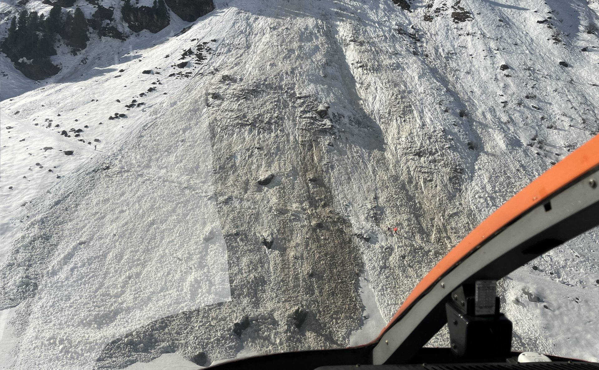
In the first case the fresh fallen snow on the day after the cold front passed through, 11 April, was moistened by strong solar radiation and mild temperatures. The loosely-packed fresh snow lost firmness for a spell and the result was high activity of loose-snow avalanches. Generally, the loosely-packed snow masses glided over the melt-freeze crust which had been created between the old snow and fresh snow and remained small to medium-sized. In some cases avalanches got their fracture impulse from a melt-freeze crust in more deeply embedded layers and swept away the already wet, poorly bonded snow from the previous warm-weather period with it. This situation led in Niedertal in the Ötztal Alps to the most consequential avalanche incident of the winter season, in which a backcountry ski touring group in their ascent to the Martin-Busch Refuge was caught in a naturally triggered avalanche and three persons were killed.
In the second case, the cold front brought rainfall up to about 2800m on 15 April along with extremely moist air masses and diffuse radiation. It was one of the most active avalanche days of winter, with several large-sized, wet slab avalanches which fractured naturally, particularly on shady slopes between about 2300 and 2600m. Fortunately, no persons and property came to grief in this occurrence.
Dust from the Sahara
The persistent southern weather front in the Alps transported not only warm air masses but also whirlpools of dust from the Sahara Desert in North Africa to our latitudes. In the first phase, huge amounts of Sahara dust arrived on Easter (30 March), colouring the skies above the mountains reddish and clouding visibility. In the precipitation of 31 March the Sahara dust was separated from the air and plunked as a layer onto the snowpack surface.
This initial deposit of dust from the Sahara Desert was subsequently blanketed by snowfall until 2 April. In the season’s finale, temperatures rose again markedly at high altitudes: the weather station at Innsbruck Airport recorded 28°C on 5 April. Warmth and sunshine led to dynamic snowmelt, particularly at low and intermediate altitudes, so that the Easter Sahara dust was increasingly bared and brought to light as the snow disappeared further.
During the following precipitation on 9-10 April the Sahara dust was also washed out of the air and again deposited on the snowpack surface. In snow profiles taken on the following days, either one or two deposited layers of Sahara dust was unearthed, depending on altitude. At low altitudes the first layer was already inside the melted snow before the second layer arrived, thus it combined with it to form one thick story of dust from the desert.
Dust from the Sahara was also whisked in the skies to Tirol in the middle and at the end of February. In comparison, the amounts were far lesser at Eastertime and there was also no precipitation (which is expressly responsible for the dust being deposited on the snowpack surface).
At the end, a normal winter again
In mid-April winter came back to Tirol on the wings of a cold front. Two weeks long, the cold endured alongside variable April weather conditions including diverse northern barrier-cloud fronts amidst repeated bouts of snowfall down to low altitudes. For example in Lienz on 23 April there was 5 cm of fresh snow registered. All in all, the major areas of precipitation north of the Inn River and on the Arlberg got more than 100cm. Despite these impressive amounts of snowfall, we usually assessed avalanche danger as moderate during those days. At that juncture of the year only a small amount of diffuse radiation is necessary to settle and consolidate the snowpack, and that is usually present in the showerlike form of precipitation in phases of inclement weather. Snowdrift accumulations are thus trigger-sensitive only for a short spell after they have been generated; only a few hours later they become hardly triggerable.
Warm and humid: an exemplary future winter?
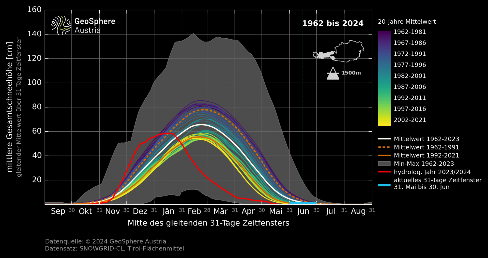
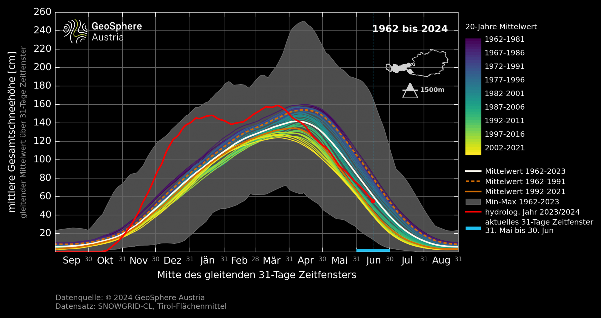
Winter 2023/24, all in all, bore the stamp of above average precipitation and very mild temperatures. This combination led to a highly diverse snow cover in the latter part of winter: depending on altitude either snowless or very little snow stood in stark contrast to the huge amounts of snow above 1500m. Between 500 and 1000m there was about 50% less fresh snow and it persisted for only half as long as in the average winter (December, January, February). At altitudes above 1500m the unusually large amounts of snow on the ground led to depths at or above the climate middle (Tirol had 44% more than average).
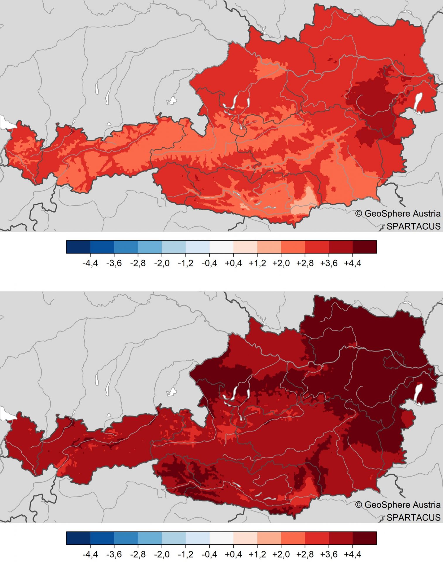
These divergencies correspond to the anticipated changes in the climate scenario for the next few decades, according to GeoSphere Austria: due to warmth, low altitudes will get more rainfall than snowfall; in addition, the snowfall will melt more rapidly than before. At high altitudes it will remain generally cold enough for snowfall. Simultaneously, increased precipitation is expected during the wintery half of the year, which could lead to above-average snow depths. Presumably, we must get accustomed to winter landscapes like those in 2023/24.
“Winter 2023/24 was emblematic of what future winters will be like: mild temperatures, so less snow on the ground at low and intermediate altitudes can be expected. Also rainfall up to over 2000m will be more frequent. However at high altitudes, above average precipitation could lead to above-average snow depths.” Christoph Mitterer
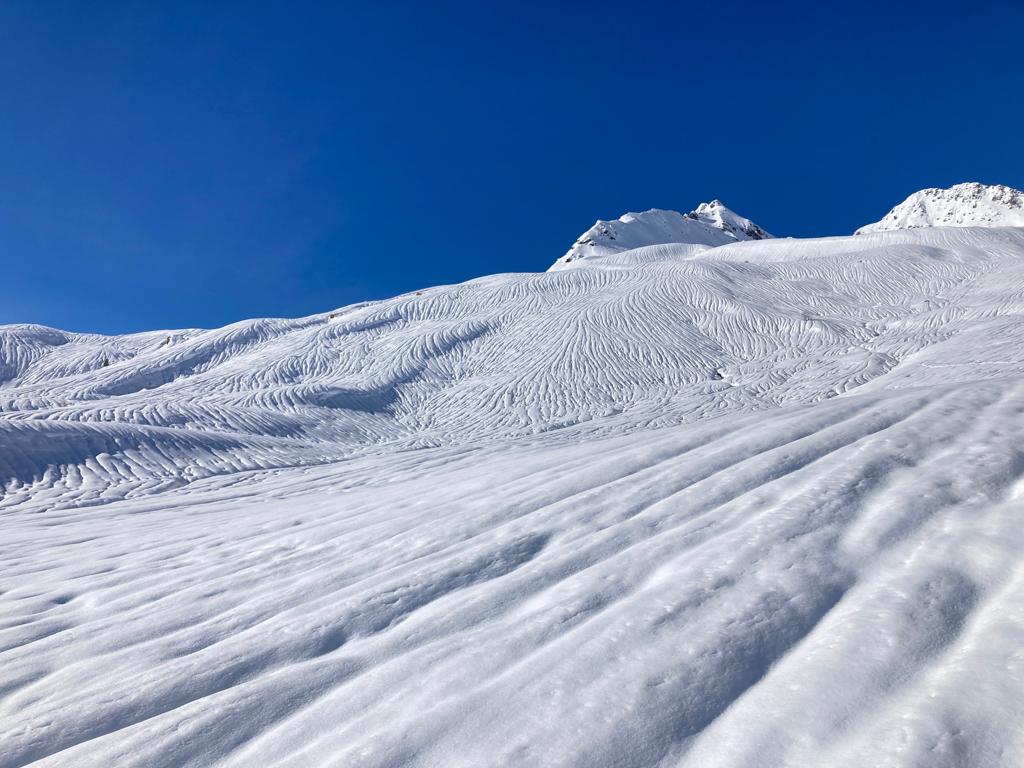
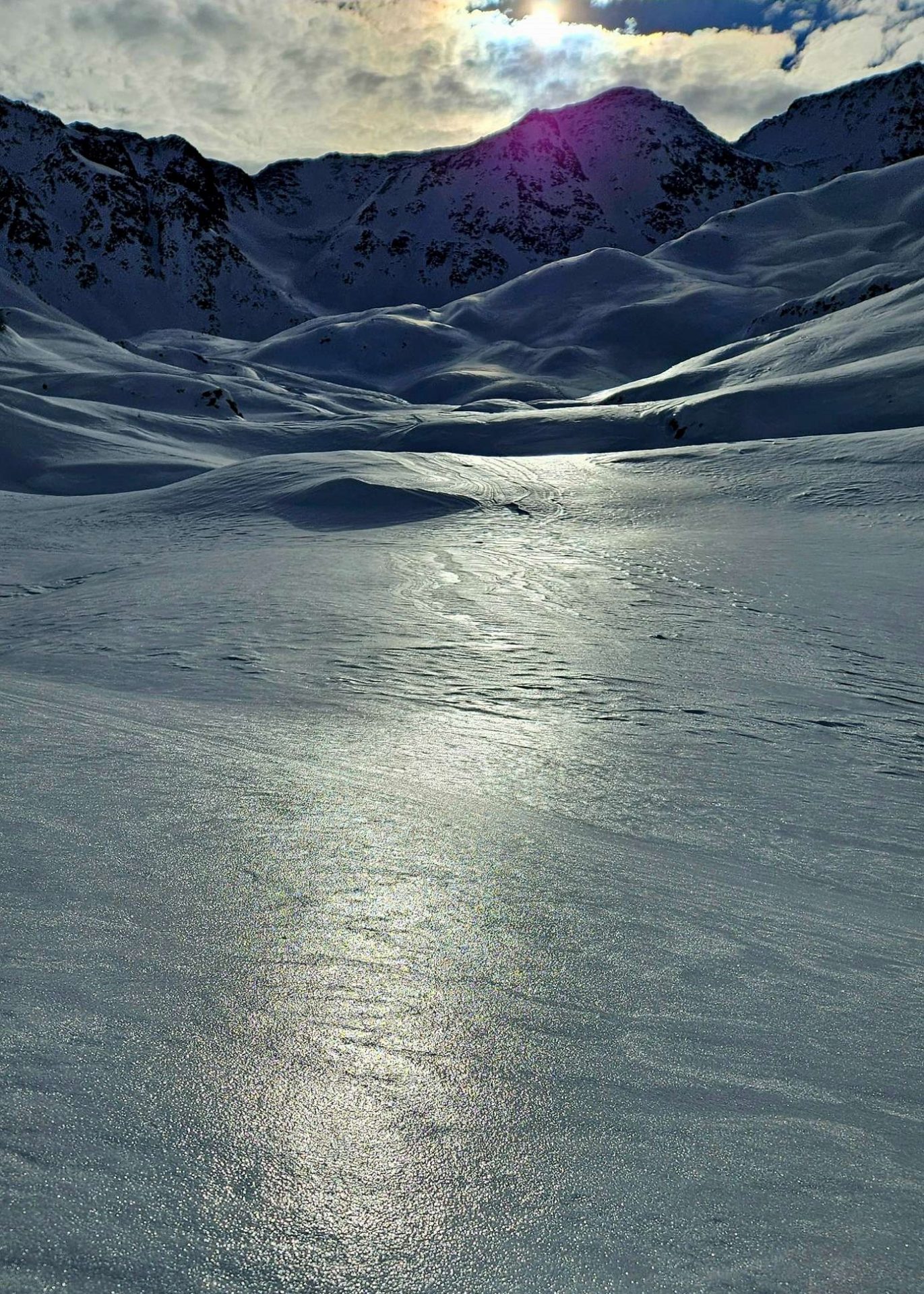
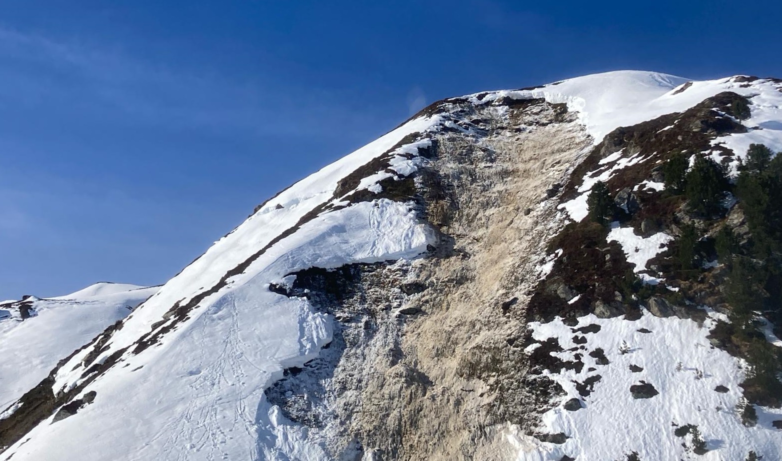
Glide-snow avalanches – winter
“Where I live it’s the most intensive early winter gliding snow I have ever experienced in the mountains. In the years 2017/18 and 2018/19 there was also increased activity, but far fewer glide cracks and fewer avalanches, as I recall.” – Lukas Ruetz, observer for LWD
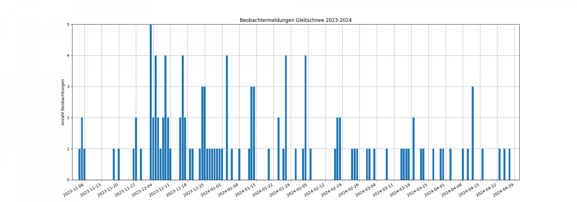
“There was no blog this winter without a photo of a glide-snow avalanche.” Thus does a blog-photo caption at the beginning of February describe the persistent gliding-snow problem in the 2023/24 season. Glide-snow avalanches were an ongoing theme throughout the winter. From each and every one of our observers it was reported that glide-snow avalanches were not only more frequent, they were also observed to have triggered where there had never been gliding snow activity before.

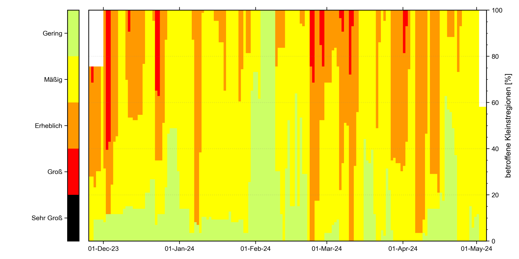
The prerequisites for such persistently high gliding-snow activity were generated at the start of winter with lots of snow falling on the warm ground (which had stored lots of heat energy in the warm, sunny autumn months). This combination is often the hallmark of an entire winter with above average gliding snow activity. This was also the case last season 2023/24: on 123 days out of 158 days (78%) on which an avalanche bulletin was published, gliding snow was mentioned as an avalanche problem at very least in the endangered regions. On the one hand, there were only two phases in that season when there was relatively little gliding snow activity (early January, mid-February). Whereas extremely high-activity gliding snow periods were evident all winter long.
The gliding snow problem was launched by heavy snowfall and also rainfall up to high altitudes in November and December. The precipitation, both solid and liquid, was a huge burden on the snowpack. These immense amounts penetrated through the snowpack down to the plants on the ground and transformed to a gliding film which diminished the frictional hold of the snow. Both of these aspects amplified the gliding process. After a certain delay, it led to heavy precipitation unleashing intense gliding snow activity.
In the latter part of winter, which was much milder, frequently variable weather conditions of diffuse radiation and high humidity, rainfall and even Sahara dust layers contributed to the snowpack becoming highly moist, thereby intensifying the gliding snow activity. In springtime, i.e. as of the point in time when the snowpack is zero-degrees isotherm, the gliding process is generally dominated by the water content of the snowpack. That is when we speak of “warm” glide-snow avalanches. The gliding snow activity during this period generally adheres to a daytime cycle and corresponds to the overall phases of wet-snow activity.
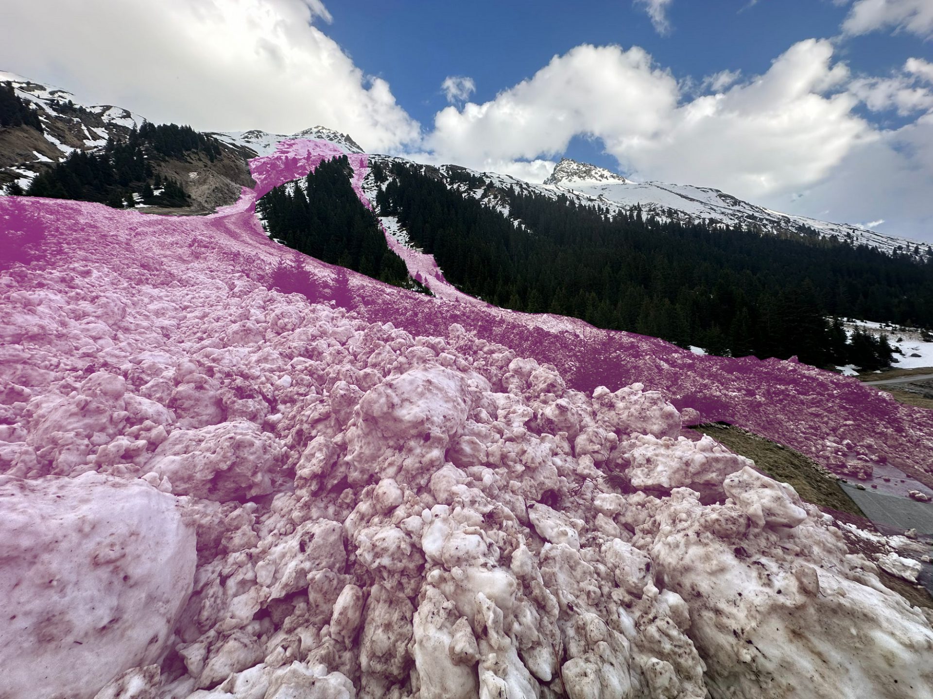
Avalanches from gliding snow
Avalanche headquarters in Tirol was informed of four avalanches involving persons in the 2023/24 season for which the cause was gliding snow. This is a very high number, since glide-snow avalanches are not triggered by persons, as are most avalanches in which there are casualties, but rather trigger themselves naturally. Thus, the complex conjunction of a naturally triggered avalanche in a certain spot at a certain moment together with the presence of persons in that spot at that moment is the prerequisite.
On Christmas Eve, 24 December, following the intensive precipitation on 21-23 December, a person walking along a forest road near Obergurgl in Ötztal was buried by the snow plume of a glide-snow avalanche which triggered further up. The person remained without injuries and was able to continue her stroll.
On 26 January a group of four ice climbers at the starting point to the Marchlehnfall in Pitztal was struck by a glide-snow avalanche. One person suffered serious injuries. It had snowed just before this incident and the snowfall level was initially above the treeline; but as temperatures dropped the snowfall level descended to intermediate altitudes. Thus, it was a combination of the additional burden on the snowpack plus rainfall at the borderline between the ground greenery and the snow.
For the third glide-snow avalanche involving persons, moist/warm air masses which moved in during the nocturnal hours of 17 February in the wake of a cold snap were responsible, bringing rainfall to above 2500m in Tirol. Due to the marked rise in temperature, numerous wet-snow and glide-snow avalanches were recorded that weekend, including one near the Pfundsalm in Hochfügen. Two persons were caught in the plummeting snow masses. Both were deposited on top of them and remained without injuries.
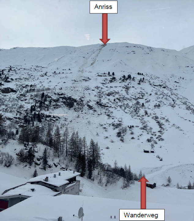
On 9 April, an incident due to a naturally triggered glide-snow avalanche on the Bärenkopf in the eastern Karwendel proved fatal. For details of this incident, see the following section of avalanche accidents in Tirol.
During a further avalanche incident near the Franz Senn Refuge on 23 April there were fortunately no persons involved. Nevertheless, an avalanche disgorged over a climbing route of the refuge on which the day before two persons had been en route. The gliding snow activity was observed with great anxiety by the refuge manager, since he knew the danger zones quite well from years of experience. What can be learned from this example? Based on the fact that glide-snow avalanches always trigger naturally and the point in time they unleash is utterly unpredictable, the risk can be minimized only to a certain degree by avoiding all zones below glide cracks or at very least, passing through them as swiftly as possible. Dealing with avalanche danger is, as can be seen, similar to risk management of glacier crevices and rockfall. It goes without saying, such recommendations can only be heeded when the potential fracture points of glide-snow avalanches are known so that one can avoid placing oneself in harm’s way unknowingly.
Three comparable situations
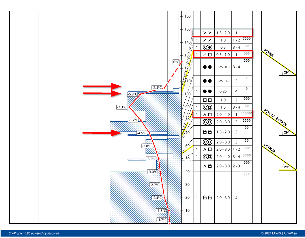
At the beginning of December, mid-to-end February, and in early March, there was heavy precipitation, each with similar points of departure: we found striking and persistent weak layers near the snowpack surface. These were mostly attached to melt-freeze crusts which had formed up to high altitudes during the previous periods of precipitation. In early March, what’s more, there was also surface hoar that night prior to the rainfall. A worrisome point of departure, therefore, in view of the heavy snowfall.
The precipitation events themselves which led to the weak layers getting blanketed by fresh snowfall were also comparable: they were quite intensive, and accompanied by dropping temperatures and diminishing wind velocities. From our vantage point, these cases were equally troublesome, they had all the ingredients for intense avalanche activity: lots of fresh snow blanketing the near-surface weak layers which also generated the requisite slab where it was able to bond as a result of wind and/or radiation factors. In addition, avalanche prone locations were covered by fresh fallen snow because of the diminished wind, making them difficult to recognize. All three situation were thus labeled with “high avalanche danger” in those parts of Tirol. We expected many avalanche prone locations where even large-sized avalanches could easily be triggered.
In retrospect these three scenarios had something else in common: during the snowfall where high avalanche danger was assigned (both for large-sized naturally triggered releases and for successful artificial triggerings), the snowpack’s proneness to triggering swiftly and unexpectedly diminished. There were different causes for this: at the beginning of December and in mid-to-end of February, observations from outlying terrain permitted the conclusion that the slab was not particularly threatening. The fresh snow was loosely-packed due to the lack of wind and low temperatures, making no fracture propagation possible. In exposed spots where the wind was able to form a slab, the snowpack was extremely prone to triggering, but elsewhere there was frequently good powder snow. Thus, all in all, there were far fewer danger zones than originally assumed. At the start of March, following high avalanche activity during the snowfall, we assumed that high trigger-sensitivity of the snowpack would persist even after the precipitation, brought about by improvement in weather conditions (and the solar radiation and higher temperatures which would consolidate the snow). In fact, the peak of avalanche activity was actually reached previously, since the slab was able to form during the precipitation through a rise in temperature and therefore, large numbers of avalanches triggered in places where there was surface hoar at that earlier juncture, after which the situation quickly improved.
When the three events were viewed later on, it was clear that the avalanche situation had been viewed overly critically, particularly on the day after the snowfall. In the analysis of our evaluations, we reconstructed the point of departure, the development of the situation and the conclusions we drew based on these factors. Our ultimate conclusion was: based on the data which we had at our disposal at the time, we would evaluate the situation in the same way today. The swift improvement of the situation was not foreseeable due to wind influence in the Alps, which is always very difficult to forecast, making its effect on the development of an avalanche situation complex and highly unsure. This is particularly the case with regard to the local variability of wind velocities. For our readers, the lesson remains that even an Avalanche Bulletin is only a forecast, the actual situation on-site in outlying terrain must be compared with the report’s predictions, possibly adapted to conditions which are at variance with it when planning a backcountry tour.
“The Avalanche Bulletin is but a forecast. It works with huge uncertain factors. Therefore, the situation on-site must always be compared with the forecast and personal expectations.” Matthias Walcher