Wir erwarten vermehrte Lawinenaktivität

Snowfall after long period of cold – regionally a delicate, increasingly accident-prone avalanche situation

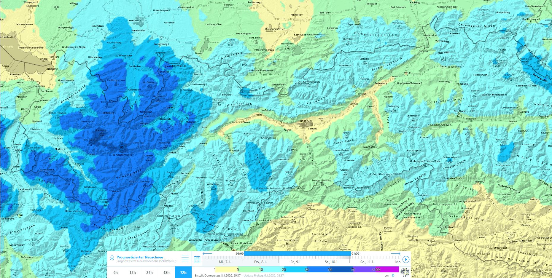
Following an extended period with very little precipitation and, in the end, very cold weather, a frontal system is bringing heavy snowfall to the western regions, expected to last through Sunday, 11.01.2026. The snow will fall on an unfavorably structured snowpack. Consequence: at least in the major areas of precipitation we will be subjected to an “avalanche period” starting Sunday at latest, a situation which is particularly accident-prone for winter sports enthusiasts.

Restraint is the key to accident prevention

Not a pleasant situation: after a long period of ‘thirst’ with severely below-average snow depths, finally the much desired snowfall is coming, at least to western regions. And as luck would have it, we now have to put on the brakes and practice restraint!

The explanation is simple:
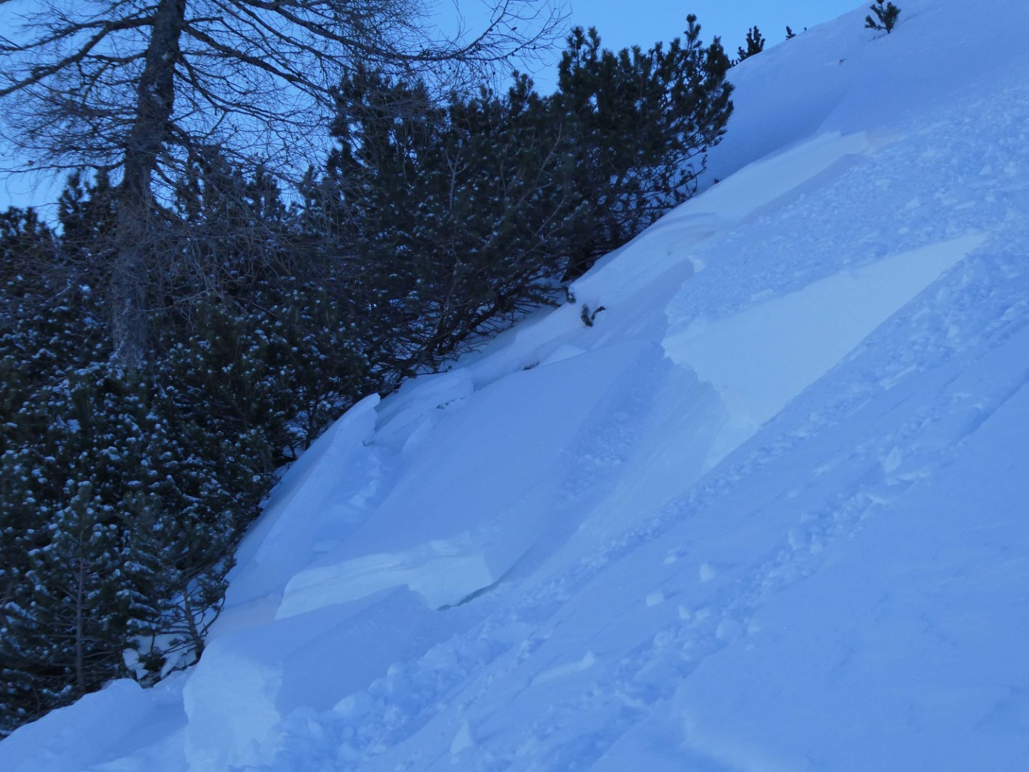
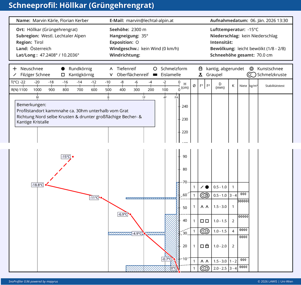
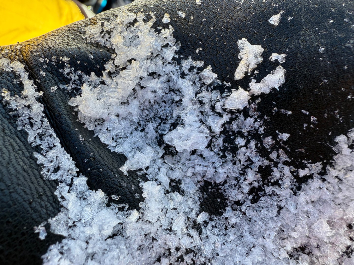
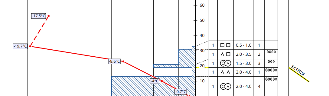
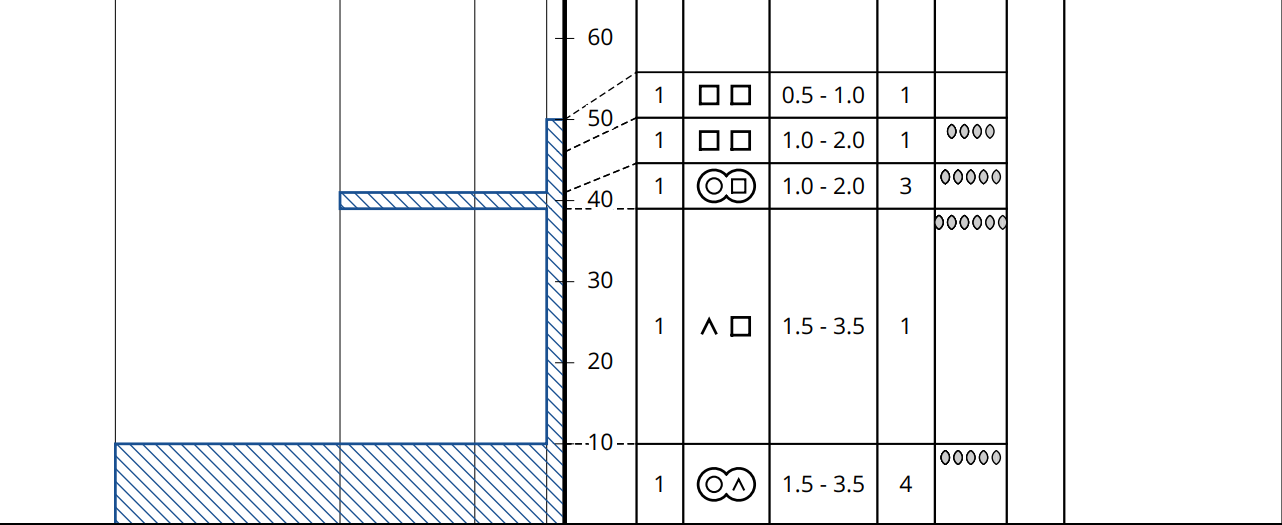
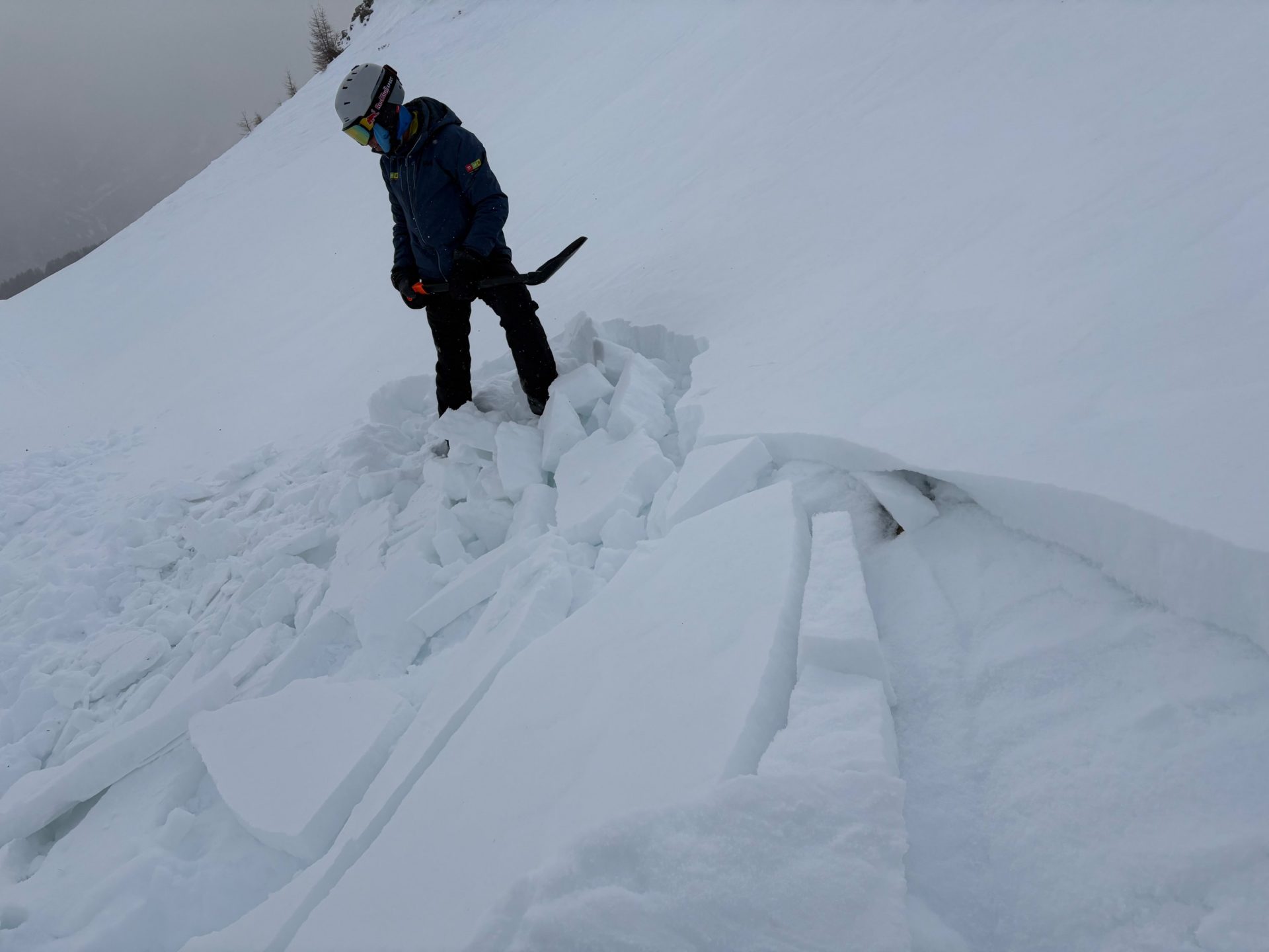
The shallow snowpack is extremely poorly structured over widespread areas. Near the snowpack surface are significant weak layers of faceted crystals and even rotten snow. What’s more, in many cases these weak layers are located between thin (old) melt-freeze crusts or wind crusts, forming a “crust sandwich.” There is also surface hoar on top, or else fresh snow from 2-3 January which until yesterday was exposed to intense cold and has expansively metamorphosed – all this constitutes potential weak layers.
And now, on top of these weak layers, a marked slab will be generated as a result of snowfall accompanied by strong-to-storm strength wind impact. And to top it off, we are confronted with a highly trigger-sensitive snowpack, as we see from recent reports from outlying terrain: first observations of fractures and settling noises (of the still very shallow snowpack). Our American colleagues call the snowpack in such situations “touchy” – in other words, even delicate contact is enough to disturb the snowpack.
As if that weren’t enough, in the major regions of precipitation starting on Sunday, 11.01.2026, wherever there was an area-wide cohesive snowpack prior to the snowfall, we can expect very good, even large-scale propagation of fractures.

Very weak snowpack

Schneeprofile, wie hier in der Arlberg-Region in einem Osthang auf 2300m, zeigen ein sehr ähnliches Bild: Es überwiegen kantige Schichten bzw. Schwimmschnee, welche häufig von dünnen Krusten umgeben sind. Die Schmelzkruste in Bodennähe stammt vom 02.11.2025, jene bei 30cm von den Regenereignissen am 07.12./08.12. und am 16.12./17.12.2025
Snow profiles such as this one from the Arlberg region on an east-facing slope at 2300m, show a very similar picture: faceted layers predominate and/or rotten snow which is often surrounded by thin crusts. The melt-freeze crust near ground level stems from 02.11.2025, the one at 30cm from the rainfall on 7 and 16-17 December.
Becherkristalle vom oben dargestellten Profil. (© Marvin Kärle, 07.01.2026)
Cup-shaped crystals from the snow profile above (© Marvin Kärle, 06.01.2026)
Schneeprofil am Zwölferkogel in der Region Kühtai-Geigenkamm auf 2115m in einem 30 Grad steilen Nordhang vom 07.01.2026: Mögliche Schwachschichten gibt es hier an der Schneeoberfläche und unterhalb der dünnen Schmelzkruste bei 21-19cm, welche vom Regen am 07.12./08.12. und 16./17.12.2025 stammt. (© Lukas Ruetz)
Snow profile on Zwölferkogel in the Kühtai-Geigenkamm region at 2115m on a 30° gradient north-facing slope from 07.01.2026: potential weak layers are evident on the snowpack surface and beneath the thin melt-freeze crust at 21-19cm which were generated during the rainfall on 7-8 December and 16-17 December. (© Lukas Ruetz)
Ein sehr ähnliches Bild bei dem Schneeprofil vom 08.01.2026 in der Weißkugelgruppe auf 2560m in einem 30 Grad steilen Nordhang: Ausgeprägte Schwachschichten aus kantigen Kristallen und Schwimmschnee (© Tobias Holzknecht)
A very similar picture in the snow profile from 8 January 2026 in the Weisskugel Massif at 2560m on a 30° gradient north-facing slope: marked weak layers of faceted crystals and rotten snow. (© Tobias Holzknecht)
Unter einer oberflächennahen Kruste rieselt Schwimmschnee heraus: Goldried / Nahbereich Großglockner-Resort am 08.01.2026 (© Anton Riepler)
Beneath a near-surface crust, rotten snow pours forth: Goldried / vicinity of Grossglockner resort (© Anton Riepler, 08.01.2026)
Lockerer, der Kälte ausgesetzter "Pulver" an der Schneeoberfläche als weit verbreitete, mögliche Schwachschicht, sobald diese von Triebschnee überlagert wird. Grieskogelgruppe (© Barbara Fink, 03.01.2026)
Loosely-packed powder which was exposed to low temperatures blankets the surface, thus forming a far-reaching potential weak layer as soon as it is covered over by snowdrifts. Grieskogel Massif (© Barbara Fink, 03.01.2026)

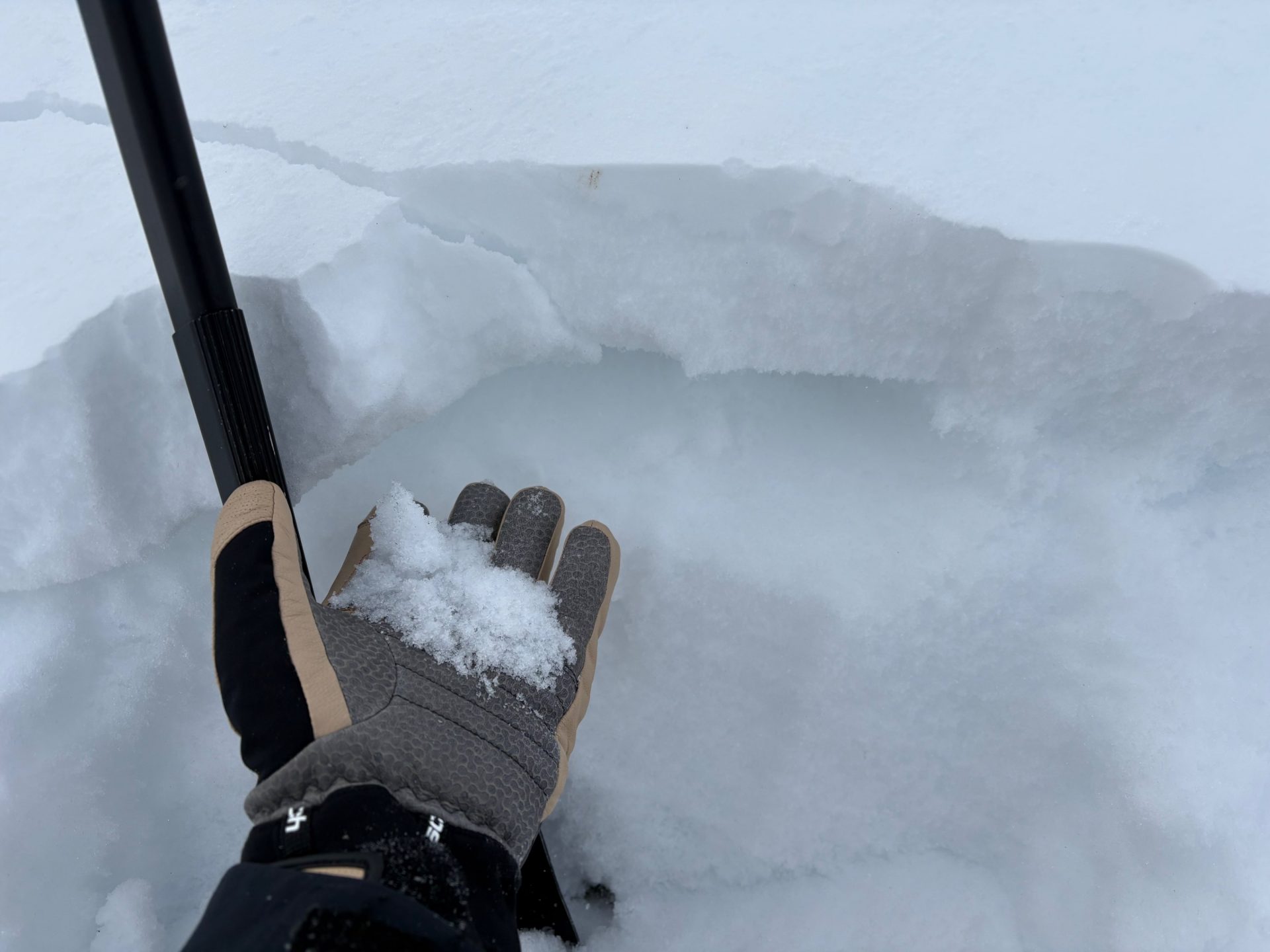
Whumpf noises and fractures are clear alarm signals, signifying a high proneness to triggering of the snow cover. Such alarm signals will be observed often over the next few days. In the major areas of precipitation in the western regions, we anticipate at latest starting Saturday, 10.01, to Sunday, 11.01, as a result of more snowfall, additional significant alarm signals, namely, naturally triggered avalanche releases.

Beim Betreten der Schneedecke ertönte ein Wummgeräusch- Ebenso bildeten sich Risse in der Triebschneelinse. Die Risse erkennt man u.a. links des Tourengehers bzw. etwas oberhalb der Skispur, welche von links nach rechts ansteigt. Sellrain. (© Fynn Renner, 04.01.2026)
When treading on the snowpack, a settling noise was heard. There were also fractures in the patch of snowdrift. The fracture is visible left of the tourer and somewhat above the ski track that ascends from left to right. Sellrain. The snowdrift mass probably was generated during the period of heavy wind impact on 2-3 January. (© Fynn Renner, 04.01.2026)
Rissbildungen in der Goldried-Gruppe (© Anton Riepler, 08.01.2026)
Fractures in the Goldried Massif (© Anton Riepler, 08.01.2026)

The slab

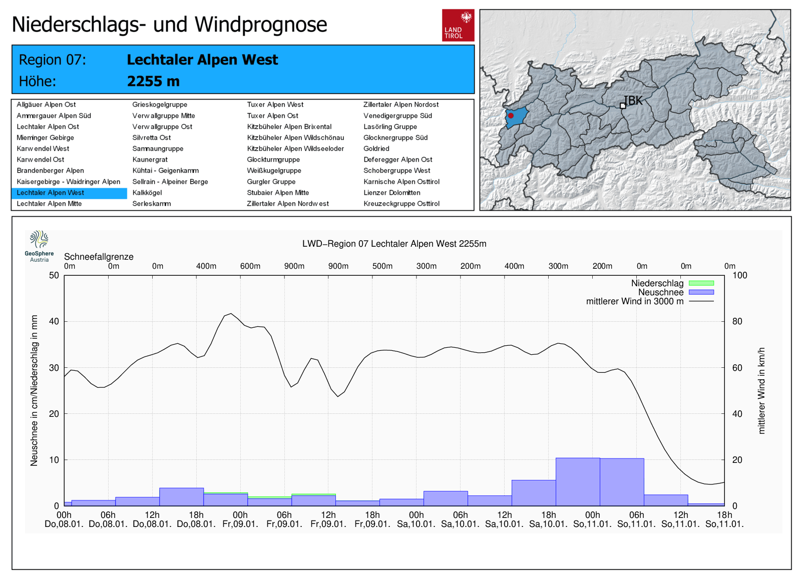
The “slab” which is the prerequisite for slab avalanches will be generated by current and coming snowfall accompanied by strong-to-stormy winds.

3-Tages-Neuschneeprognose. Im Westen des Landes ist mit etwa einem halben Meter Schnee zu rechnen.
In the western regions, we expect about a half-metre of fresh fallen snow.
Zeitlicher Verlauf des Neuschnees, der Wind- und Temperaturentwicklung für die Regeion der Lechtaler Alpen West, jener Region mit dem meisten prognostizierten Neuschnee.
Time-measured progress of fresh snowfall, wind and temperature developments hour-by-hour for the Lechtal Alps West region, which expects the highest amounts of fresh fallen snow. The most intensive snowfall is anticipated between Saturday and Sunday.
Der Wind legt zu und weht in Böen stark bis stürmisch aus westlichen Richtungen.
Westerly winds will intensify, be blowing at strong-to-storm strength, often in gusts.
Die vergangene Woche war durch große Kälte geprägt. Wenig Niederschlag samt starkem Wind gabs am vom 02.01. auf den 03.01. Nun fällt im Westen der prognostizierte Neuschnee der Warmfront. Auch der Wind hat wieder deutlich zugelegt. Wetterstation Predigberg in der Silvretta.
Last week was marked by intense cold. From 2-3 January there was a small amount of precipitation accompanied by strong winds. Now, the forecast snowfall in western regions from the warm front (the rising temperatures are visible). Also the winds have measurably intensified. Predigberg weather station in the Silvretta.

Weather developments and high point of avalanche danger

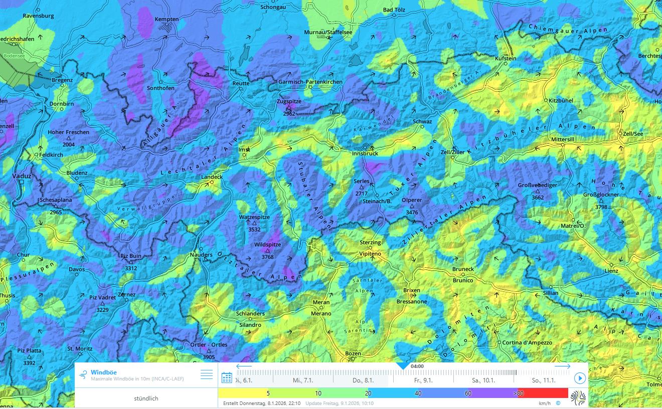
According to Geosphere Austria, a warm front currently dominates the weather developments in Tirol. This warm front will bring 10-20cm of fresh snow to the western regions, maximum 10cm to the eastern regions, while South Tirol will get next to nothing. Winds will be blowing at strong velocity from the west. On Friday the situation is expected to improve during the daytime hours, temperatures will drop again, it will remain very windy in the mountains. Starting on Saturday the high-altitude air current will shift to northwesterly and moist-cold air masses will again flow our way. The major bout of precipitation will be from Saturday, 10.01, until Sunday, 11.01, in western regions, accompanied by ongoing strong wind. On Sunday, the cloud cover will begin to disperse over the course of the day.

The peak of avalanche danger is expected to be during the nocturnal hours on Saturday-to-Sunday, when heavy and intense snowfall is anticipated. At latest, that is when increasingly frequent naturally-triggered avalanches can be expected with the highest probability. As of that point in time, we anticipate in western regions the “avalanche period” referred to above, during which for at least several days we expect a dangerous avalanche situation in outlying terrain for winter sports enthusiasts and, thus, it is a highly accident-prone time. It will also be the period when remote triggerings can be expected in the major areas of precipitation.

As a final note, we want to urge all of you to adopt extremely defensive conduct over the next few days! Winter sports enthusiats who venture into backcountry need to be keenly aware of the risks and have the requisite experience in assessing avalanche dangers along the way.